Santa Catarina, Cape Verde
| Santa Catarina | |
|---|---|
| Municipality | |
 | |
 | |
| Coordinates: 15°06′N 23°43′W / 15.10°N 23.71°WCoordinates: 15°06′N 23°43′W / 15.10°N 23.71°W | |
| Country | Cape Verde |
| Island | Santiago |
| Area | |
| • Total | 242.6 km2 (93.7 sq mi) |
| Population (2010)[1] | |
| • Total | 43,297 |
| • Density | 180/km2 (460/sq mi) |
| Website |
cmscst |
Santa Catarina is a concelho (municipality) of Cape Verde. It is situated in the western part of the island of Santiago. Its seat is the city of Assomada. Its population was 45,920 in 2017 (estimate).[2]
Subdivisions
The municipality consists of one freguesia (civil parish), Santa Catarina. The freguesia is subdivided into the following settlements (population data as of 2010):[1]
- Achada Galego (pop: 865)
- Achada Gomes (pop: 743)
- Achada Lazão (pop: 2)
- Achada Leite (pop: 142)
- Achada Lem (pop: 2,088)
- Achada Ponta (pop: 195)
- Achada Tossa (pop: 742)
- Aguas Podres (pop: 205)
- Arribada (pop: 286)
- Assomada (pop: 12,332, city)[3]
- Banana Semedo (pop: 428)
- Boa Entrada (pop: 1,119)
- Boa Entradinha (pop: 637)
- Bombardeiro (pop: 914)
- Chã de Lagoa (pop: 381)
- Chã de Tanque (pop: 1,164, town)[3]
- Charco (pop: 266)
- Cruz Grande (pop: 798)
- Entre Picos (pop: 411)
- Entre Picos de Reda (pop: 412)
- Figueira das Naus (pop: 1,157)
- Fonte Lima (pop: 894)
- Fonteana (pop: 747)
- Fundura (pop: 1,070)
- Furna (pop: 433)
- Gamchemba (pop: 107)
- Gil Bispo (pop: 998)
- Japluma (pop: 156)
- João Bernardo (pop: 317)
- João Dias (pop: 546)
- Junco (pop: 336)
- Librão (pop: 391)
- Lugar Velho (pop: 10)
- Mancholy (pop: 903)
- Mato Baixo (pop: 488)
- Mato Gege (pop: 704)
- Mato Sancho (pop: 414)
- Palha Carga (pop: 978)
- Pata Brava (pop: 197)
- Pau Verde (pop: 256)
- Pingo Chuva (pop: 505)
- Pinha dos Engenhos (pop: 650)
- Ribeira da Barca (pop: 2,317)
- Ribeira Riba (pop: 192)
- Ribeirão Isabel (pop: 409)
- Ribeirão Manuel (pop: 1,086)
- Rincão (pop: 1,048)
- Saltos Acima (pop: 105)
- Sedeguma (pop: 122)
- Serra Malagueta (pop: 572)
- Tomba Touro (pop: 82)
Geography
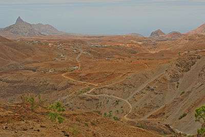
The municipality of Santa Catarina has a rugged relief, characterised by steep slopes that border the river valleys, rocky peaks and volcanic cones. Its mountains, including Serra Malagueta and Pico da Antónia, are the highest of the island.[4]:19 Santa Catarina borders Tarrafal to the north, São Miguel to the northeast, Santa Cruz to the east, São Salvador do Mundo to the southeast and Ribeira Grande de Santiago to the south.
History
.jpg)
The municipality of Santa Catarina was created in 1834. At this time, it consisted of the parishes Santa Catarina do Mato (the current municipality of Santa Catarina), São Salvador do Mundo, São Miguel, Santo Amaro Abade and São João Baptista.[4]:19 Initially, its seat was the new town of Picos, between 1859 and 1869 it was Achada Falcão (Cruz Grande), between 1869 and 1912 Tarrafal, and since 1912 Assomada.[4]:37-43
The parish São João Baptista became part of the municipality of Praia in 1872.[4]:29 In 1917, the two northern parishes of the municipality Santo Amaro Abade and São Miguel were split off to become the Municipality of Tarrafal.[5] In May 2005, the eastern parish of São Salvador do Mundo was split off to become a separate municipality.[6]
Demography
| Population of Santa Catarina, Cape Verde (1940—2017) | ||||||||
|---|---|---|---|---|---|---|---|---|
| 1940[7][8] | 1950[7][8] | 1960[7][8] | 1970[7][8] | 1980[7][8] | 1990[7][8] | 2000[8][9] | 2010[2][1] | 2017[2] |
| 26848 | 19428 | 30207 | 41462 | 41012 | 41584 | 50024 | 43297 | 45920 |
Persons
- Víctor Borges, once the foreign minister of Cape Verde
- Arlindo Gomes Furtado, current bishop of Santiago de Cabo Verde which covers all of the Sotavento Islands
- Danielson Gomes Monteiro, footballer
- Gilyto, singer
- Suzanna Lubrano, singer
- António Mascarenhas Monteiro (February 16, 1944-September 2016), a former president of Cape Verde from March 22, 1991 to March 22, 2001.
- Wania Monteiro, athlete
- Ivone Ramos (b.July 9, 1926)
- José Maria Neves (b. March 28, 1960), Cape Verdean statesman
- Gil Semedo, singer
- Tcheka, singer
- Manuel Veiga (b. March 27, 1948), Cape Verdean writer
Politics
At the federal level, it belongs to the constituency of Santiago North. Since 2012, the Movement for Democracy (MpD) is the ruling party of the municipality. The results of the latest elections, in 2016:[10]
| Party | Municipal Council | Municipal Assembly | ||
|---|---|---|---|---|
| Votes% | Seats | Votes% | Seats | |
| MpD | 49.86 | 9 | 49.74 | 11 |
| PAICV | 47.17 | 0 | 47.17 | 10 |
Presidents
- José Maria Neves (2000-2001), later became Prime Minister
- Francisco Tavares (2012-2016)
- José Alves Fernandes (2016-)
Festivities
The municipality's main festivity is the festival of Saint Catherine which takes place on November 24.
International relations
Santa Catarina is twinned with:

References
- 1 2 3 "2010 Census results". Instituto Nacional de Estatística Cabo Verde (in Portuguese). 24 November 2016.
- 1 2 3 "Cape Verde Population Statistics". citypopulation.de.
- 1 2 Cabo Verde, Statistical Yearbook 2015, Instituto Nacional de Estatística, p. 32-33
- 1 2 3 4 Evolução histórica do Concelho de Santa Catarina (1834 – 1912), Ana Zenaida Gomes, 2005
- ↑ "History" (in Portuguese). Municipality of Tarrafal.
- ↑ Lei nº 65/VI/2005, p. 43
- 1 2 3 4 5 6 Source: Statoids
- 1 2 3 4 5 6 7 Includes the population of the present-day São Salvador do Mundo municipality.
- ↑ Source: Instituto Nacional de Estatísticas Archived 2008-11-18 at the Wayback Machine..
- ↑ Official results local elections 2016, Boletim Oficial I Série, Número 53, 23 September 2016
- 1 2 3 "Geminações de Cidades e Vilas" [Twinning of Cities and Towns]. Associação Nacional de Municípios Portugueses [National Association of Portuguese Municipalities] (in Portuguese). Retrieved 2018-08-20.
External links
- In Portuguese:
The island of Santiago | ||
|---|---|---|
| Mountains | 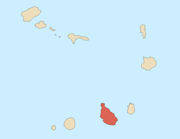 | |
| Streams | ||
| Points and promontories | ||
| Other geographic features | ||
| Transportation | ||
| Other topics | ||
| ||