Farol da Ponta Norte
 Cape Verde | |
| Location |
Ponta Norte Cape Verde |
|---|---|
| Coordinates | 16°51′5.2″N 22°54′54.3″W / 16.851444°N 22.915083°WCoordinates: 16°51′5.2″N 22°54′54.3″W / 16.851444°N 22.915083°W |
| Year first constructed |
1897 (first) ~1940 (second, now in ruins) |
| Deactivated |
~1940 (first) ~1960 (second) |
| Foundation | concrete base |
| Construction |
metal skeletal tower (current) masonry tower (second) |
| Tower shape |
square prism skeletal tower (current) cylindrical tower (second) |
| Markings / pattern | white tower (second) |
| Height |
4.8 metres (16 ft) (current) 10.9 metres (36 ft) (second) [1] |
| Focal height | 16 metres (52 ft) (current) [1] |
| Light source | solar power |
| Range | 8 nautical miles (15 km; 9.2 mi)[1] |
| Characteristic | Fl (3) W 12s.[1] |
| Admiralty number | D2919.75 |
| NGA number | 24147 |
| Cape Verde number | PT-2070[2] |
Farol de Ponta Norte is a lighthouse in the northernmost point of the island of Sal, Cape Verde. It is located near the headland Ponta Norte. The original lighthouse was a 13 metres high cast iron tower, constructed in 1897. This was replaced with a masonry tower around 1940, which is now in ruins. The current light is on a 5 metres metal tower.[2]
See also
References
- 1 2 3 4 List of Lights, Pub. 113: The West Coasts of Europe and Africa, the Mediterranean Sea, Black Sea and Azovskoye More (Sea of Azov) (PDF). List of Lights. United States National Geospatial-Intelligence Agency. 2018. p. 426.
- 1 2 Rowlett, Russ. "Lighthouses of Cape Verde". The Lighthouse Directory. University of North Carolina at Chapel Hill. Retrieved 15 August 2018.
External links
The island of Sal, Cape Verde | ||
|---|---|---|
| Settlements | 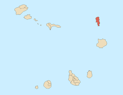 | |
| Mountains and hills | ||
| Points and promontories | ||
| Lighthouses | ||
| Other geographical features | ||
| Other topics | ||
This article is issued from
Wikipedia.
The text is licensed under Creative Commons - Attribution - Sharealike.
Additional terms may apply for the media files.