Sainte-Colombe-en-Auxois
| Sainte-Colombe-en-Auxois | |
|---|---|
| Commune | |
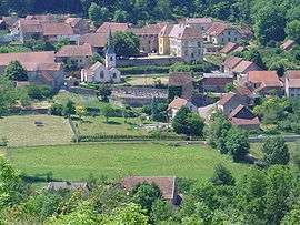 A general view of Sainte-Colombe-en-Auxois | |
 Sainte-Colombe-en-Auxois Location within Bourgogne-Franche-Comté region  Sainte-Colombe-en-Auxois | |
| Coordinates: 47°25′40″N 4°27′31″E / 47.4278°N 4.4586°ECoordinates: 47°25′40″N 4°27′31″E / 47.4278°N 4.4586°E | |
| Country | France |
| Region | Bourgogne-Franche-Comté |
| Department | Côte-d'Or |
| Arrondissement | Montbard |
| Canton | Semur-en-Auxois |
| Government | |
| • Mayor (2008–2014) | Thérèse Flacelière |
| Area1 | 6.29 km2 (2.43 sq mi) |
| Population (2008)2 | 69 |
| • Density | 11/km2 (28/sq mi) |
| Time zone | UTC+1 (CET) |
| • Summer (DST) | UTC+2 (CEST) |
| INSEE/Postal code | 21544 /21350 |
| Elevation |
333–498 m (1,093–1,634 ft) (avg. 405 m or 1,329 ft) |
|
1 French Land Register data, which excludes lakes, ponds, glaciers > 1 km2 (0.386 sq mi or 247 acres) and river estuaries. 2 Population without double counting: residents of multiple communes (e.g., students and military personnel) only counted once. | |
Sainte-Colombe-en-Auxois (before 2014: Sainte-Colombe)[1] is a commune in the Côte-d'Or department in eastern France.
Population
| Historical population | ||
|---|---|---|
| Year | Pop. | ±% |
| 1962 | 48 | — |
| 1968 | 56 | +16.7% |
| 1975 | 44 | −21.4% |
| 1982 | 45 | +2.3% |
| 1990 | 53 | +17.8% |
| 1999 | 59 | +11.3% |
| 2008 | 69 | +16.9% |
See also
References
- ↑ Décret n° 2014-1447 3 December 2014 (in French)
| Wikimedia Commons has media related to Sainte-Colombe (Côte-d'Or). |
This article is issued from
Wikipedia.
The text is licensed under Creative Commons - Attribution - Sharealike.
Additional terms may apply for the media files.