Bretenière
| Bretenière | ||
|---|---|---|
| Commune | ||
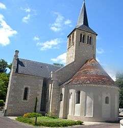 The church in Bretenière | ||
| ||
 Bretenière Location within Bourgogne-Franche-Comté region  Bretenière | ||
| Coordinates: 47°14′29″N 5°06′54″E / 47.2414°N 5.115°ECoordinates: 47°14′29″N 5°06′54″E / 47.2414°N 5.115°E | ||
| Country | France | |
| Region | Bourgogne-Franche-Comté | |
| Department | Côte-d'Or | |
| Arrondissement | Dijon | |
| Canton | Longvic | |
| Intercommunality | Dijon Métropole | |
| Government | ||
| • Mayor (2008–2014) | Alain Linger | |
| Area1 | 6.03 km2 (2.33 sq mi) | |
| Population (2008)2 | 737 | |
| • Density | 120/km2 (320/sq mi) | |
| Time zone | UTC+1 (CET) | |
| • Summer (DST) | UTC+2 (CEST) | |
| INSEE/Postal code | 21106 /21110 | |
| Elevation | 206–215 m (676–705 ft) | |
|
1 French Land Register data, which excludes lakes, ponds, glaciers > 1 km2 (0.386 sq mi or 247 acres) and river estuaries. 2 Population without double counting: residents of multiple communes (e.g., students and military personnel) only counted once. | ||
.svg.png)
Bretenière is a commune in the Côte-d'Or department in eastern France.
Population
| Historical population | ||
|---|---|---|
| Year | Pop. | ±% |
| 1793\155 | 1,800 | — |
| 149 | 1,806 | +0.3% |
| 156 | 1,821 | +0.8% |
| 181 | 1,831 | +0.5% |
| 180 | 1,836 | +0.3% |
| 205 | 1,841 | +0.3% |
| 189 | 1,846 | +0.3% |
| 194 | 1,851 | +0.3% |
| 190 | 1,856 | +0.3% |
| 183 | 1,861 | +0.3% |
| 182 | 1,866 | +0.3% |
| 171 | 1,872 | +0.3% |
| 166 | 1,876 | +0.2% |
| 158 | 1,881 | +0.3% |
| 153 | 1,886 | +0.3% |
| 170 | 1,891 | +0.3% |
| 205 | 1,896 | +0.3% |
| 177 | 1,901 | +0.3% |
| 158 | 1,906 | +0.3% |
| 178 | 1,911 | +0.3% |
| 180 | 1,921 | +0.5% |
| 164 | 1,926 | +0.3% |
| 180 | 1,931 | +0.3% |
| 185 | 1,936 | +0.3% |
| 254 | 1,946 | +0.5% |
| 236 | 1,954 | +0.4% |
| 283 | 1,962 | +0.4% |
| 338 | 1,968 | +0.3% |
| 436 | 1,975 | +0.4% |
| 446 | 1,982 | +0.4% |
| 513 | 1,990 | +0.4% |
| 675 | 1,999 | +0.5% |
| 776 | 2,008 | +0.5% |
| 737 | — | |
See also
References
External links
| Wikimedia Commons has media related to Bretenière. |
This article is issued from
Wikipedia.
The text is licensed under Creative Commons - Attribution - Sharealike.
Additional terms may apply for the media files.