Poncey-lès-Athée
| Poncey-lès-Athée | ||
|---|---|---|
| Commune | ||
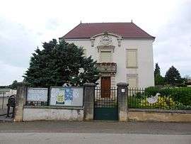 Town hall | ||
| ||
 Poncey-lès-Athée Location within Bourgogne-Franche-Comté region  Poncey-lès-Athée | ||
| Coordinates: 47°14′29″N 5°23′23″E / 47.2414°N 5.3897°E / 47.2414; 5.3897Coordinates: 47°14′29″N 5°23′23″E / 47.2414°N 5.3897°E / 47.2414; 5.3897 | ||
| Country | France | |
| Region | Bourgogne-Franche-Comté | |
| Department | Côte-d'Or | |
| Arrondissement | Dijon | |
| Canton | Auxonne | |
| Government | ||
| • Mayor (2008–2014) | Jean-Pierre Morin | |
| Area1 | 6.53 km2 (2.52 sq mi) | |
| Population (2008)2 | 544 | |
| • Density | 83/km2 (220/sq mi) | |
| Time zone | UTC+1 (CET) | |
| • Summer (DST) | UTC+2 (CEST) | |
| INSEE/Postal code | 21493 /21130 | |
| Elevation |
182–208 m (597–682 ft) (avg. 205 m or 673 ft) | |
|
1 French Land Register data, which excludes lakes, ponds, glaciers > 1 km2 (0.386 sq mi or 247 acres) and river estuaries. 2 Population without double counting: residents of multiple communes (e.g., students and military personnel) only counted once. | ||
.svg.png)
Poncey-lès-Athée is a commune in the Côte-d'Or department in eastern France.
Population
| Historical population | ||
|---|---|---|
| Year | Pop. | ±% |
| 1962 | 358 | — |
| 1968 | 370 | +3.4% |
| 1975 | 357 | −3.5% |
| 1982 | 365 | +2.2% |
| 1990 | 380 | +4.1% |
| 1999 | 396 | +4.2% |
| 2008 | 544 | +37.4% |
See also
References
| Wikimedia Commons has media related to Poncey-lès-Athée. |
This article is issued from
Wikipedia.
The text is licensed under Creative Commons - Attribution - Sharealike.
Additional terms may apply for the media files.