Rouvres-en-Plaine
| Rouvres-en-Plaine | ||
|---|---|---|
| Commune | ||
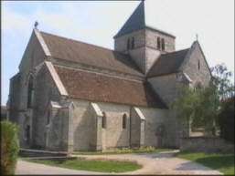 Collegial church of Saint Jean-Baptiste | ||
| ||
 Rouvres-en-Plaine Location within Bourgogne-Franche-Comté region  Rouvres-en-Plaine | ||
| Coordinates: 47°14′22″N 5°08′30″E / 47.2394°N 5.1417°ECoordinates: 47°14′22″N 5°08′30″E / 47.2394°N 5.1417°E | ||
| Country | France | |
| Region | Bourgogne-Franche-Comté | |
| Department | Côte-d'Or | |
| Arrondissement | Dijon | |
| Canton | Genlis | |
| Intercommunality | Plaine Dijonaise | |
| Government | ||
| • Mayor (2008–2014) | Hubert Sauvain | |
| Area1 | 14.64 km2 (5.65 sq mi) | |
| Population (2008)2 | 999 | |
| • Density | 68/km2 (180/sq mi) | |
| Time zone | UTC+1 (CET) | |
| • Summer (DST) | UTC+2 (CEST) | |
| INSEE/Postal code | 21532 /21110 | |
| Elevation | 200–216 m (656–709 ft) | |
|
1 French Land Register data, which excludes lakes, ponds, glaciers > 1 km2 (0.386 sq mi or 247 acres) and river estuaries. 2 Population without double counting: residents of multiple communes (e.g., students and military personnel) only counted once. | ||
.svg.png)
Rouvres-en-Plaine is a commune in the Côte-d'Or department in eastern France.
Population
| Historical population | ||
|---|---|---|
| Year | Pop. | ±% |
| 1793 | 420 | — |
| 1800 | 413 | −1.7% |
| 1806 | 636 | +54.0% |
| 1821 | 575 | −9.6% |
| 1836 | 546 | −5.0% |
| 1841 | 566 | +3.7% |
| 1846 | 600 | +6.0% |
| 1851 | 579 | −3.5% |
| 1856 | 503 | −13.1% |
| 1861 | 578 | +14.9% |
| 1866 | 534 | −7.6% |
| 1872 | 515 | −3.6% |
| 1876 | 497 | −3.5% |
| 1881 | 479 | −3.6% |
| 1886 | 467 | −2.5% |
| 1891 | 471 | +0.9% |
| 1896 | 465 | −1.3% |
| 1901 | 474 | +1.9% |
| 1906 | 460 | −3.0% |
| 1911 | 485 | +5.4% |
| 1921 | 427 | −12.0% |
| 1926 | 436 | +2.1% |
| 1931 | 463 | +6.2% |
| 1936 | 437 | −5.6% |
| 1946 | 452 | +3.4% |
| 1954 | 452 | +0.0% |
| 1962 | 412 | −8.8% |
| 1968 | 413 | +0.2% |
| 1975 | 580 | +40.4% |
| 1982 | 704 | +21.4% |
| 1990 | 797 | +13.2% |
| 1999 | 866 | +8.7% |
| 2008 | 999 | +15.4% |
See also
References
| Wikimedia Commons has media related to Rouvres-en-Plaine. |
This article is issued from
Wikipedia.
The text is licensed under Creative Commons - Attribution - Sharealike.
Additional terms may apply for the media files.