Mâlain
| Mâlain | ||
|---|---|---|
| Commune | ||
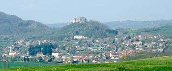 A general view of Mâlain | ||
| ||
 Mâlain Location within Bourgogne-Franche-Comté region  Mâlain | ||
| Coordinates: 47°19′36″N 4°47′44″E / 47.3267°N 4.7956°E / 47.3267; 4.7956Coordinates: 47°19′36″N 4°47′44″E / 47.3267°N 4.7956°E / 47.3267; 4.7956 | ||
| Country | France | |
| Region | Bourgogne-Franche-Comté | |
| Department | Côte-d'Or | |
| Arrondissement | Dijon | |
| Canton | Talant | |
| Government | ||
| • Mayor (2008–2014) | Nicolas Roze | |
| Area1 | 11.24 km2 (4.34 sq mi) | |
| Population (2008)2 | 703 | |
| • Density | 63/km2 (160/sq mi) | |
| Time zone | UTC+1 (CET) | |
| • Summer (DST) | UTC+2 (CEST) | |
| INSEE/Postal code | 21373 /21410 | |
| Elevation | 280–535 m (919–1,755 ft) | |
|
1 French Land Register data, which excludes lakes, ponds, glaciers > 1 km2 (0.386 sq mi or 247 acres) and river estuaries. 2 Population without double counting: residents of multiple communes (e.g., students and military personnel) only counted once. | ||
.svg.png)
Mâlain is a commune in the Côte-d'Or department in eastern France.
Population
| Historical population | ||
|---|---|---|
| Year | Pop. | ±% |
| 1962 | 493 | — |
| 1968 | 564 | +14.4% |
| 1975 | 510 | −9.6% |
| 1982 | 554 | +8.6% |
| 1990 | 660 | +19.1% |
| 1999 | 750 | +13.6% |
| 2008 | 703 | −6.3% |
Sights
- The Château Fort Saint-Georges, or Château Fort de Mâlain, is a ruined castle with origins from the 11th century.[1]
See also
References
- ↑ French Ministry of Culture: Château Fort Saint-Georges
| Wikimedia Commons has media related to Mâlain. |
This article is issued from
Wikipedia.
The text is licensed under Creative Commons - Attribution - Sharealike.
Additional terms may apply for the media files.