La Roche-en-Brenil
| La Roche-en-Brenil | ||
|---|---|---|
| Commune | ||
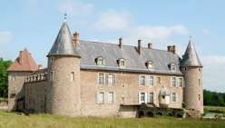 The chateau in La Roche-en-Brenil | ||
| ||
 La Roche-en-Brenil Location within Bourgogne-Franche-Comté region  La Roche-en-Brenil | ||
| Coordinates: 47°23′18″N 4°10′44″E / 47.3884°N 4.1789°E / 47.3884; 4.1789Coordinates: 47°23′18″N 4°10′44″E / 47.3884°N 4.1789°E / 47.3884; 4.1789 | ||
| Country | France | |
| Region | Bourgogne-Franche-Comté | |
| Department | Côte-d'Or | |
| Arrondissement | Montbard | |
| Canton | Semur-en-Auxois | |
| Intercommunality | Saulieu | |
| Government | ||
| • Mayor (2008–2014) | Gilles de Montalembert | |
| Area1 | 50.85 km2 (19.63 sq mi) | |
| Population (2008)2 | 919 | |
| • Density | 18/km2 (47/sq mi) | |
| Time zone | UTC+1 (CET) | |
| • Summer (DST) | UTC+2 (CEST) | |
| INSEE/Postal code | 21525 /21530 | |
| Elevation | 273–573 m (896–1,880 ft) | |
|
1 French Land Register data, which excludes lakes, ponds, glaciers > 1 km2 (0.386 sq mi or 247 acres) and river estuaries. 2 Population without double counting: residents of multiple communes (e.g., students and military personnel) only counted once. | ||
.svg.png)
La Roche-en-Brenil is a commune in the Côte-d'Or department in eastern France.
Population
| Historical population | ||
|---|---|---|
| Year | Pop. | ±% |
| 1962 | 1,009 | — |
| 1968 | 1,143 | +13.3% |
| 1975 | 1,082 | −5.3% |
| 1982 | 1,066 | −1.5% |
| 1990 | 890 | −16.5% |
| 1999 | 891 | +0.1% |
| 2008 | 919 | +3.1% |
See also
References
| Wikimedia Commons has media related to La Roche-en-Brenil. |
This article is issued from
Wikipedia.
The text is licensed under Creative Commons - Attribution - Sharealike.
Additional terms may apply for the media files.