Maisey-le-Duc
| Maisey-le-Duc | ||
|---|---|---|
| Commune | ||
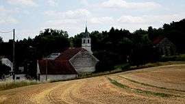 A general view of Maisey-le-Duc | ||
| ||
 Maisey-le-Duc Location within Bourgogne-Franche-Comté region  Maisey-le-Duc | ||
| Coordinates: 47°50′48″N 4°40′45″E / 47.8467°N 4.6792°E / 47.8467; 4.6792Coordinates: 47°50′48″N 4°40′45″E / 47.8467°N 4.6792°E / 47.8467; 4.6792 | ||
| Country | France | |
| Region | Bourgogne-Franche-Comté | |
| Department | Côte-d'Or | |
| Arrondissement | Montbard | |
| Canton | Châtillon-sur-Seine | |
| Intercommunality | Pays Châtillonnais | |
| Government | ||
| • Mayor (2008–2014) | Paul Brossault | |
| Area1 | 12.67 km2 (4.89 sq mi) | |
| Population (2008)2 | 107 | |
| • Density | 8.4/km2 (22/sq mi) | |
| Time zone | UTC+1 (CET) | |
| • Summer (DST) | UTC+2 (CEST) | |
| INSEE/Postal code | 21372 /21400 | |
| Elevation |
237–367 m (778–1,204 ft) (avg. 247 m or 810 ft) | |
|
1 French Land Register data, which excludes lakes, ponds, glaciers > 1 km2 (0.386 sq mi or 247 acres) and river estuaries. 2 Population without double counting: residents of multiple communes (e.g., students and military personnel) only counted once. | ||
.svg.png)
Maisey-le-Duc is a commune in the Côte-d'Or department in eastern France.
Population
| Historical population | ||
|---|---|---|
| Year | Pop. | ±% |
| 1962 | 127 | — |
| 1968 | 137 | +7.9% |
| 1975 | 105 | −23.4% |
| 1982 | 91 | −13.3% |
| 1990 | 91 | +0.0% |
| 1999 | 91 | +0.0% |
| 2008 | 107 | +17.6% |
See also
References
| Wikimedia Commons has media related to Maisey-le-Duc. |
This article is issued from
Wikipedia.
The text is licensed under Creative Commons - Attribution - Sharealike.
Additional terms may apply for the media files.