Frôlois
| Frôlois | |
|---|---|
| Commune | |
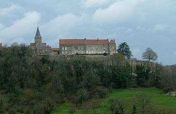 The chateau and church in Frôlois | |
 Frôlois Location within Bourgogne-Franche-Comté region  Frôlois | |
| Coordinates: 47°31′50″N 4°37′55″E / 47.5306°N 4.6319°E / 47.5306; 4.6319Coordinates: 47°31′50″N 4°37′55″E / 47.5306°N 4.6319°E / 47.5306; 4.6319 | |
| Country | France |
| Region | Bourgogne-Franche-Comté |
| Department | Côte-d'Or |
| Arrondissement | Montbard |
| Canton | Montbard |
| Government | |
| • Mayor (2008–2014) | Natharlie Guenebaut |
| Area1 | 34.77 km2 (13.42 sq mi) |
| Population (2008)2 | 176 |
| • Density | 5.1/km2 (13/sq mi) |
| Time zone | UTC+1 (CET) |
| • Summer (DST) | UTC+2 (CEST) |
| INSEE/Postal code | 21288 /21150 |
| Elevation |
299–482 m (981–1,581 ft) (avg. 400 m or 1,300 ft) |
|
1 French Land Register data, which excludes lakes, ponds, glaciers > 1 km2 (0.386 sq mi or 247 acres) and river estuaries. 2 Population without double counting: residents of multiple communes (e.g., students and military personnel) only counted once. | |
Frôlois is a commune in the Côte-d'Or department in eastern France.
Population
| Historical population | ||
|---|---|---|
| Year | Pop. | ±% |
| 1962 | 259 | — |
| 1968 | 303 | +17.0% |
| 1975 | 266 | −12.2% |
| 1982 | 248 | −6.8% |
| 1990 | 240 | −3.2% |
| 1999 | 190 | −20.8% |
| 2008 | 176 | −7.4% |
Sights
- Château de Frôlois: historic monument dating from 13th century.
See also
References
| Wikimedia Commons has media related to Frôlois. |
This article is issued from
Wikipedia.
The text is licensed under Creative Commons - Attribution - Sharealike.
Additional terms may apply for the media files.