Saint-Fortunat, Quebec
| Saint-Fortunat | |
|---|---|
| Municipality | |
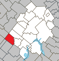 Location within Les Appalaches RCM. | |
 Saint-Fortunat Location in province of Quebec. | |
| Coordinates: 45°58′N 71°36′W / 45.967°N 71.600°WCoordinates: 45°58′N 71°36′W / 45.967°N 71.600°W[1] | |
| Country |
|
| Province |
|
| Region | Chaudière-Appalaches |
| RCM | Les Appalaches |
| Constituted | January 1, 1873 |
| Government[2] | |
| • Mayor | Denis Fortier |
| • Federal riding | Mégantic—L'Érable |
| • Prov. riding | Lotbinière-Frontenac |
| Area[2][3] | |
| • Total | 76.60 km2 (29.58 sq mi) |
| • Land | 75.92 km2 (29.31 sq mi) |
| Population (2011)[3] | |
| • Total | 280 |
| • Density | 3.7/km2 (10/sq mi) |
| • Pop 2006-2011 |
|
| • Dwellings | 164 |
| Time zone | UTC−5 (EST) |
| • Summer (DST) | UTC−4 (EDT) |
| Postal code(s) | G0P 1G0 |
| Area code(s) | 819 |
| Highways |
|
| Website |
www.municipalite saint-fortunat.net |
Saint-Fortunat is a municipality located in the Municipalité régionale de comté des Appalaches in Quebec, Canada. It is part of the Chaudière-Appalaches region and the population is 296 as of 2009. It was named after Christian poet Venantius Fortunatus.
References
- Commission de toponymie du Québec
- Ministère des Affaires municipales, des Régions et de l'Occupation du territoire
Places adjacent to Saint-Fortunat, Quebec | |
|---|---|
| Cities & Towns | |
|---|---|
| Municipalities | |
| Parishes | |
| |
This article is issued from
Wikipedia.
The text is licensed under Creative Commons - Attribution - Sharealike.
Additional terms may apply for the media files.