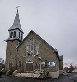
Sainte-Clotilde-de-Beauce, Quebec
| Sainte-Clotilde-de-Beauce | |
|---|---|
| Municipality | |
 | |
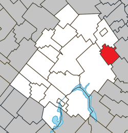 Location within Les Appalaches RCM | |
 Sainte-Clotilde-de-Beauce Location in province of Quebec | |
| Coordinates: 46°08′N 71°02′W / 46.13°N 71.03°WCoordinates: 46°08′N 71°02′W / 46.13°N 71.03°W[1] | |
| Country |
|
| Province |
|
| Region | Chaudière-Appalaches |
| RCM | Les Appalaches |
| Constituted | November 19, 1938 |
| Government[2] | |
| • Mayor | Gérald Grenier |
| • Federal riding | Mégantic—L'Érable |
| • Prov. riding | Beauce-Sud |
| Area[2][3] | |
| • Total | 60.80 km2 (23.48 sq mi) |
| • Land | 60.59 km2 (23.39 sq mi) |
| Population (2011)[3] | |
| • Total | 650 |
| • Density | 10.7/km2 (28/sq mi) |
| • Pop 2006-2011 |
|
| • Dwellings | 288 |
| Time zone | UTC−5 (EST) |
| • Summer (DST) | UTC−4 (EDT) |
| Postal code(s) | G0N 1C0 |
| Area code(s) | 418 and 581 |
| Highways |
|
| Website |
www |
Sainte-Clotilde-de-Beauce is a municipality located in the Municipalité régionale de comté des Appalaches in Quebec, Canada. It is part of the Chaudière-Appalaches region and the population is 606 as of 2009. It was named after Clotilde, Frankish queen and wife of Clovis I. "Beauce" refers to the municipality's former census division and helps to its differentiation with other Quebec municipalities named "Sainte-Clotilde."
References
External links

- Commission de toponymie du Québec
- Ministère des Affaires municipales, des Régions et de l'Occupation du territoire
Places adjacent to Sainte-Clotilde-de-Beauce, Quebec | ||||||||||
|---|---|---|---|---|---|---|---|---|---|---|
| ||||||||||
| Cities & Towns | |
|---|---|
| Municipalities | |
| Parishes | |
| |
This article is issued from
Wikipedia.
The text is licensed under Creative Commons - Attribution - Sharealike.
Additional terms may apply for the media files.