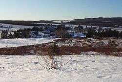
Saint-Jacques-le-Majeur-de-Wolfestown
| Saint-Jacques-le-Majeur -de-Wolfestown | |
|---|---|
| Parish municipality | |
 | |
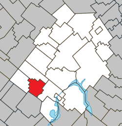 Location within Les Appalaches RCM | |
 Saint-Jacques-le-Majeur -de-Wolfestown Location in southern Quebec | |
| Coordinates: 45°56′N 71°30′W / 45.93°N 71.5°WCoordinates: 45°56′N 71°30′W / 45.93°N 71.5°W[1] | |
| Country |
|
| Province |
|
| Region | Chaudière-Appalaches |
| RCM | Les Appalaches |
| Constituted | September 30, 1909 |
| Government[2] | |
| • Mayor | Steven Laprise |
| • Federal riding | Mégantic—L'Érable |
| • Prov. riding | Lotbinière-Frontenac |
| Area[2][3] | |
| • Total | 61.60 km2 (23.78 sq mi) |
| • Land | 59.32 km2 (22.90 sq mi) |
| Population (2011)[3] | |
| • Total | 189 |
| • Density | 3.2/km2 (8/sq mi) |
| • Pop 2006-2011 |
|
| • Dwellings | 133 |
| Time zone | UTC−5 (EST) |
| • Summer (DST) | UTC−4 (EDT) |
| Postal code(s) | G0N 1E2 |
| Area code(s) | 418 and 581 |
| Highways |
|
| Website |
www |
Saint-Jacques-le-Majeur-de-Wolfestown is a parish municipality in Les Appalaches Regional County Municipality in the Chaudière-Appalaches region of Quebec, Canada. Its population is 189 as of the Canada 2011 Census.[3]
It was named after one of Jesus' first disciples, James, son of Zebedee. Wolfestown was the name of the historic township in which it is located, which was named after General James Wolfe.
References
External links

Places adjacent to Saint-Jacques-le-Majeur-de-Wolfestown | ||||||||||
|---|---|---|---|---|---|---|---|---|---|---|
| ||||||||||
| Cities & Towns | |
|---|---|
| Municipalities | |
| Parishes | |
| |
This article is issued from
Wikipedia.
The text is licensed under Creative Commons - Attribution - Sharealike.
Additional terms may apply for the media files.