Irlande
| Irlande | |
|---|---|
| Municipality | |
 | |
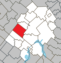 Location within Les Appalaches RCM. | |
 Irlande Location in province of Quebec. | |
| Coordinates: 46°04′N 71°29′W / 46.067°N 71.483°WCoordinates: 46°04′N 71°29′W / 46.067°N 71.483°W[1] | |
| Country |
|
| Province |
|
| Region | Chaudière-Appalaches |
| RCM | Les Appalaches |
| Constituted | July 1, 1855 |
| Government[2] | |
| • Mayor | Bruno Vézina |
| • Federal riding | Mégantic—L'Érable |
| • Prov. riding | Lotbinière-Frontenac |
| Area[2][3] | |
| • Total | 112.10 km2 (43.28 sq mi) |
| • Land | 109.42 km2 (42.25 sq mi) |
| Population (2011)[3] | |
| • Total | 959 |
| • Density | 8.8/km2 (23/sq mi) |
| • Pop 2006-2011 |
|
| • Dwellings | 408 |
| Time zone | UTC−5 (EST) |
| • Summer (DST) | UTC−4 (EDT) |
| Postal code(s) | G6H 2N7 |
| Area code(s) | 418 and 581 |
| Highways |
|
| Website |
www |
Irlande is a municipality in Les Appalaches Regional County Municipality in the Chaudière-Appalaches region of Quebec, Canada. Its population was 959 as of the Canada 2011 Census.
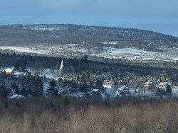
Irlande does not have a town or village centre, but the hamlet of Maple Grove, at the intersection of Chemins Craig and Gosford, constitutes the only notable urban agglomeration. This is where the Holy Trinity Anglican Church and the rectory are located.
Name
The township of Ireland was first colonized by Irish settlers, who called the area "New Ireland." The municipality kept the English spelling until 1987, when it took the French "Irlande". "Irlande" is the French name for Ireland.
References
- Commission de toponymie du Québec
- Ministère des Affaires municipales, des Régions et de l'Occupation du territoire
Places adjacent to Irlande | |
|---|---|
| Cities & Towns | |
|---|---|
| Municipalities | |
| Parishes | |
| |
This article is issued from
Wikipedia.
The text is licensed under Creative Commons - Attribution - Sharealike.
Additional terms may apply for the media files.