Saint-Féliu-d'Avall
| Saint-Féliu-d'Avall Sant Feliu d'Avall | ||
|---|---|---|
| Commune | ||
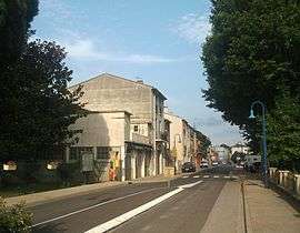 The main street in Saint-Féliu-d'Avall | ||
| ||
 Saint-Féliu-d'Avall Location within Occitanie region  Saint-Féliu-d'Avall | ||
| Coordinates: 42°40′57″N 2°44′21″E / 42.6825°N 2.7392°ECoordinates: 42°40′57″N 2°44′21″E / 42.6825°N 2.7392°E | ||
| Country | France | |
| Region | Occitanie | |
| Department | Pyrénées-Orientales | |
| Arrondissement | Perpignan | |
| Canton | La Vallée de la Têt | |
| Intercommunality | Perpignan Méditerranée Métropole | |
| Government | ||
| • Mayor (2014–2020) | Robert Taillant | |
| Area1 | 10.79 km2 (4.17 sq mi) | |
| Population (2014)2 | 2,633 | |
| • Density | 240/km2 (630/sq mi) | |
| Time zone | UTC+1 (CET) | |
| • Summer (DST) | UTC+2 (CEST) | |
| INSEE/Postal code | 66174 /66170 | |
| Elevation |
63–114 m (207–374 ft) (avg. 87 m or 285 ft) | |
|
1 French Land Register data, which excludes lakes, ponds, glaciers > 1 km2 (0.386 sq mi or 247 acres) and river estuaries. 2 Population without double counting: residents of multiple communes (e.g., students and military personnel) only counted once. | ||
.svg.png)
Saint-Féliu-d'Avall (Catalan: Sant Feliu d'Avall) is a commune in the Pyrénées-Orientales department in southern France.
Geography
Saint-Féliu-d'Avall is located in the canton of La Vallée de la Têt and in the arrondissement of Perpignan.

Map of Saint-Féliu-d'Avall and its surrounding communes
Population

Population 1962-2008
See also
References
| Wikimedia Commons has media related to Saint-Féliu-d'Avall. |
This article is issued from
Wikipedia.
The text is licensed under Creative Commons - Attribution - Sharealike.
Additional terms may apply for the media files.