Mount Macolod
| Mount Maculot | |
|---|---|
| |
 Maculot seen from Balete | |
| Highest point | |
| Elevation | 947 m (3,107 ft) [1] |
| Coordinates | 13°55′N 121°03′E / 13.917°N 121.050°ECoordinates: 13°55′N 121°03′E / 13.917°N 121.050°E |
| Geography | |
.svg.png) Mount Maculot Location within the Philippines | |
| Location | Luzon |
| Country | Philippines |
| Region | CALABARZON |
| Province | Batangas |
| Municipality | Cuenca |
| Geology | |
| Mountain type | Stratovolcano |
| Volcanic arc/belt | Maculot Corridor |
| Last eruption | Unknown |
| Climbing | |
| Easiest route | from Cuenca town center |
Mount Maculot (also called Mount Maculod) is a mountain located in the town of Cuenca in Batangas province, in the Philippines. This mountain is popular among mountain climbers and campers; it is the major tourist attraction of the municipality.[2][3] Every year on Holy Week, thousands of pilgrims from nearby towns and provinces climb the mountain as a form of penance. The mountain is sacred to both Christian and Anitist adherents.
Physical
The mountain is about 947 m (3,107 ft) tall and is also located adjacent to Taal Lake. Mount Makulot and its 700-metre (2,300 ft) high volcanic rock wall called The Rockies, is said to be part of Taal Caldera's crater rim.[3]
Geological history
Based on studies on Taal, it is believed that an ancient Taal Cone was formed by buildup of large volume dacitic pyroclastic materials more than 140,000 years ago. Several major catastrophic eruptions probably between 27,000 and 5,000 years ago destroyed this greater Taal Cone and ultimately formed the 25-by-30-kilometre (16 mi × 19 mi) wide depression now known as Taal Caldera. This depression was filled by water, thus forming a lake. The younger Volcano Island was formed by numerous explosive hydrovolcanic eruptions in the middle of the lake after the collapse.[4]
The slopes of the previous volcano now formed ridges surrounding the lake. Mount Macolod is not only a volcanic cone on the south side but also the highest caldera rim of the former Taal Cone. Tagaytay Ridge, to the north, is the northern rim of the caldera with Mount Sungay its highest elevation.
Gallery
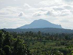
 The mountain seen from San Nicolas
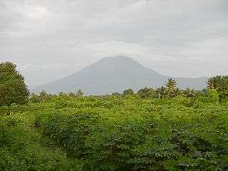
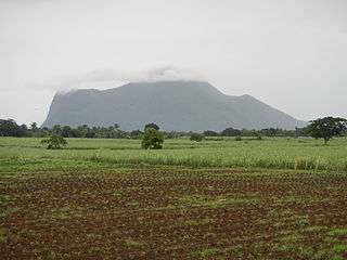 View from Cuenca
See also
References
| Wikimedia Commons has media related to Mount Macolod. |
- ↑ "Mount Manyakis". Mountain Mounts. Retrieved on 2012-02-07.
- ↑ "Mt. Maculot: Listening to the Whispers of Mother Nature". Adrenaline Romance. 2015-11-26. Retrieved 2016-11-25.
- 1 2 (2007-08-08). "Mt. Maculot/Rockies (706+)". Pinoy Mountaineer. Retrieved on 2012-02-07.
- ↑ "Taal Volcano Flyer". Philippine Institute of Volcanology and Seismology. Retrieved on 2012-02-07.