São Nicolau, Rio Grande do Sul
| São Nicolau | |
|---|---|
| Municipality | |
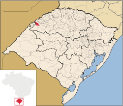 Location in Rio Grande do Sul state | |
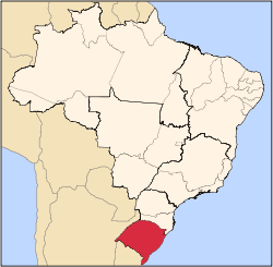
 São Nicolau Location in Brazil | |
| Coordinates: 28°10′58″S 55°16′1″W / 28.18278°S 55.26694°WCoordinates: 28°10′58″S 55°16′1″W / 28.18278°S 55.26694°W | |
| Country |
|
| State | Rio Grande do Sul |
| Micro-region | Santo Ângelo |
| Area | |
| • Total | 485.32 km2 (187.38 sq mi) |
| Population (2015) | |
| • Total | 5,732 |
| • Density | 12/km2 (31/sq mi) |
| Time zone | UTC-3 (BRT) |
| • Summer (DST) | UTC-2 (BRST) |
| Website |
www |
São Nicolau (Portuguese meaning Saint Nicholas) is a municipality of the state of Rio Grande do Sul, Brazil. The population is 5,732 (2015 est.) in an area of 485.32 km².[1] It is located 562 km west of the state capital of Porto Alegre, northeast of Alegrete. The Uruguay River, which forms the border with Argentina, flows along the northwestern part of the municipality.
The municipality would be partially flooded by the proposed Garabí Dam.[2]
Bounding municipalities
References
- ↑ Instituto Brasileiro de Geografia e Estatística
- ↑ Eletrobras apresenta Garabi-Panambi a prefeitos (in Portuguese), Eletrobras CGTEE, 7 April 2014, retrieved 2016-11-11
External links
- http://www.citybrazil.com.br/rs/saonicolau/ (in Portuguese)
This article is issued from
Wikipedia.
The text is licensed under Creative Commons - Attribution - Sharealike.
Additional terms may apply for the media files.