Turuçu
| Turuçu | |
|---|---|
| Municipality | |
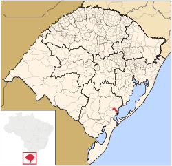 Location in Rio Grande do Sul state | |
 Turuçu Location in Brazil | |
| Coordinates: 31°25′8″S 52°10′30″W / 31.41889°S 52.17500°WCoordinates: 31°25′8″S 52°10′30″W / 31.41889°S 52.17500°W | |
| Country |
|
| State | Rio Grande do Sul |
| Meso-region | Sudeste Rio-Grandense |
| Micro-region | Pelotas |
| Area | |
| • Total | 253.64 km2 (97.93 sq mi) |
| Elevation | 30 m (100 ft) |
| Population (2015) | |
| • Total | 3,596 |
| • Density | 14/km2 (37/sq mi) |
| Time zone | UTC-3 (BRT) |
| • Summer (DST) | UTC-2 (BRST) |
| Website |
www |
Turuçu is a Brazilian municipality in the southeastern part of the state of Rio Grande do Sul. It is nicknamed the National Capital of the Chili Pepper (Capital Nacional da Pimenta Vermelha). The population is 3,596 (2015 est.) in an area of 253.64 km².[1] The name comes from a local Native American language. It lies close to the Lagoa dos Patos, a lagoon connected with the Atlantic Ocean.
References
External links
This article is issued from
Wikipedia.
The text is licensed under Creative Commons - Attribution - Sharealike.
Additional terms may apply for the media files.