Santana do Livramento
| Santana do Livramento | |
|---|---|
| City | |
 | |
|
Nickname(s): Livramento (Deliverance) Fronteira da Paz (Border of Peace) | |
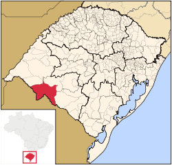 Location of Santana do Livramento | |
| Coordinates: Coordinates: 30°52′39″S 55°31′59″W / 30.87750°S 55.53306°W | |
| Country |
|
| Region | South |
| State |
|
| Founded | July 30, 1823 |
| Government | |
| • Mayor | Solimar Charopen Gonçalves (PDT) |
| Area | |
| • Total | 6,950,370 km2 (2,683,550 sq mi) |
| Elevation | 208 m (682,415 ft) |
| Population (2014) | |
| • Total | 83,324 |
| • Density | 11,99/km2 (4,62/sq mi) |
| Time zone | UTC-3 (UTC-3) |
| • Summer (DST) | UTC-2 (UTC-2) |
| Area code(s) | +55 (55) |
| Website | Santana do Livramento, RS |
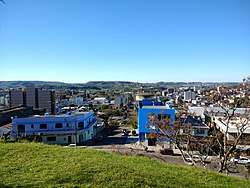
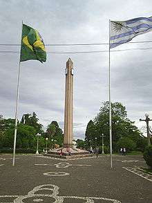
Santana do Livramento is a city in the state of Rio Grande do Sul, Brazil. It is located along the border with the city of Rivera, Uruguay, forming together an international city of almost 170,000 inhabitants.
In 2009, the city was officially declared by the Brazilian government as the symbolic city of Brazilian integration with the Mercosur member states.[1]
History
The first known occupants of the region of the current municipality were the charrúa and minuane indigenous. Then came Spanish Jesuits, then throughout the 19th century came Portuguese and Italian immigrants. In 1810, the political instability that would lead to the independence of the Spanish colonies in the Platina Basin led to the arrival of Portuguese troops to the region, in order to protect the Portuguese-Spanish border. These troops, commanded by Diogo de Sousa, Count of Rio Pardo, began the present city of Santana do Livramento, through the construction of a chapel dedicated to the homonymous saint. The permanent Portuguese settlement of the region began with the donation of sesmarias made by the Marquês of Alegrete in 1814. Founded the city on July 30, 1823, it was elevated to the category of municipality in 1857, emancipating itself from Alegrete.
Santana do Livramento is located on the Brazilian border with Uruguay; on the other side of the dry divide (an urban street), is the Uruguayan city of Rivera. It is one of the oldest municipalities, and the second largest in the territorial extension of the state of Rio Grande do Sul. It went through periods of great prosperity, when large woolen mills, refrigerators, social organizations and soccer clubs were emerging. Slowly, the economy has been fading, for many reasons, among which can be cited: isolation (distance from other expressive economic centers), centralist vision (in politics, industry, commerce, territorial organization), economic option agriculture and trade, without emphasis on the development of industry, which plays the role of "bridge" between the aforementioned activities.
Livramento records more than 100 kilometers of dry border border with Uruguay.
In 1912, the city started to have the first train station in Brazil with international traffic, between Santana do Livramento and Rivera, Uruguay, making trains connect Rio de Janeiro and São Paulo to Montevideo and Buenos Aires. Currently, the International Train is disabled.[2]
The area of the municipality located between the Quaraí River and the Arroio Invernada (called the Rincão de Artigas) has been claimed by the government of Uruguay since 1934.
Overview
It is 208 meters above sea level, and is 498 km from its capital city (Porto Alegre). The population in 2010 was 82,513 inhabitants in an area of 6,950.37 km². Santana do Livramento was founded on July 30, 1823 and in 1857 was emancipated from Alegrete as a city. The economy is mainly farming, cattle, leather goods and Viniculture Commerce. The city also crosses the 31st parallel, making it an ideal area for wine production. The two main wineries are Almaden and Santa Colina.
Many tourists come to Livramento to visit the duty-free shops in its neighboring city Rivera.
Rural tourism is also an attractive option in Santana do Livramento.
Language: Portuguese and Portunhol (a mixture of Spanish and Portuguese).
Events:
- International kite fair;
- 20 September day, when the gaúchos commemorate the Ragamuffin War;
- Festival of lamb and wine.
Ibirapuitã Park, on BR 293, lies about ten kilometers from the city.
The border community is unusual in that inhabitants from both Livramento (Brazil) and Rivera (Uruguay) are free to move anywhere throughout the twin city community. It is easy for one to get lost in the suburbs and not know whether they are in Brazil or Uruguay. Customs and checkpoints are located outside the cities.
Religion
The majority of the population declares themselves Roman Catholic. However, in the last few years there has been a great increase in the number of Protestants in the Pentecostal and traditional aspects, especially in: Assembleia de Deus Church, Metodista Wesleyana Church, Evangelho Quadrangular Church, Deus é Amor, Batista Nacional Church, Internacional da Graça de Deus Church, Congregação Cristã no Brasil, among others.
Other lines, also present that are part of Brazilian religiosity: Umbanda and Spiritism by Allan Kardec. Within the plurality of Brazil, Santana do Livramento also have small groups of other creeds as Muslims, originating from countries of the Middle East and Hindus, coming from India.
Climate
The climate in Santana do Livramento is humid subtropical (Cfa, according to the Köppen climate classification). The temperature is mild in winter and hot in summer.
The warmest month is January, with an average temperature of 24.9 °C (76.8 °F), while the coldest month is July, with an average of 12.5 °C (54.5 °F). The average annual temperature is 18.4 °C (65.1 °F) and the average annual rainfall is 1,467 millimetres (57.8 in).
| Climate data for Santana do Livramento, Brazil | |||||||||||||
|---|---|---|---|---|---|---|---|---|---|---|---|---|---|
| Month | Jan | Feb | Mar | Apr | May | Jun | Jul | Aug | Sep | Oct | Nov | Dec | Year |
| Average high °C (°F) | 31.6 (88.9) |
31 (88) |
28.4 (83.1) |
23.8 (74.8) |
20.6 (69.1) |
18 (64) |
17.8 (64) |
19.8 (67.6) |
21 (70) |
23.4 (74.1) |
27.6 (81.7) |
30.1 (86.2) |
24.4 (76) |
| Average low °C (°F) | 18.3 (64.9) |
17.8 (64) |
16 (61) |
12.3 (54.1) |
9.3 (48.7) |
8.1 (46.6) |
7.2 (45) |
8.2 (46.8) |
9.9 (49.8) |
11.9 (53.4) |
13.9 (57) |
15.9 (60.6) |
12.4 (54.3) |
| Average precipitation mm (inches) | 132 (5.2) |
131 (5.16) |
133 (5.24) |
147 (5.79) |
114 (4.49) |
113 (4.45) |
106 (4.17) |
96 (3.78) |
137 (5.39) |
150 (5.91) |
106 (4.17) |
102 (4.02) |
1,467 (57.77) |
| Source: Climate-data.org[3] | |||||||||||||
Education
Higher education
Santana do Livramento has seven higher education institutions, three of which are private: University of the Campanha Region, Paulista/Cultural University and Castelo Branco/Exattus University (the last two, distance learning).
The public ones are: State University of Rio Grande do Sul, Federal University of Santa Maria, Open University of Brazil and Federal University of Pampa.
Transport
There is a break of gauge station where the railways of Brazil and Uruguay meet.
Santana do Livramento has an airport but scheduled flights to the Brazilian city usually use Pres. Gral. Óscar D. Gestido International Airport in neighboring Rivera, Uruguay.
References
External links
| Wikivoyage has a travel guide for Santana do Livramento. |