Garruchos, Rio Grande do Sul
| Garruchos | |
|---|---|
| Municipality | |
 Location in Rio Grande do Sul state | |
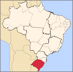
 Garruchos Location in Brazil | |
| Coordinates: 28°11′2″S 55°38′20″W / 28.18389°S 55.63889°WCoordinates: 28°11′2″S 55°38′20″W / 28.18389°S 55.63889°W | |
| Country |
|
| State | Rio Grande do Sul |
| Meso-region | Sudoeste Rio-Grandense |
| Micro-region | Campanha Ocidental |
| Area | |
| • Total | 799.85 km2 (308.82 sq mi) |
| Population (2015) | |
| • Total | 3,219 |
| • Density | 4.0/km2 (10/sq mi) |
| Time zone | UTC-3 (BRT) |
| • Summer (DST) | UTC-2 (BRST) |
| Postal code | 97685-xxx |
| Website |
www |
Garruchos is a municipality in the western part of the state of Rio Grande do Sul, Brazil. The population is 3,219 (2015 est.) in an area of 799.85 km².[1] Its elevation is 69 m by the Uruguay River. It is located 627 km west of the state capital of Porto Alegre, northeast of Alegrete.
The town is situated by the Uruguay River which forms the border with Argentina to the west; an Argentine settlement with the same name, Garruchos, is on the other side.
The municipality would be partially flooded by the proposed Garabí Dam.[2]
References
- ↑ Instituto Brasileiro de Geografia e Estatística
- ↑ Eletrobras apresenta Garabi-Panambi a prefeitos (in Portuguese), Eletrobras CGTEE, 7 April 2014, retrieved 2016-11-11
External links
- http://www.citybrazil.com.br/rs/garruchos/ (in Portuguese)
This article is issued from
Wikipedia.
The text is licensed under Creative Commons - Attribution - Sharealike.
Additional terms may apply for the media files.