Giruá
| Giruá | |
|---|---|
| Municipality | |
 Location in Rio Grande do Sul state | |
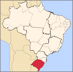
 Giruá Location in Brazil | |
| Coordinates: 28°1′40″S 54°21′0″W / 28.02778°S 54.35000°WCoordinates: 28°1′40″S 54°21′0″W / 28.02778°S 54.35000°W | |
| Country |
|
| State | Rio Grande do Sul |
| Micro-region | Santo Ângelo |
| Area | |
| • Total | 855.92 km2 (330.47 sq mi) |
| Population (2015) | |
| • Total | 17,198 |
| • Density | 20/km2 (52/sq mi) |
| Time zone | UTC-3 (BRT) |
| • Summer (DST) | UTC-2 (BRST) |
| Website |
www |
Giruá is a municipality in the northern part of the state of Rio Grande do Sul, Brazil. The population is 17,198 (2015 est.) in an area of 855.92 km².[1] It is located 474 km west of the state capital of Porto Alegre, northeast of Alegrete.
Bounding municipalities
Economy
Because of its rich volcanic soil, agriculture is important in Giruá, notably soy production. Its nickname is the Capital of Productivity. Other important crops are maize, wheat, sunflower and linseed.
History
The area of Giruá was first inhabited by the Guarani people, and in the 17th century Jesuit missions arrived. The name Giruá comes from jerivá, an indigenous word for the fruit of the butia palm.
References
External links
- http://www.citybrazil.com.br/rs/girua/ (in Portuguese)
This article is issued from
Wikipedia.
The text is licensed under Creative Commons - Attribution - Sharealike.
Additional terms may apply for the media files.