Rouvray, Côte-d'Or
| Rouvray | ||
|---|---|---|
| Commune | ||
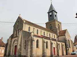 The church in Rouvray | ||
| ||
 Rouvray Location within Bourgogne-Franche-Comté region  Rouvray | ||
| Coordinates: 47°25′31″N 4°06′16″E / 47.4253°N 4.1044°E / 47.4253; 4.1044Coordinates: 47°25′31″N 4°06′16″E / 47.4253°N 4.1044°E / 47.4253; 4.1044 | ||
| Country | France | |
| Region | Bourgogne-Franche-Comté | |
| Department | Côte-d'Or | |
| Arrondissement | Montbard | |
| Canton | Semur-en-Auxois | |
| Intercommunality | Morvan-Vauban | |
| Government | ||
| • Mayor (2008–2014) | Christian Nault | |
| Area1 | 9.48 km2 (3.66 sq mi) | |
| Population (2008)2 | 642 | |
| • Density | 68/km2 (180/sq mi) | |
| Time zone | UTC+1 (CET) | |
| • Summer (DST) | UTC+2 (CEST) | |
| INSEE/Postal code | 21531 /21530 | |
| Elevation | 308–401 m (1,010–1,316 ft) | |
|
1 French Land Register data, which excludes lakes, ponds, glaciers > 1 km2 (0.386 sq mi or 247 acres) and river estuaries. 2 Population without double counting: residents of multiple communes (e.g., students and military personnel) only counted once. | ||
.svg.png)
Rouvray is a commune in the Côte-d'Or department in eastern France.
Population
| Historical population | ||
|---|---|---|
| Year | Pop. | ±% |
| 1962 | 545 | — |
| 1968 | 576 | +5.7% |
| 1975 | 445 | −22.7% |
| 1982 | 555 | +24.7% |
| 1990 | 601 | +8.3% |
| 1999 | 580 | −3.5% |
| 2008 | 642 | +10.7% |
Environment
Rouvray lies within the Morvan Regional Natural Park.
See also
References
| Wikimedia Commons has media related to Rouvray (Côte-d'Or). |
This article is issued from
Wikipedia.
The text is licensed under Creative Commons - Attribution - Sharealike.
Additional terms may apply for the media files.