Uzhhorod
| Uzhhorod Ужгород | |||
|---|---|---|---|
| City of regional significance | |||
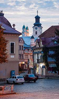
 A panoramic view of Uzhhorod and the Greek Catholic Cathedral in the centre of the image | |||
| |||
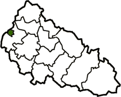 Map of Zakarpattia Oblast with Uzhhorod. | |||
 Uzhhorod Location of Uzhhorod  Uzhhorod Uzhhorod (Ukraine) | |||
| Coordinates: 48°37′26″N 22°17′42″E / 48.62389°N 22.29500°ECoordinates: 48°37′26″N 22°17′42″E / 48.62389°N 22.29500°E | |||
| Country |
| ||
| Oblast |
| ||
| Raion | Uzhhorod Municipality | ||
| Founded | 9th century | ||
| Government | |||
| • Mayor | Bohdan Andriyiv (Revival)[1] | ||
| Area | |||
| • Total | 65 km2 (25 sq mi) | ||
| Elevation | 169 m (554 ft) | ||
| Population (2016) | |||
| • Total | 115,163 | ||
| • Density | 3,662/km2 (9,480/sq mi) | ||
| Time zone | UTC+2 (EET) | ||
| • Summer (DST) | UTC+3 (EEST) | ||
| Postal code | 88000 | ||
| Area code(s) | +380,312 | ||
| Sister cities | Békéscsaba, Nyíregyháza, Moscow, Orel, Pula, Corvallis, Darmstadt, Košice | ||
| Climate | Cfb | ||


.jpg)
Uzhhorod (Ukrainian: У́жгород, translit. Užhorod, [ˈuʒɦɔrɔd]) previously and historically known as Ungvár (in Hungarian; German: Ungwar) is a city located in western Ukraine, at the border with Slovakia and near the border with Hungary. It is the administrative center of Zakarpattia Oblast (region), as well as the administrative center of the surrounding Uzhhorod Raion (district) within the oblast. The city itself is also designated as city of oblast significance, a status equivalent to that of a raion, and does not belong to Uzhhorod Raion. Population: 115,163 (2016 est.)[2].
Name
The city gets its name from the Uzh River, which divides the city into two parts (the old and new sections), while horod (город) is Rusyn for city, coming from Old Slavonic grad (градъ). However, this name is a recent construct, and has been used only since the beginning of the 20th century. Before then, the city was known as Ungvár, also spelled Ongvár, Hungvár, and Unguyvar, a name derived from Ung, the Hungarian name for the Uzh (as well as the surrounding county) and vár, meaning castle, fort.
It is also known by several alternative names: Czech: Užhorod; Slovak: Užhorod; German: Ungwar, Ungarisch Burg; Polish: Użhorod; Romanian: Ujgorod.
History
![]()
![]()
![]()
![]()
![]()
![]()
![]()
![]()
Early history
The best known of the first city founders are early Slavs. One of their tribes – White Croats – settled the area of the modern Uzhhorod in the second half of the first millennium AD. During the 9th century a fortified castle changed into a fortified early feudal town-settlement, which became the centre of a new Slavonic principality, at the head of which was a mythical prince Laborets, who was vassal of Great Moravia. Great Moravia, according to historians and experts did not extend as far east as Uzhgorod, in fact it was west of what is now the City of Bratislava, Slovakia.
In 895 AD Hungarian tribes, headed by their leader Árpád, stormed the Hungvar fortress. The forces were not equal and Laborets was defeated and beheaded on the banks of the river that still carries his name. Again, this is mythical. There was not much of a settlement when the Magyar tribes arrived, having left Kiev (then known as Kevevara) and encountering no resistance.
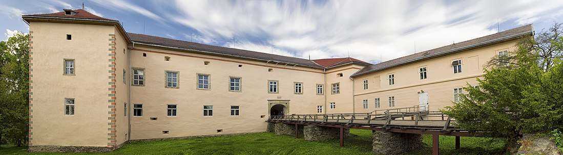
After the arrival of the Hungarians, the small town began to extend its borders. In 1241–1242 the Mongols of Batu Khan burnt the settlement. In the early 14th century Uzhhorod showed strong resistance to the new Hungarian rulers of the Anjou dynasty. Although the majority of inhabitants were Hungarians, they wanted more freedom. From 1318 for 360 years, the Drugeths (Italian counts) owned the town. During that period Philip Drugeth built Uzhhorod Castle. The name Ungvar in Hungarian meaning Castle of Ung. Together with the castle the city began to grow. From 1430, Uzhhorod became a free royal town.
During the 16–17th centuries there were many handicraft corporations in Uzhhorod. In this period the city was engaged in the religious fight between primarily Protestant Transylvania and Catholic Austria. In 1646 the Ungvar Union was proclaimed and the Greek-Catholic church was established in Subcarpathia, in a ceremony held in the Ungvar castle by the Vatican Aegis. In 1707 Ungvar was the residence of Ferenc II Rákóczi, leader of the national-liberation war of Hungarians against Vienna.
The beginning of the 19th century was characterized by economic changes, including the first factories in the city. The greatest influence on Ungvar among the political events of the 19th century was made by the Hungarian Revolution of 1848-1849, during which the native Hungarian nobility sought both get free of the Austrian Empire and to have authority over their own people. 27 March 1848 was officially celebrated in the city as the overthrow of the monarchy in Hungary. It is now celebrated in Hungary on the 15th of March.
In 1872 the first railway line opened, linking the city to the important railway junction of Chop then known as Csap.
Twentieth century
According to the 1910 census, the city had 16,919 inhabitants, of which 13,590 (80.3%) were Magyars, 1,219 (7.2%) Slovaks, 1,151 (6.8%) Germans, 641 (3.8%) Rusyns and 1.6% Czechs.[4] Since Jews were not counted as ethnicity (as defined by language), rather only religious group, this Austrian-Hungarian census does not specifically mention the Jewish population, which was significant, and consisted of about 31% in 1910.[5] In the same time, the municipal area of the city had a population composed of 10,541 (39.05%) Hungarians, 9,908 (36.71%) Slovaks, and 5,520 (20.45%) Rusyns.[6]
The First World War slowed down the tempo of city development. On 10 September 1919 Subcarpathia was officially allocated to the Republic of Czechoslovakia. Uzhhorod became the administrative center of the territory. During these years Uzhhorod developed into an architecturally modern city. After the Treaty of Trianon 1920, Uzhhorod became part of the eastern half of the new Czecho-Slovak state.
After the First Vienna Award in 1938, Uzhhorod was given back to Hungary from which it was forcibly separated after WWI. The inhabitants did not wish to become a part of Czechoslovakia but their wishes were not honored. The city reverted to its original name of Ungvar, the name that the city had for almost 1000 years.
In 1941 the Jewish population reached 9,576. On 19 March 1944, Germans troops entered the city. They established a Judenrat (Jewish council) and set up 2 ghettos, at the Moskovitz brickyard and at the Gluck lumberyard. During May 1944, all Jews were deported to Auschwitz in 5 different transports and subsequently murdered. Only a few hundred Jews survived.[7]
On 27 October 1944 the city was captured by the troops of the 4th Ukrainian Front of the Red Army. Thousands of ethnic Hungarians were killed, expelled, or else taken to work in Soviet forced labor camps. The Hungarian majority population was decimated in order to strengthen the Soviet and Ukrainian right to the city.
This period brought significant changes. At the outskirts of Uzhhorod new enterprises were constructed and the old enterprises were renewed. On 29 June 1945 Subcarpathian Ukraine was annexed by the Soviet Union and became a westernmost part of the Ukrainian SSR. That year the Uzhhorod State University (now Uzhhorod National University) was also opened. Since January 1946 Uzhhorod was the center of newly formed Zakarpatska oblast.
Since 1991 Uzhhorod has become one of 24 regional capitals within Ukraine. Of these, Uzhhorod is the smallest and westernmost.
In 2002, after some controversy, a bust of Tomáš Masaryk, Czechoslovakia's first president, was unveiled in a main square of the city. A similar bust was unveiled in 1928 on the 10th anniversary of Czechoslovak independence, but was removed by the Hungarians when they took over the region in 1939.
Climate
Uzhhorod has a humid continental climate (Köppen: Dfb) with cool to cold winters and warm summers. The coldest month is January with an average temperature of −1.7 °C (28.9 °F) while the warmest month is July with an average temperature of 20.9 °C (69.6 °F).[8] The coldest temperature ever recorded is −28.2 °C (−18.8 °F) and the warmest temperature was 38.6 °C (101.5 °F). Average annual precipitation is 748 millimetres (29.4 in), which is evenly distributed throughout the year though the summer months have higher precipitation.[8] On average, Uzhhorod receives 1950 hours of sunshine per year[9]

| Climate data for Uzhhorod | |||||||||||||
|---|---|---|---|---|---|---|---|---|---|---|---|---|---|
| Month | Jan | Feb | Mar | Apr | May | Jun | Jul | Aug | Sep | Oct | Nov | Dec | Year |
| Record high °C (°F) | 13.3 (55.9) |
17.2 (63) |
25.4 (77.7) |
29.7 (85.5) |
33.4 (92.1) |
35.0 (95) |
38.6 (101.5) |
38.4 (101.1) |
35.9 (96.6) |
26.1 (79) |
21.6 (70.9) |
15.6 (60.1) |
38.6 (101.5) |
| Average high °C (°F) | 1.3 (34.3) |
3.7 (38.7) |
9.8 (49.6) |
16.7 (62.1) |
22.0 (71.6) |
24.6 (76.3) |
26.9 (80.4) |
26.6 (79.9) |
21.2 (70.2) |
15.4 (59.7) |
8.2 (46.8) |
2.7 (36.9) |
14.9 (58.8) |
| Daily mean °C (°F) | −1.7 (28.9) |
−0.1 (31.8) |
5.0 (41) |
11.0 (51.8) |
16.1 (61) |
18.8 (65.8) |
20.9 (69.6) |
20.3 (68.5) |
15.5 (59.9) |
10.3 (50.5) |
4.7 (40.5) |
−0.2 (31.6) |
10.1 (50.2) |
| Average low °C (°F) | −4.8 (23.4) |
−3.7 (25.3) |
0.6 (33.1) |
5.5 (41.9) |
10.4 (50.7) |
13.1 (55.6) |
15.0 (59) |
14.5 (58.1) |
10.3 (50.5) |
5.7 (42.3) |
1.4 (34.5) |
−3.0 (26.6) |
5.4 (41.7) |
| Record low °C (°F) | −28.2 (−18.8) |
−26.3 (−15.3) |
−17.5 (0.5) |
−6.2 (20.8) |
−4.4 (24.1) |
1.5 (34.7) |
5.4 (41.7) |
4.4 (39.9) |
−2.2 (28) |
−9.3 (15.3) |
−21.8 (−7.2) |
−24.7 (−12.5) |
−28.2 (−18.8) |
| Average precipitation mm (inches) | 53 (2.09) |
50 (1.97) |
43 (1.69) |
49 (1.93) |
74 (2.91) |
76 (2.99) |
80 (3.15) |
74 (2.91) |
72 (2.83) |
56 (2.2) |
57 (2.24) |
68 (2.68) |
752 (29.61) |
| Average rainy days | 11 | 10 | 13 | 15 | 16 | 16 | 15 | 13 | 13 | 13 | 14 | 13 | 162 |
| Average snowy days | 14 | 12 | 5 | 1 | 0.03 | 0 | 0 | 0 | 0 | 0.3 | 5 | 12 | 49 |
| Average relative humidity (%) | 82 | 76 | 67 | 62 | 65 | 68 | 67 | 69 | 73 | 76 | 80 | 83 | 72 |
| Mean monthly sunshine hours | 59 | 87 | 142 | 190 | 246 | 249 | 274 | 253 | 192 | 151 | 63 | 46 | 1,952 |
| Source #1: Pogoda.ru.net[8] | |||||||||||||
| Source #2: NOAA (sun, 1961–1990)[9] | |||||||||||||
Demographics
According to the Ukrainian 2001 census, the population of Uzhhorod included:[10]
- Ukrainians (77.8%)
- Russians (9.6%)
- Hungarians (6.9%)
- Slovaks (2.2%)
- Romani (1.5%)
Transportation
Uzhhorod is served by Uzhhorod railway station and has railway connection with Chop (further to Hungary and Slovakia) and Lviv (further to Kiev).
Uzhhorod is served by Uzhhorod International Airport that currently does not have any inbound or outbound flights.
Sport
The city was home to the SC Rusj Uzhorod football club from 1925. Contemporary side FC Hoverla Uzhhorod made their debut in the Ukrainian Premier League in 2001.
International relations
Twin towns – Sister cities
Uzhhorod is currently twinned with:
Notable residents
- Vladimir Koman, a Ukrainian-born, Hungarian football player
- János Erdélyi, a Hungarian poet, critic, author, philosopher and ethnographist
- Shlomo Ganzfried, an Orthodox rabbi and posek
- Józef Kasparek, a Polish lawyer, historian and political scientist
- Mikhail Kopelman, a violinist
- Joseph L. Kun, emigrated to the United States, became a judge
- Samuel Lipschütz, a chess player and author
- Yozhef Sabo, a Soviet football player of Hungarian ethnicity
- Avhustyn Voloshyn, a Subcarpathian politician, teacher, and essayist
- Anatoly Zatin, a composer, pianist and conductor
- Gregory Zatkovich, first governor of Carpathian Ruthenia
- Puchyna Mariya, Miss Ukraine 2007
- Andriy Zayats, diplomat, State Secretary
See also
References
- ↑ Vidrodzhennia Party's Andriyiv wins Uzhgorod mayoral election, Interfax-Ukraine (16 November 2015)
- ↑ "Чисельність наявного населення України (Actual population of Ukraine)" (PDF) (in Ukrainian). State Statistics Service of Ukraine. Retrieved 19 July 2016.
- ↑ 'The Great Experiment: The Story of Ancient Empires, Modern States, and the Quest for a Global Nation' by Strobe Talbott, 2008 (page 243)
- ↑ Atlas and Gazetteer of Historic Hungary 1914, Talma Kiadó Archived 14 January 2017 at the Wayback Machine.
- ↑ KATZ, Marshall J. "Uzhhorod (Ungvár), Ukraine KehilaLink". kehilalinks.jewishgen.org. Retrieved 2017-05-08.
- ↑ "Ung County". Genealogy Online. Retrieved 17 March 2007.
- ↑ "Uzhorod". Kehilalinks. Retrieved 22 March 2017.
- 1 2 3 "Pogoda.ru.net". Weather and Climate for Uzhhorod (in Russian). Retrieved 8 February 2017.
- 1 2 "Uzgorod (Uzhhorod) Climate Normals 1961–1990". National Oceanic and Atmospheric Administration. Retrieved 8 February 2017.
- ↑ "Zakarpattia Region". Ukrainian 2001 census. Archived from the original on 11 September 2007. Retrieved 17 March 2007.
- ↑ "Städtepartnerschaften und Internationales". Büro für Städtepartnerschaften und internationale Beziehungen (in German). Retrieved 26 July 2013.
- ↑ "Twin cities of the City of Kosice". Magistrát mesta Košice, Tr. Retrieved 27 July 2013.
- ↑ "Krosno Official Website – Partner Cities" (in Polish). Urząd Miasta Krosna. Retrieved 23 October 2008.
- ↑ "Jarosław Official Website – Partner Cities" (in Polish). Urząd Miasta Jarosław. Ul. Rynek 1, 37–500 Jarosław. Retrieved 23 October 2008.
- ↑ "Protocol de colaborare Ujgorod-Satu Mare" (in Romanian). www.satu-mare.ro. Retrieved 27 June 2009.
External links
| Raions | |||||
|---|---|---|---|---|---|
| Cities |
| ||||
| |||||
| Oblasts | |
|---|---|
| Cities with special status | |
| Autonomous republic | |
| Administrative centers | |
1Claimed and controlled by Russia as the Republic of Crimea and the Federal City of Sevastopol 2Regions are nearly controlled by Pro-Russian seperatists states of Donetsk People's Republic and Luhansk People's Republic | |