Highway M29 (Ukraine)
| ||||
|---|---|---|---|---|
| Автошлях M29 | ||||
| Route information | ||||
|
Part of | ||||
| Length | 160.7 km (99.9 mi) | |||
| Major junctions | ||||
| North end |
| |||
| South end |
| |||
| Location | ||||
| Regions: | Kharkiv Oblast, Dnipropetrovsk Oblast | |||
| Highway system | ||||
| ||||
M29 is a Ukrainian international highway (M-highway) in eastern Ukraine that runs from Kharkiv to Dnipro parallel to the M18. It is also known as Kharkiv – Dnipropetrovsk auto-magistrale. The entire route is part of European route E105.[1][2]
Main route
Main route and connections to/intersections with other highways in Ukraine.
| Marker | Main settlements | Notes | Highway Interchanges |
|---|---|---|---|
| 0 km | Liubotyn | ||
| Nova Vodolaha | |||
| Oktyabrske | |||
| Natalyne | |||
| 157.9 (160.7)* | Hubynykha |
- - with intersection
Gallery
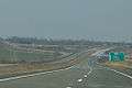 M29 motorway in Kharkiv Oblast
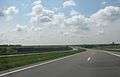 Kharkiv-Dnipro Motorway
See also
References
Sources
- "Про затвердження переліку автомобільних доріг загального користування державного значення". КАБІНЕТ МІНІСТРІВ УКРАЇНИ ПОСТАНОВА від 16 вересня 2015 р. № 712. 2015. Retrieved 2016-02-28. (in Ukrainian)
- "Стан проїзду". Державне агентство автомобільних доріг України. 2016. Archived from the original on 2016-03-10. Retrieved 2016-03-03. (in Ukrainian)
- "Автодороги Украины. Список, маршрут, расстояние". Автодороги Украины. 2016. Retrieved 2016-03-03. (in Russian)
| E-roads in Ukraine | ||
|---|---|---|
| International | ||
| National | ||
| Regional |
| |
| ||
This article is issued from
Wikipedia.
The text is licensed under Creative Commons - Attribution - Sharealike.
Additional terms may apply for the media files.