Highway M02 (Ukraine)
| |
|---|---|
| Автошлях M02 | |
 | |
| Route information | |
|
Part of | |
| Length | 242.5 km (150.7 mi) |
| Major junctions | |
| West end |
|
| East end | Russian border at Bachivsk |
| Location | |
| Regions: | Chernihiv Oblast, Sumy Oblast |
| Highway system | |
| Roads in Ukraine | |
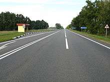
M02 road near Baturyn
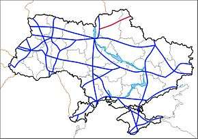
Highway M02 is a Ukraine international highway (M-highway) connecting the M01 near Kipti with Bachivsk on the border with Russia, where it continues as the M3 to Moscow.[1] The entire route is part of European route E101[2] and the section from Hlukhiv to the Russian border is part of European route E391.
The M02 stretches through both the Chernihiv Oblast and the Sumy Oblast and ends at the border checkpoint at Bachivsk which is part of Hlukhiv Raion. Route goes through several historical cities of the Cossack Ukraine of 17th century.
Route
| Marker | Main settlements | Notes | Highway Interchanges |
|---|---|---|---|
| 0 km | near Kipti | ||
| Lykhachiv | T2525 | ||
| Zrub | P67 • T2522 | ||
| 51 | Yunist[lower-alpha 1] | western side | P67 |
| 93 | Borzna | southern side | T2524 |
| Shapovalivka | southern side | T2523 | |
| Palchyky | southern side | T2531 | |
| 126 | Baturyn | P61 | |
| Poliske | T2516 | ||
| 168 | Krolevets | P60 • T1907 • T2503 | |
| 208 | Hlukhiv | northern side | P65 |
| 252 km | Bachivsk / Border (Russia) |
Notes
See also
References
- ↑ "International Highways of Ukraine". euro2012highway.blogspot.com (in Russian).
- ↑ "European highways in Ukraine". euro2012highway.blogspot.com (in Russian).
External links
- International Roads in Ukraine in Russian
- European Roads in Russian
| E-roads in Ukraine | ||
|---|---|---|
| International | ||
| National | ||
| Regional |
| |
| ||
This article is issued from
Wikipedia.
The text is licensed under Creative Commons - Attribution - Sharealike.
Additional terms may apply for the media files.