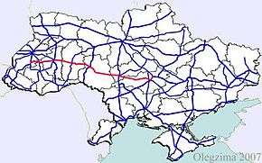
Highway M12 (Ukraine)
| ||||
|---|---|---|---|---|
| Автошлях M12 | ||||
 | ||||
| Route information | ||||
|
Part of | ||||
| Length |
746.7 km (464.0 mi) 756.1 km (469.8 mi) with city routes | |||
| Major junctions | ||||
| West end |
| |||
|
| ||||
| East end |
| |||
| Location | ||||
| Regions: | Lviv Oblast, Ternopil Oblast, Khmelnytskyi Oblast, Vinnytsia Oblast, Cherkasy Oblast, Kirovohrad Oblast | |||
| Highway system | ||||
| ||||
M12 is a Ukrainian international highway (M-highway) connecting Lviv Oblast to Central Ukraine, where after crossing the Dnieper it continues further as the M04.[1]
General overview
The M12 is a major transnational corridor and along with the M04 combines into E50. The highway is also part of the Gdańsk - Odessa Transportation corridor on the segment from Ternopil to Uman. It is one of the longest routes spanning nearly 800 km (500 mi).
Description
For the entire route from Stryi to Znamianka the M12 is part of the E50, however in Kropyvnytskyi it is also joined by the E584 that travels from Moldova to Poltava.[2]
Main Route
Main route and connections to/intersections with other highways in Ukraine.
| Highway M12 | |||
| Marker | Main settlements | Notes | Highway Interchanges |
|---|---|---|---|
| 0 km | Stryi | ||
| Rohatyn | |||
| Ternopil | Bypass | ||
| Khmelnytskyi | Bypass | ||
| Vinnytsia | Bypass | ||
| Uman | |||
| Kropyvnytskyi | |||
| 746 km | Znamianka | ||
Access routes
The highway passes the following cities going around them, however it has spurred away access routes towards them.
- Vinnytsia 1.4 km (0.87 mi)
- Khmelnytskyi 8 km (5.0 mi)
Gallery
 M12 in Vinnytsia oblast
 M12 in Ternopil Oblast
 M12 highway near Ternopil
 M12 junction in Ternopil
See also
References
External links
- International Roads in Ukraine in Russian
- European Roads in Russian
