Ranisankail Upazila
| Ranisonkail রাণীশনকৈল | |
|---|---|
| Upazila | |
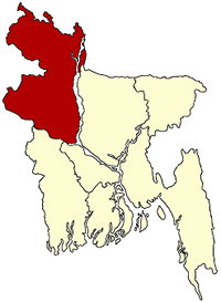
 Ranisonkail Location in Bangladesh | |
| Coordinates: 25°53.3′N 88°15.1′E / 25.8883°N 88.2517°ECoordinates: 25°53.3′N 88°15.1′E / 25.8883°N 88.2517°E | |
| Country |
|
| Division | Rangpur Division |
| District | Thakurgaon District |
| Area | |
| • Total | 287.59 km2 (111.04 sq mi) |
| Population (1991) | |
| • Total | 156,107 |
| • Density | 540/km2 (1,400/sq mi) |
| Time zone | UTC+6 (BST) |
| Website | Official Map of Ranisankail |
Ranisankail (Bengali: রাণীশংকৈল) is an Upazila of Thakurgaon District in the Division of Rangpur, Bangladesh.[1]
Geography
Ranisankail is one of the ancient areas of Bengal. It lies in the North-east corner of Bangladesh and has a total area of 287.59 km². It lies about 480 km from Dhaka, the capital City of Bangladesh. Ranisankail is bordered by Baliadangi upazila to the north, Pirganj upazila to the east, Haripur uapazila to the west, and India on its south side. The main rivers flowing through Ranisankail are the Kulic, Nagar, and Timai rivers. Land use total: cultivable land, 22405.09 hectares; fallow land, 6115.74; single crop, 30%, double crop, 55%; and treble crop 15%; cultivable land under irrigation, 69%.
Demographics
At the 1991 Bangladesh census, Ranisankail had a population of 156107 inhabitants. Males constitute 51.67% of the population and females 48.33%. The number of adults was 76,136. Ranisankail had an average literacy rate of 25.7% (7+ years), below the national average of 32.4%.[2]
Ranisankail (Town) consists of five mouzas. The area of the town is 13.94 km2. The town has a population of 13521; male 52.09%, female 47.91%; population density per km2 970. Literacy rate among the town people is 36.9%.
Population 156107; male 51.67%, female 48.33%. Muslim 76.23%, Hindu 22.79%, Christian 0.30% and others 0.98%; ethnic nationals: Santal 537 families. Main occupations Agriculture 53.7%, agricultural laborer 28.52%, wage laborer 2.59%, commerce 6.41%, service 2.41% and others 6.37%.
Economy
Land control - Among the peasants, 3.43% are landless, 14.01% marginal, 12.78% small, 64.59% intermediate and 5.19% rich; cultivable land per head 0.13 hectare.
Places of interest
Ranisankail is not only known for its natural environment, but also for its historical places. They include the Khunia Dighi Memorial, Palace of King Tonko Nath, Ramrai Dighi (a pond covering 50 acres), Nekmord Oras mela (Fair of Nekmardon), Nekamard Hazrat Shah Nasiruddin (R) Mazar. Nekmarad Hat. Katihar Hat in Razore village (known for Hindu shib mondir, Rash mela, Extinct Maghi Mela), Kulic river, Gorkoi Nath mondir (Temple-900 Years old), Dharmagar, Banglagar, Shidassory Pond (sida Digi, Bhandagram), Ranisonkail Pilot High School, Ancient Primary School (100 years old) and Rautnagar hat.
Administration
In Ranisankail there are 9 Unions/Wards, 124 Mauzas/Mahallas, and 122 villages.
- Chairman: Md. Ainul Haque Master
- Vice Chairman: Md. Mizanur Rahaman Master
- Woman Vice Chairman: Most. Selina Jahan Lita
- Upazila Nirbahi Officer (UNO): Khondokar Nahid Hassan[3]
Transport
There are some highway bus services from Dhaka to Ranisankail run by companies such as AB Enterprise, Bablu Enterprise, Hanif, Rozina, Shymoli, Rahbar, AK Travels, Keya Poribahan and others. Most of them go from Shamoly, Asadgate, Gabtoli of Dhaka. A bus trip from Dhaka to Ranisankail takes about 9–10 hours. Those buses go through Bangabandhu Jamuna bridge on the Dhaka to Thakurgaon highway road.
Gallery
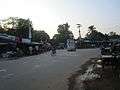 Shibdhighi Three point at Ranisankail
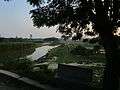 Kulik River at westside of Ranisankail Upazila
References
- ↑ Abu Md. Iqbal Rumi Shah (2012), "Ranisankail Upazila", in Sirajul Islam and Ahmed A. Jamal, Banglapedia: National Encyclopedia of Bangladesh (Second ed.), Asiatic Society of Bangladesh
- ↑ "Population Census Wing, BBS". Archived from the original on 2005-03-27. Retrieved November 10, 2006.
- ↑ "Archived copy". Archived from the original on 2012-02-26. Retrieved 2012-01-20.
| Upazila/Thana: | ||
|---|---|---|