Parbatipur Upazila
| Parbatipur পার্বতীপুর | |
|---|---|
| Upazila | |
 Parbatipur Location in Bangladesh | |
| Coordinates: 25°39′12″N 88°54′56″E / 25.6533°N 88.9155°ECoordinates: 25°39′12″N 88°54′56″E / 25.6533°N 88.9155°E | |
| Country |
|
| Division | Rangpur Division |
| District | Dinajpur District |
| Area | |
| • Total | 395.1 km2 (152.5 sq mi) |
| Population (1991) | |
| • Total | 270,904 |
| • Density | 690/km2 (1,800/sq mi) |
| Time zone | UTC+6 (BST) |
| Website | Official Map of Parbatipur |
Parbatipur (Bengali: পার্বতীপুর) is an upazila (subdistrict) of Dinajpur District in the Rangpur Division, Bangladesh.[1]
Geography
Parbatipur is located at 25°39′12″N 88°54′56″E / 25.6533°N 88.9155°E . It has 53,146 households and a total area 395.1 km².
Demographics

As of the 1991 Bangladesh census, Parbatipur has a population of 270,904. Males constitute 51.46% of the population, and females 48.54%. Upazila's population of people eighteen years old or older is 139,294. Parbatipur has an average literacy rate of 29.7% (7+ years), compared to the national average of 32.4%.Its main attraction is it'sCanttonment.Bir Uttam Sahid Mahabub Shenanibash is located into kholahati.[2]
Administration
Parbatipur has 10 unions, 1 paurasava, 194 mauzas/mahallas, 230 villages and 1 cantonment situated in it.
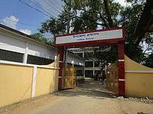
Parbatipur has many Schools and colleges like,
- Parbatipur Adarsha Degree College
- Cantonment Public School & College BUSMS
- Parbatipur Degree College
- Kholahati Degree College
- Cantonment Board High School
- Parbatipur Agriculture College
- Parbatipur Mohila Agriculture College
- Manmathpur Ideal Degree College
- Janankur Pilot High School.
- PArbatipur Girls Pilot High School.
- Parbatipur Govt. Technical School & College
- Parbatipur Balika Biddapit School.
See also
References
| Wikimedia Commons has media related to Parbatipur Upazila. |
- ↑ Ansar Ali Sarker (2012), "Parbatipur Upazila", in Sirajul Islam and Ahmed A. Jamal, Banglapedia: National Encyclopedia of Bangladesh (Second ed.), Asiatic Society of Bangladesh
- ↑ "Population Census Wing, BBS". Archived from the original on 2005-03-27. Retrieved November 10, 2006.
| Upazila/Thana: | ||
|---|---|---|
Capital: Rangpur | ||
| Dinajpur District | 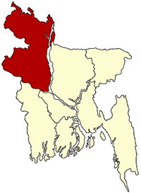 | |
| Gaibandha District | ||
| Kurigram District | ||
| Lalmonirhat District | ||
| Nilphamari District | ||
| Panchagarh District | ||
| Rangpur District | ||
| Thakurgaon District | ||