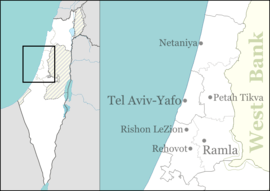
Savyon
Savyon
| |
|---|---|
| Hebrew transcription(s) | |
| • ISO 259 | Sabyon |
| • Also spelled | Savion (unofficial) |
 Savyon | |
| Coordinates: 32°2′50.14″N 34°52′32.56″E / 32.0472611°N 34.8757111°ECoordinates: 32°2′50.14″N 34°52′32.56″E / 32.0472611°N 34.8757111°E | |
| District | Central |
| Founded | 1951 |
| Government | |
| • Type | Local council |
| • Head of Municipality | Motty Landau |
| Area | |
| • Total | 3,746 dunams (3.746 km2 or 1.446 sq mi) |
| Population (2017)[1] | |
| • Total | 3,878 |
| • Density | 1,000/km2 (2,700/sq mi) |
| Name meaning | Common groundsel |
Savyon (Hebrew: סַבְיוֹן, Arabic: سفيون) is a local council in the Central District of Israel, bordering the cities of Kiryat Ono, Petah Tikva, and Yehud. Ranked 10/10 on the Israeli socio-economic scale, it is one of the wealthiest municipalities in Israel. In 2017 it had a population of 3,878.[1]
History
Savyon was founded in 1955 by Africa Israel Investments for senior South African Jewish immigrants. It took the name of a common wildflower, although the first part of its name (sav) means "grandfather", which was appropriate for the residents of the time.[2] Today, Savyon has a young population.
In 2004, the moshav Ganei Yehuda (Hebrew: גַּנֵּי יְהוּדָה) was merged into Savyon.
Both Savyon and Ganei Yehuda are located on the land of the Palestinian village of Al-'Abbasiyya, which became depopulated in the 1948 Arab–Israeli War.[3]
Notable residents
- Mikhail Chernoy—entrepreneur
- Gilad Erdan—current Israeli Minister of Communications.
- Dan Margalit
- Arye Carmon
- Dan Goldstein
- Moshe Arens
- David Mor
- Dan Naveh
- Mody Kidon
- Gideon Patt
- Yair Shamir
- David D'Or
- Maya Dunietz
- Aviv Bushinsky
- Al Schwimmer
- Yaakov Nimrodi
- Ofer Nimrodi
- Yair Nitzani
- Shmuel Flatto-Sharon
References
- 1 2 "List of localities, in Alphabetical order" (PDF). Israel Central Bureau of Statistics. Retrieved August 26, 2018.
- ↑ Vilnai, Ze'ev (1978). "Savyon". Ariel Encyclopedia (in Hebrew). Volume 5. Israel: Am Oved. pp. 5298–99.
- ↑ Khalidi, W. (1992). All That Remains: The Palestinian Villages Occupied and Depopulated by Israel in 1948. Washington D.C.: Institute for Palestine Studies. p. 235. ISBN 0-88728-224-5.