Port Kembla (seaport)
| Port Kembla | |
|---|---|
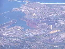 An aerial view of Port Kembla Harbour, looking southeast, 2008. | |
| Location | Illawarra, New South Wales |
| Coordinates | 34°28′S 150°54′E / 34.467°S 150.900°ECoordinates: 34°28′S 150°54′E / 34.467°S 150.900°E |
| Lake type | Cargo port |
| Primary outflows | Tasman Sea, South Pacific Ocean |
| Catchment area | 6.3 km2 (2.4 sq mi) |
| Basin countries | Australia |
| Managing agency | Port Authority of New South Wales |
| Surface area | 1.4 km2 (0.54 sq mi) |
| Average depth | 6.1 m (20 ft) |
| Water volume | 8,439,000 m3 (298,000,000 cu ft) |
| Frozen | never |
| Settlements | Wollongong, Port Kembla |
Port Kembla is a man-made cargo port or artificial harbour, with an outer harbour protected by breakwaters and an inner harbour constructed by dredging,[1] located in the Illawarra region of New South Wales, Australia.
Activities within the port are managed by the Port Authority of New South Wales.
Location and features
Located to the east of the Wollongong suburb of Port Kembla, the harbour of Port Kembla comprises a 8,439 megalitres (298.0×10⁶ cu ft) body of water with a surface area of 1.4 square kilometres (0.54 sq mi) at a dredged average depth of 6.1 metres (20 ft) drawn from a catchment area of 6.3 square kilometres (2.4 sq mi).[2]
The port of Port Kembla was established in the late 1890s to facilitate the export of coal from the mines of the Illawarra region. [3]Diversification of the port facilities during the late-1980s and since, has seen the port to include general and break bulk cargoes, containers and motor vehicle imports, and bulk grain exports.[4]
Regulation of the port rests with a number of federal, state, and local government agencies including the Australian Maritime Safety Authority, the Environment Protection Authority,[5] and Wollongong City Council.
History of the Port
Outer Harbour
Between 1901 and 1937, first an eastern breakwater and then a northern breakwater was constructed, resulting in a large protected and safe anchorage now known as the ‘Outer Harbour’. The eastern breakwater extended from the rocky headland and the eastern breakwater extended from the beach at a point just south of where Tom Thumb Lagoon and Allen’s Creek emptied into the sea.[6] An advantage of Port Kembla over other potential sites for a port - Wollongong, Bellambi, and Lake Illawarra - was that there was suitable stone for the breakwaters nearby and that the first part of the eastern breakwater could be placed on an existing natural reef extending seaward from the rocky headland.[7]
Coal Jetties (1883-1963)
From 1883, coal was shipped from an ocean jetty on the beach just to the north of a rocky headland lying to the north of Red Point and Boiler's Point. At least one old map of 1890, which has a number of inaccuracies and omissions, shows this rocky headland as "Red Point" [8]although Red Point is the headland further south, directly opposite the Five Islands. Red Point and the Five Islands provided some protection from southerly weather. This new port was named Port Kembla, after the Mount Kembla mine from where the coal was transported by rail.
A second jetty belonging to the Southern Coal Company was opened in 1887, which loaded coal sent by rail from the Corrimal Colliery. This second jetty used a sophisticated loading arrangement capable of loading 300 tons/hour, which was greater than the capacity of the conventional jetty loading arrangements of the time. The Southern Coal Company wharf was located to the north of the Mt Kembla wharf.
In its earlier years – much like the other ocean jetty coal ports - Port Kembla was exposed to rough seas during bad weather, In 1898, Port Kembla was selected for further development as the main port for the Illawarra region.[3] The two existing coal wharves and 496.5 acres of foreshore land were acquired by the government, during 1900 and 1901, but the companies were allowed to continue to use their former wharves pending a public tender. In 1906, North Bulli Company won the right to use Port Kembla to ship its coal, dooming its Hick’s Point Jetty at Austinmer. At the time, the Southern Coal Jetty was the only jetty on the southern coalfields capable of loading large ocean-going vessels.[9] The Southern Coal Co. was forced to ship much of its coal via the Mt Kembla Wharf and via Bellambi.[10].
A new coal jetty was built to the north of the two existing coal jetties. The coal loading equipment and jetty was designed by the NSW Department of Public Works under the direction of Ernest de Burgh and constructed by contractors Kelly & Lewis in 1914.[11] The new coal jetty opened in 1915 and became 'No.1 Jetty', the Southern Coal Jetty became No.2 Jetty, and the Mt Kembla Jetty became No.3 Jetty.[12]
The new coal jetty was of an advanced and modern design for its time. Coal was transported from the mines in bottom-dump wagons. The coal was dumped into concrete bunkers, drawn out by a steel cross-flight conveyor and then carried out to the two movable loaders located on the jetty by an electrically powered conveyor belt. The two moveable loaders were also of a modern design, unlike the primitive chutes and straithes used up to that time. The moving loaders removed the need to shift the ship during the loading operation. Each loader had a boom conveyor and a chute. The No.1 Jetty was capable of a peak rate of 750 tons per hour but due to constraints on the speed at which vessels could be loaded and kept in trim, its realistic rate was an average about 520 tons per hour at most.[11]
The No.2 Jetty had become unsafe and had fallen out of use by 1916. It was demolished as far back as the high-water line in 1925.[12] The No.3 Jetty was still in use during the 1930s – its use confined to smaller vessels including ‘sixty-milers’ - .[13] but by 1939 it was out of use and due to be demolished.[14] That left the No.1 Jetty as the sole coal wharf at Port Kembla. By 1937, the No.1 Jetty was loading coal from all the southern mines that shipped coal by sea, except those mines still using Bellambi or Bulli. After 1952, Port Kembla was the only coal port on the southern coalfields.
The No.1 Jetty remained in service until it was replaced in 1963, by a new export coal loader located on the new ‘Inner Harbour’. Port Kembla remains a major coal export port but no coal is now loaded in the Outer Harbour.
No.4 Low-Level Wharf
This wharf was originally built to service the Electrolytic Refining & Smelting Co. and Metal Manufacturers[15] in 1908. It was the first wharf to be constructed at Port Kembla after the port was taken over by the government and was located between the No.3 Coal Jetty and the eastern breakwater.[6] The jetty was extended in 1929. It had a connection to the government rail network and had two electric grab cranes suitable for unloading bulk cargoes.[15] There is still a wharf at this location.
Australian Iron & Steel Wharf
The Australian Iron and Steel wharf was completed in 1928 on land leased by that comany from the NSW Department of Public Works.[15] It was located south of the No.1 (Coal) Jetty and south of the former location of No.2 (Coal) Jetty[6] (demolished 1925). The first shipment of iron ore for use in Australian Iron and Steel's new blast furnace was received from Whyalla, South Australia in 1928. The ore shipment of 5,500 tonnes[16] had been mined by the Broken Hill Proprietary Company at Iron Knob in the Middleback Ranges. In 1952 the first Yampi-class bulk carriers delivered iron ore to Port Kembla, carrying maximum loads of 11,000 tonnes.[17] The A.I.& S. wharf no longer exists, with all A.I.& S. cargoes now using the berths of the Inner Harbour.
Inner-Harbour
The Inner Harbour was created by dredging the former Tom Thumb Lagoon between 1955 and 1960.
References
- ↑ "Port Kembla Harbour". Geographical Names Register (GNR) of NSW. Geographical Names Board of New South Wales. Retrieved 18 May 2013.
- ↑ "Port Kembla". Water: Coastal and floodplain management: Coastal zone management: Estuaries of NSW. NSW Environment & Heritage. 27 April 2012. Retrieved 18 May 2013.
- 1 2 NSW Parliament. "An Act to sanction the construction of a deepwater harbour at Port Kembla, and to provide for levying wharfage rates on goods, merchandise, packages, and articles landed at or laden from any wharf or jetty within the said harbour [23rd December 1898]" (PDF).
- ↑ "Port Kembla". Port Kembla Port Corporation. 2007. Retrieved 18 May 2013.
- ↑ "EPA continuing its investigation into Port Kembla metal manufacturer". NSW Environment Protection Authority (Press release). Office of Environment and Heritage (New South Wales). 11 May 2013. Retrieved 18 May 2013.
- 1 2 3 Spooner, E.S. (1938). The History and Development of Port Kembla - Paper prepared for presentation to the Engineering Conference of the Institute of Engineers Australia (30 March 1938). Copy in the National Library of Australia: NSW Department of Public Works. pp. Figure 7.
- ↑ "THE PORT KEMBLA HARBOR SCHEME". Daily Telegraph (Sydney, NSW : 1883 - 1930). 1895-01-05. p. 6. Retrieved 2018-09-27.
- ↑ "Illawarra coal fields and proposed harbours [cartographic material] : names of mines actually working - Bulli,Woonona, South Bulli, Bellambi, Mt. Pleasant, Mt. Keira, Great Southern". nla.gov.au. Retrieved 2018-09-19.
- ↑ "COUNTRY NEWS". Sydney Morning Herald (NSW : 1842 - 1954). 1907-07-08. p. 9. Retrieved 2018-09-23.
- ↑ Eardley, Gifford (1968). Transporting the Black Diamond - Book 1. National Library of Australia: Traction Publications. p. 71.
- 1 2 Spooner, E.S (1938). The History and Development of Port Kembla - Paper prepared for presentation to the Engineering Conference of the Institute of Engineers Australia (30 March 1938). Copy held by the National Library of Australia: NSW Departmant of Public Works. p. 7.
- 1 2 Spooner, E.S. (1938). The History and Development of Port Kembla - Paper prepared for presentation to the Engineering Conference of the Institute of Engineers Australia (30 March 1938). Copy held by the National Library of Australia: NSW Department of Public Works. p. 6.
- ↑ Spooner, E.S. (1938). The History and Development of Port Kembla - Paper prepared for presentation to the Engineering Conference of the Institute of Engineers Australia (30 March 1938). Copy held by the National Library of Australia: NSW Department of Public works. pp. 6, 8.
- ↑ "RED POINT, PORT KEMBLA". Illawarra Mercury (Wollongong, NSW : 1856 - 1950). 1939-08-04. p. 6. Retrieved 2018-09-18.
- 1 2 3 Spooner, E.S. (1938). The History and Development of Port Kembla - Paper prepared for presentation to the Engineering Conference of the Institute of Engineers Australia (30 March 1938). Copy held in National Library of Australia: NSW Department of Public Works. p. 8.
- ↑ "Iron ore. For Port Kembla". Recorder. 28 July 1928. Retrieved 7 July 2015 – via Trove.
- ↑ "Iron ore from Whyalla". The Newcastle Sun. 7 March 1952. Retrieved 7 July 2015 – via Trove.