East Corrimal, New South Wales
| East Corrimal Wollongong, New South Wales | |||||||||||||||
|---|---|---|---|---|---|---|---|---|---|---|---|---|---|---|---|
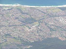 Aerial photo overlooking Corrimal and Tarrawanna to East Corrimal | |||||||||||||||
|
East Corrimal | |||||||||||||||
| Coordinates | 34°22′35″S 150°54′39″E / 34.37639°S 150.91083°ECoordinates: 34°22′35″S 150°54′39″E / 34.37639°S 150.91083°E | ||||||||||||||
| Population | 3,405 (2016 census)[1] | ||||||||||||||
| Postcode(s) | 2518 | ||||||||||||||
| LGA(s) | City of Wollongong | ||||||||||||||
| State electorate(s) | Keira | ||||||||||||||
| Federal Division(s) | Cunningham | ||||||||||||||
| |||||||||||||||
East Corrimal is a northern seaside suburb of Wollongong, New South Wales, Australia. Predominantly residential, the suburb includes Corrimal High School and Corrimal East Public School, as well as Corrimal Beach and tourist park at the eastern end. A park was opened in 1959 to the west of the high school and north of the primary school, named Phil Adams Park, which features tall trees, paths and several seats.
The South Coast railway line forms the western boundary of East Corrimal and separates it from its sister suburb Corrimal. It is served by Corrimal railway station.
The suburb takes its name from a point on the nearby Illawarra escarpment which was known as Mount Corrimal (named after the Aboriginal Dreamtime warrior Kurimul) and now called Broker's Nose.[2]
Schools
Corrimal High School is located in Corrimal. Corrimal East Public School is a local public primary school, established in 1952.[3]
See also
References
- ↑ Australian Bureau of Statistics (27 June 2017). "East Corrimal (State Suburb)". 2016 Census QuickStats. Retrieved 16 July 2017.

- ↑ "Place names of the Wollongong region". Wollongong City Council. Archived from the original on 2008-12-30. Retrieved 2009-03-07.
- ↑ "orrimal East Public School". Retrieved 1 July 2010.