Shell Cove, New South Wales
| Shell Cove Shellharbour, New South Wales | |||||||||||||||
|---|---|---|---|---|---|---|---|---|---|---|---|---|---|---|---|
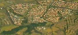 Aerial view from the east | |||||||||||||||
|
Shell Cove | |||||||||||||||
| Coordinates | 34°35.4′S 150°51.7′E / 34.5900°S 150.8617°ECoordinates: 34°35.4′S 150°51.7′E / 34.5900°S 150.8617°E | ||||||||||||||
| Population | 5,624 (2016 census)[1] | ||||||||||||||
| Postcode(s) | 2529 | ||||||||||||||
| LGA(s) | City of Shellharbour | ||||||||||||||
| State electorate(s) | Shellharbour | ||||||||||||||
| Federal Division(s) | Gilmore | ||||||||||||||
| |||||||||||||||
Shell Cove is a seaside suburb in the Shellharbour area located just south of Wollongong, New South Wales, Australia. Shell Cove adjoins Bass Point and Killalea State Park and includes a variety of facilities and amenities such as: parks and bush reserves, The Links Golf Course, Shell Cove Primary School & pre-schools, Family Health Medical Centre and a general store.
Heritage listings
Shell Cove has a number of heritage-listed sites, including:
- Boollwarroo Parade: Bass Point Reserve[2]
References
- ↑ Australian Bureau of Statistics (27 June 2017). "Shell Cove (State Suburb)". 2016 Census QuickStats. Retrieved 14 July 2017.

- ↑ "Bass Point Reserve, New South Wales State Heritage Register (NSW SHR) Number H01896". New South Wales State Heritage Register. Office of Environment and Heritage. Retrieved 18 May 2018.
This article is issued from
Wikipedia.
The text is licensed under Creative Commons - Attribution - Sharealike.
Additional terms may apply for the media files.