Keiraville, New South Wales
| Keiraville Wollongong, New South Wales | |||||||||||||||
|---|---|---|---|---|---|---|---|---|---|---|---|---|---|---|---|
 Wollongong Botanic Garden | |||||||||||||||
|
Keiraville | |||||||||||||||
| Coordinates | 34°23′S 150°52′E / 34.383°S 150.867°ECoordinates: 34°23′S 150°52′E / 34.383°S 150.867°E | ||||||||||||||
| Population | 3,070 (2016 census)[1] | ||||||||||||||
| • Density | 930/km2 (2,410/sq mi) | ||||||||||||||
| Postcode(s) | 2500 | ||||||||||||||
| Area | 3.3 km2 (1.3 sq mi) | ||||||||||||||
| Location | 3 km (2 mi) from Wollongong | ||||||||||||||
| LGA(s) | City of Wollongong | ||||||||||||||
| State electorate(s) | Keira | ||||||||||||||
| Federal Division(s) | Cunningham | ||||||||||||||
| |||||||||||||||
Keiraville is an inner suburb of the city of Wollongong, New South Wales, Australia in the Illawarra region. It is situated in the foothills of Mount Keira, approximately three kilometres northwest of Wollongong.
Description
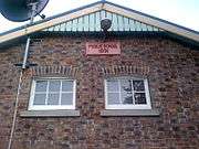
Original Keiraville Public School building
Keiraville has a public school (the Keiraville Public School[2]), post office and several shops located on Gipps Road.
Keiraville (and its neighbour Gwynneville) is known as a university town, home to the main campus of the University of Wollongong.
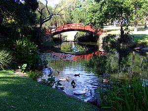
Another major landmark, Wollongong Botanic Garden, is situated between Northfields Avenue and Murphys Avenue, and includes the Wollongong Conservatorium of Music.
Heritage listings
Keiraville has a number of heritage-listed sites, including:
- Murphys Avenue: Gleniffer Brae[3]
See also
References
- ↑ Australian Bureau of Statistics (27 June 2017). "Keiraville (State Suburb)". 2016 Census QuickStats. Retrieved 15 July 2017.

- ↑
- ↑ "Gleniffer Brae, New South Wales State Heritage Register (NSW SHR) Number H00557". New South Wales State Heritage Register. Office of Environment and Heritage. Retrieved 18 May 2018.
External links
This article is issued from
Wikipedia.
The text is licensed under Creative Commons - Attribution - Sharealike.
Additional terms may apply for the media files.