Coledale railway station
Coledale | |||||||||||||
|---|---|---|---|---|---|---|---|---|---|---|---|---|---|
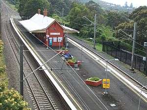 Northbound view from Cater Street in October 2011 | |||||||||||||
| Location |
Cater Street, Coledale Australia | ||||||||||||
| Coordinates | 34°17′22″S 150°56′36″E / 34.289369°S 150.943335°ECoordinates: 34°17′22″S 150°56′36″E / 34.289369°S 150.943335°E | ||||||||||||
| Elevation | 130 feet (40 m) | ||||||||||||
| Owned by | RailCorp | ||||||||||||
| Operated by | NSW TrainLink | ||||||||||||
| Line(s) | South Coast railway line | ||||||||||||
| Distance | 66.23 kilometres from Central | ||||||||||||
| Platforms | 2 (1 island) | ||||||||||||
| Tracks | 2 | ||||||||||||
| Construction | |||||||||||||
| Structure type | Ground | ||||||||||||
| Other information | |||||||||||||
| Station code | COL | ||||||||||||
| Website | Transport for NSW | ||||||||||||
| History | |||||||||||||
| Opened | July 1902 | ||||||||||||
| Electrified | Yes | ||||||||||||
| Traffic | |||||||||||||
| Passengers (2013) | 40 (daily)[1] (Sydney Trains, NSW TrainLink) | ||||||||||||
| Rank | 269 | ||||||||||||
| |||||||||||||
Coledale railway station is located on the South Coast railway line in New South Wales, Australia. It serves the seaside village of Coledale opening in July 1902.[2] The station building was built in 1915 when the line was duplicated.[3]
Platforms & services
Coledale has one island platform with two faces. It is serviced by NSW TrainLink South Coast line services travelling between Waterfall and Port Kembla. Some peak hour and late night services operate to Sydney Central, Bondi Junction and Kiama.[4]
| Platform | Line | Stopping pattern | Notes |
| 1 | services to Waterfall peak hour & late night services to Sydney Central & Bondi Junction |
[4] | |
|---|---|---|---|
| 2 | services to Thirroul & Port Kembla peak hour & late night services to Kiama |
[4] |
References
- ↑ Bureau of Transport Statistics. "Train Statistics 2014" (PDF). Transport NSW. Retrieved 15 July 2018.
- ↑ Coledale Station NSWrail.net
- ↑ Coledale Railway Station Group NSW Environment & Heritage
- 1 2 3 "South Coast line timetable". Transport for NSW.
External links
![]()
- Coledale station details Transport for New South Wales
This article is issued from
Wikipedia.
The text is licensed under Creative Commons - Attribution - Sharealike.
Additional terms may apply for the media files.