Pickering—Scarborough East (provincial electoral district)
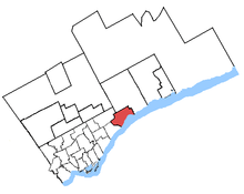 Pickering—Scarborough East in relation to other Greater Toronto ridings | |
| Defunct provincial electoral district | |
| Legislature | Legislative Assembly of Ontario |
| District created | 2003 |
| District abolished | 2018 |
| First contested | 2007 |
| Last contested | 2014 |
| Demographics | |
| Population (2006) | 106,602 |
| Electors (2011) | 76,709 |
| Area (km²) | 52 |
| Census divisions | Durham, Toronto |
| Census subdivisions | Pickering, Scarborough |
.png)
Pickering—Scarborough East was a provincial electoral district in Ontario, Canada, that was represented in the Legislative Assembly of Ontario between 2007 and 2018.
The district was created in 2003 from 44.1% of Pickering—Ajax—Uxbridge, 39.7% of Scarborough East, and 0.1% of Scarborough—Rouge River ridings.
The district consisted of the southwest part of the city of Pickering and the southeast part of the Scarborough district of Toronto.
Specifically, it consisted of the part of the City of Pickering lying south and west of a line drawn from the western city limit east along Finch Avenue, south along Valley Farm Road, northeast along Highway 401 and south along Brock Road to the southern city limit; and the part of the City of Toronto lying south and east of a line drawn from the eastern city limit west along Finch Avenue East, south along Meadowvale Road, west along Sheppard Avenue East, south along Morningside Avenue and southeast along Highland Creek to Lake Ontario.
In 2018, the district was dissolved into Pickering—Uxbridge and Scarborough—Rouge Park.
Demographics
(According to the Canada 2006 Census)
Ethnic groups: 61.3% White, 13.5% South Asian, 10.4% Black, 4.1% Filipino, 3.2% Chinese
Languages: 74.6% English, 1.3% French, 23.9% Other
Average income: $31 920
Members of Provincial Parliament
| Pickering—Scarborough East | ||||
|---|---|---|---|---|
| Assembly | Years | Member | Party | |
| Riding created from Pickering—Ajax—Uxbridge, Scarborough East and Scarborough—Rouge River | ||||
| 39th | 2007–2011 | Wayne Arthurs | Liberal | |
| 40th | 2011–2014 | Tracy MacCharles | Liberal | |
| 41st | 2014–2018 | |||
| Riding merged into Scarborough—Rouge Park and Pickering—Uxbridge | ||||
Election results
| Ontario general election, 2014 | ||||||||
|---|---|---|---|---|---|---|---|---|
| Party | Candidate | Votes | % | ±% | ||||
| Liberal | Tracy MacCharles | 23,128 | 51.76 | +5.10 | ||||
| Progressive Conservative | Kevin Gaudet | 12,623 | 28.25 | -5.16 | ||||
| New Democratic | Eileen Higdon | 6,599 | 14.77 | -1.70 | ||||
| Green | Anthony Navarro | 1,548 | 3.46 | +0.65 | ||||
| Libertarian | Scott Hoefig | 590 | 1.32 | +0.67 | ||||
| Freedom | Matt Oliver | 192 | 0.43 | |||||
| Total valid votes | 44,680 | 100.0 | ||||||
| Liberal hold | Swing | +5.13 | ||||||
| Source: Elections Ontario[1] | ||||||||
| Ontario general election, 2011 | ||||||||
|---|---|---|---|---|---|---|---|---|
| Party | Candidate | Votes | % | ±% | ||||
| Liberal | Tracy MacCharles | 18,201 | 46.66 | -1.97 | ||||
| Progressive Conservative | Kevin Gaudet | 13,033 | 33.41 | +1.70 | ||||
| New Democratic | Nerissa Carino | 6,424 | 16.47 | +5.24 | ||||
| Green | Kevin Smith | 1,096 | 2.81 | -3.52 | ||||
| Libertarian | Heath Thomas | 252 | 0.65 | -0.27 | ||||
| Total valid votes | 39,006 | 100.00 | ||||||
| Total rejected, unmarked and declined ballots | 166 | 0.42 | ||||||
| Turnout | 39,172 | 49.69 | ||||||
| Eligible voters | 78,835 | |||||||
| Liberal hold | Swing | -1.84 | ||||||
| Source: Elections Ontario[2] | ||||||||
| Ontario general election, 2007 | ||||||||
|---|---|---|---|---|---|---|---|---|
| Party | Candidate | Votes | % | |||||
| Liberal | Wayne Arthurs | 19,762 | 48.63 | |||||
| Progressive Conservative | Diana Hall | 12,884 | 31.71 | |||||
| New Democratic | Andrea Moffat | 4,563 | 11.23 | |||||
| Green | Anita Lalchan | 2,572 | 6.33 | |||||
| Libertarian | Josh Insang | 375 | 0.92 | |||||
| Independent | John Newell | 270 | 0.66 | |||||
| Family Coalition | Mitchell Andrew Persaud | 210 | 0.52 | |||||
| Total valid votes | 40,636 | 100.0 | ||||||
2007 electoral reform referendum
| Ontario electoral reform referendum, 2007 | |||
|---|---|---|---|
| Side | Votes | % | |
| First Past the Post | 24,849 | 63.5 | |
| Mixed member proportional | 14,274 | 36.5 | |
| Total valid votes | 39,123 | 100.0 | |
Sources
- ↑ "General Election Results by District, 072 Pickering—Scarborough East". Elections Ontario. 2014. Retrieved 17 June 2014.
- ↑ "Official return from the records / Rapport des registres officiels - Pickering—Scarborough East" (PDF). Elections Ontario. 2011. Retrieved 5 June 2014.