Pherzawl district
| Pherzawl district | |
|---|---|
| District of Manipur | |
| Country | India |
| State | Manipur |
| Established | 2016 |
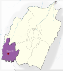
| Headquarters | Pherzawl |
| Area | |
| • Total | 2,285 km2 (882 sq mi) |
| Population | |
| • Total | 47,250[1][2] |
| Demographics | |
| • Literacy | 79% |
| Vehicle registration | MN0[3] |
| Major highways | NH-150, NH-2 |
| Coordinates | 93° 11' 16.0440 East and 24° 15' 43.0524 N |
| Website | Official website |
Pherzawl (Pron:/ˌpherˈzâwl/) is a district of Manipur state in India.
Location and politics
Pherzawl District is located in the southern part of the state of Manipur. It is bounded on the east by Churachandpur District; on the north by Tamenglong District; on the west by the Cachar District of Assam and on the South by Sinlung Hills,[4] Mizoram. Pherzawl District is located between 93° 11' 16.0440' East Longitude and 24° 15' 43.0524' North Latitude and is in the southern part of Manipur state. Pherzawl District has approximately 200 villages, according to the government's record.
The Pherzawl District came into existence on 8 December 2016 by joining 55-AC Tipaimukh (ST) and 56-AC Thanlon (ST) with its headquarters at Pherzawl. Despite the controversy surrounding the creation of seven new revenue districts in Manipur, the people of Pherzawl District welcomed the decision with celebrations[5] on December 16, 2016, when Manipur Chief Minister O.Ibobi Singh inaugurated the administrative centre at Pherzawl village.
Transport
Pherzawl is connected with the state capital Imphal via roads. A bus service to Pherzawl was flagged off by Chief Minister N Biren Singh on June 25, 2017. The state bus will ply between Imphal and Pherzawl.
Climate and geography
The district is under humid subtropical climate. The soil is moderately fertile with clay loam soil with little patches of clay and loam. The temperature ranges from a minimum of 3.4 °C (38.1 °F) to a maximum of 34.1 °C (93.4 °F). The annual rainfall ranges from 670 to 1,450 mm (26 to 57 in). The elevation of the District is 1037 meters, or 3,402 feet.
About 80% of the land area is covered by forest while the remaining 20% is utilized for cultivation. Rice, Maize and Ginger are the district's major crops. Agriculture is the main occupation of the people.
Administrative divisions
The district is divided into 4 sub-divisions:
- Pherzawl Sub-Division
- Parbung Sub-Division
- Thanlon Sub-Division
- Vangai Range Sub-Division
Literacy
The literacy rate in Pherzawl District is 79%.[6][7] 37,328 out of total 47,250 population are educated here. Among males the literacy rate is 83.5% as 19,961 males out of total 23,906 are literate while female literacy rate is 76% as 17,747 out of total 23,353 females are literate. The main language spoken is Hmar
References
- ↑ http://www.census2011.co.in/data/subdistrict/1868-tipaimukh-churachandpur-manipur.html
- ↑ http://www.census2011.co.in/data/subdistrict/1869-thanlon-churachandpur-manipur.html
- ↑ http://rtoaifmvd.com/Contact_Manipur.aspx
- ↑ https://en.m.wikipedia.org/wiki/Draft:Sinlung_Hills_Council
- ↑ https://www.youtube.com/watch?v=D-6cTHb5zgY
- ↑ https://indikosh.com/subd/283532/tipaimukh
- ↑ https://indikosh.com/dist/708851/pherzawl
External links
- Pherzawldistrict.com - People's Portal
- Official government site
- Pherzawl District Inauguration Photos
- CM inaugurates Pherzawl ADC, VIRTHLI
- CM inaugurates ADC Pherzawl building
- State Govt Liorders creation of 7 new districts