Mannar Island
| Mannar Island மன்னார் මන්නාරම | |
|---|---|
| Island | |
 Mannar Island  Mannar Island | |
| Coordinates: 9°03′0″N 79°50′0″E / 9.05000°N 79.83333°E | |
| Country | Sri Lanka |
| Province | Northern |
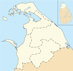
| District | Mannar |
| DS Division | Mannar |
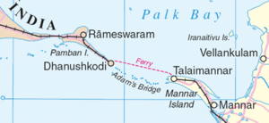
Mannar Island (Tamil: மன்னார் தீவு; Sinhalese: මන්නාරම් දූපත) formerly spelt Manar Island, is part of Mannar District, Sri Lanka. It is linked to the main island of Sri Lanka by a causeway. It has an area of about 50 square kilometres, mainly covered with vegetation and sand. Adam's Bridge (Tamil: ஆதம் பாலம் āthām pālam), is a chain of limestone shoals, between Pamban Island, also known as Rameswaram Island, off the southeastern coast of Tamil Nadu, India, and Mannar Island, off the northwestern coast of Sri Lanka. Geological evidence suggests that this bridge is a former land connection between India and Sri Lanka.
Between 1914 and 1964, there was a train and ferry link from mainland India via Dhanushkodi and Talaimannar to Colombo, but this was not resumed after the disastrous damages caused by a cyclone in 1964. The Palk Strait bridge was proposed in June 2015, to link mainland India to Mannar.
The island is dry and barren; fishing is economically important.[1]
Its main settlements are Mannar and Erukkulampiddi on its eastern coast and Pesalai on its northern coast, all connected by the A14 road which leads across the bridge to mainland Sri Lanka[2][3]
See also
References
- ↑ Britannica article.
- ↑ Google Maps (Map). Google.
|access-date=requires|url=(help) - ↑ Bing Maps (Map). Microsoft and Harris Corporation Earthstar Geographics LLC.
|access-date=requires|url=(help)