Page, Arizona
| Page, Arizona | |
|---|---|
| City | |
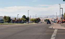 View of Lake Powell Boulevard in Page | |
| Motto(s): "The Center of Canyon Country" | |
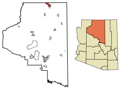 Location of Page in Coconino County, Arizona | |
 Page, Arizona Location in the United States | |
| Coordinates: 36°54′51″N 111°27′35″W / 36.91417°N 111.45972°WCoordinates: 36°54′51″N 111°27′35″W / 36.91417°N 111.45972°W | |
| Country | United States |
| State | Arizona |
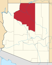
| County | Coconino |
| Government | |
| • Mayor | Bill Diak |
| Area[1] | |
| • Total | 38.34 sq mi (99.30 km2) |
| • Land | 38.19 sq mi (98.92 km2) |
| • Water | 0.15 sq mi (0.38 km2) |
| Elevation | 4,118 ft (1,255 m) |
| Population (2010)[2] | |
| • Total | 7,247 |
| • Estimate (2016)[3] | 7,599 |
| • Density | 198.96/sq mi (76.82/km2) |
| Time zone | UTC−7 (MST) |
| • Summer (DST) | UTC−7 (no DST/PDT) |
| ZIP codes | 86036, 86040 |
| Area code(s) | 928 |
| FIPS code | 04-51810 |
| Website | cityofpage.org |
Page is a city in Coconino County, Arizona, United States, near the Glen Canyon Dam and Lake Powell. As of the 2010 census, the population of the city was 7,247.[4]
History
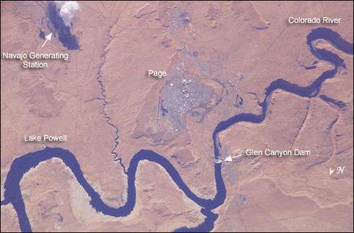
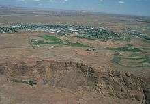
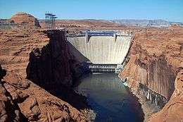
Unlike other cities in the area, Page was founded in 1957 as a housing community for workers and their families during the construction of nearby Glen Canyon Dam on the Colorado River. Its 17-square-mile (44 km2) site was obtained in a land exchange with the Navajo Nation. The city is perched atop Manson Mesa at an elevation of 4,300 feet (1,300 m) above sea level and 600 feet (180 m) above Lake Powell.
The city was originally called Government Camp, but was later named for John C. Page, Commissioner of the Bureau of Reclamation, 1936-1943.
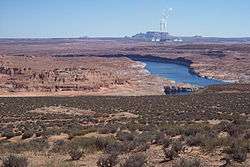
After the dam was completed in the 1960s, and was officially incorporated (March 1, 1975), the city grew steadily to today's population of over 7,000. Because of the new roads and bridge built for use during construction, it has become the gateway to the Glen Canyon National Recreation Area and Lake Powell, attracting more than 3 million visitors per year. Page is also the home of two of the largest electrical generation units in the western United States. Glen Canyon Dam has a 1,288,000-kilowatt capacity when fully online. The other power plant to the southeast is the Navajo Generating Station, a coal-fired steam plant with an output capability of 2,250,000 kilowatts.
On War Thunder update 1.81 'The Valkyries', this location is inspired but it takes place in the 60s.
Geography
Page is located at 36°54′51″N 111°27′35″W / 36.91417°N 111.45972°W (36.914296, -111.459717).[5] According to the United States Census Bureau, the city has a total area of 16.6 square miles (43 km2), of which 16.6 square miles (43 km2) is land and 0.04 square miles (0.10 km2), or 0.12%, is water.
Climate
Page has an arid climate (Köppen BWk) with hot, very dry summers and chilly winters with very little snow. It is located in the southern edge of the Great Basin Desert on the Colorado Plateau. It is very dry due to being in the rainshadow of the mountains of California and too far north to get consistent North American Monsoons.
| Climate data for Page, Arizona | |||||||||||||
|---|---|---|---|---|---|---|---|---|---|---|---|---|---|
| Month | Jan | Feb | Mar | Apr | May | Jun | Jul | Aug | Sep | Oct | Nov | Dec | Year |
| Record high °F (°C) | 64 (18) |
72 (22) |
82 (28) |
91 (33) |
102 (39) |
107 (42) |
109 (43) |
106 (41) |
100 (38) |
93 (34) |
77 (25) |
66 (19) |
109 (43) |
| Average high °F (°C) | 43.1 (6.2) |
50.3 (10.2) |
59.5 (15.3) |
68.5 (20.3) |
78.5 (25.8) |
90.2 (32.3) |
95.1 (35.1) |
92.0 (33.3) |
83.5 (28.6) |
69.7 (20.9) |
53.8 (12.1) |
43.7 (6.5) |
69.0 (20.6) |
| Average low °F (°C) | 26.3 (−3.2) |
30.4 (−0.9) |
37.0 (2.8) |
43.6 (6.4) |
52.6 (11.4) |
62.3 (16.8) |
68.3 (20.2) |
66.4 (19.1) |
58.4 (14.7) |
46.6 (8.1) |
34.7 (1.5) |
27.1 (−2.7) |
46.1 (7.8) |
| Record low °F (°C) | −11 (−24) |
6 (−14) |
18 (−8) |
25 (−4) |
31 (−1) |
44 (7) |
56 (13) |
46 (8) |
40 (4) |
24 (−4) |
16 (−9) |
1 (−17) |
−11 (−24) |
| Average precipitation inches (mm) | 0.61 (15.5) |
0.48 (12.2) |
0.65 (16.5) |
0.50 (12.7) |
0.40 (10.2) |
0.14 (3.6) |
0.58 (14.7) |
0.69 (17.5) |
0.66 (16.8) |
0.99 (25.1) |
0.56 (14.2) |
0.48 (12.2) |
6.74 (171.2) |
| Average snowfall inches (cm) | 2.1 (5.3) |
1.2 (3) |
0.2 (0.5) |
0 (0) |
0 (0) |
0 (0) |
0 (0) |
0 (0) |
0 (0) |
0 (0) |
0.5 (1.3) |
1.4 (3.6) |
5.4 (13.7) |
| Average precipitation days (≥ 0.01 in) | 4.5 | 4.0 | 5.2 | 3.5 | 3.2 | 1.7 | 4.6 | 5.2 | 4.5 | 4.3 | 3.2 | 3.9 | 47.8 |
| Average snowy days (≥ 0.1 in) | 0.9 | 0.6 | 0.3 | 0 | 0 | 0 | 0 | 0 | 0 | 0 | 0.2 | 0.6 | 2.6 |
| Source: NOAA[6] | |||||||||||||
Demographics
| Historical population | |||
|---|---|---|---|
| Census | Pop. | %± | |
| 1960 | 2,960 | — | |
| 1970 | 1,439 | −51.4% | |
| 1980 | 4,907 | 241.0% | |
| 1990 | 6,598 | 34.5% | |
| 2000 | 6,809 | 3.2% | |
| 2010 | 7,247 | 6.4% | |
| Est. 2016 | 7,599 | [3] | 4.9% |
| U.S. Decennial Census[7] | |||
As of the census[8] of 2010, there were 7,247 people, 2,518 households, and 1,822 families residing in the city. The population density was 426.3 inhabitants per square mile (164.6/km2). There were 2,787 housing units at an average density of 163.9 per square mile (63.3/km2). The racial makeup of the city was 57.6% White, 0.3% Black or African American, 34.0% Native American, 0.9% Asian, 0.0% (two people) Pacific Islander, 2.1% from other races, and 5.0% from two or more races. 7.3% of the population were Hispanic or Latino of any race.
There were 2,518 households out of which 40.6% had children under the age of 18 living with them, 51.9% were married couples living together, 12.9% had a female householder with no husband present, and 27.6% were non-families. 20.7% of all households were made up of individuals and 7.7% had someone living alone who was 65 years of age or older. The average household size was 2.87 and the average family size was 3.32.
In the city, the age distribution of the population shows 29.6% under the age of 18, 10.4% from 18 to 24, 26.2% from 25 to 44, 26.0% from 45 to 64, and 9% who were 65 years of age or older. The median age was 32.5 years. For every 100 females, there were 101.5 males. For every 100 females age 18 and over, there were 100.9 males.
As of the 2015 American Community Survey[9] The median income for a household in the city was $57,161, and the median income for a family was $64,135. Males had a median full-time income of $47,779 versus $37,656 for females. The per capita income for the city was $24,338. About 14.1% of families and 14.4% of the population were below the poverty line, including 18.7% of those under age 18 and 1.5% of those age 65 or over.
Education
Page is served by the Page Unified School District. Two public elementary schools, Desert View Elementary School and Lake View Elementary School, are located in the city and serve the city. Page Middle School and Page High School are also located in the city.
Economy
Top employers
According to Page's 2014 Comprehensive Annual Financial Report,[10] the top employers in the city are:
| # | Employer | # of Employees |
|---|---|---|
| 1 | Aramark | 700 |
| 2 | Navajo Generating Station | 498 |
| 3 | Page Unified School District | 436 |
| 4 | Walmart | 210 |
| 5 | City of Page | 180 |
| 6 | Gary Yamamoto Custom Baits | 165 |
| 7 | Page Hospital | 115 |
| 8 | Safeway | 100 |
| 9 | Courtyard by Marriott | 90 |
| 10 | Page Steel | 84 |
| 11 | Canyonlands Community Health | 54 |
Transportation
Page is located on U.S. Route 89. Arizona State Route 98 heads east into the Navajo reservation. Page Shuttle provides 24/7, non-stop, door to door shuttle service between Page and any city in Arizona. Public transportation is provided by Helping Hands Agency, a local nonprofit, under the name Helping Hands Express.[11] Salt Lake Express provides a shuttle between Page and St. George, Utah.[12]
Page Municipal Airport serves Page with scheduled, charter, and general aviation.
Media
The Lake Powell Chronicle is the weekly newspaper in Page.
Films and television
Several films and television series have been shot in the Page area including:
- The Greatest Story Ever Told (1965)
- Planet of the Apes (1968)
- The Outlaw Josey Wales (1976)
- Exorcist II: The Heretic (1977)
- Superman III (1983)
- Thunder Warrior (1983)
- Hands of Steel (1986), shot in 1985 by Sergio Martino
- Highway to Hell (1990)
- Motorama (1991)
- Beastmaster 2: Through the Portal of Time (1991)
- Maverick (1994)
- Broken Arrow (1996)
- Evolution (2000)
- Planet of the Apes (2000)
- The Flintstones in Viva Rock Vegas (2000)
- Eight Legged Freaks (2002)
- Hulk (2003)
- The Amazing Race 8 (2005)
- Into the Wild (2007)
- Doctor Who: Season 6, episodes 1, 2 and 13 (2012)
- John Carter (2012)
- The Fireball Run: Season 7, episodes 5 and 6 (2014)
Literature
Page appears as the main town in the 4th of the Sheriff Wyler Scott series novels title "Broken Canyon"
Page (and the surrounding areas of Glen Canyon) also appear in Edward Abbey's The Monkey Wrench Gang.
Notable people
- Mary Antonia Wood, artist
References
- ↑ "2016 U.S. Gazetteer Files". United States Census Bureau. Retrieved Jul 18, 2017.
- ↑ "American FactFinder". United States Census Bureau. Retrieved 2014-08-23.
- 1 2 "Population and Housing Unit Estimates". Retrieved June 9, 2017.
- ↑ "Profile of General Population and Housing Characteristics: 2010 Demographic Profile Data (DP-1): Page city, Arizona". U.S. Census Bureau, American Factfinder. Retrieved December 7, 2011.
- ↑ "US Gazetteer files: 2010, 2000, and 1990". United States Census Bureau. 2011-02-12. Retrieved 2011-04-23.
- ↑ "Climatography of the United States No. 20 (1971–2000)" (PDF). National Oceanic and Atmospheric Administration. 2004. Retrieved 2010-05-31.
- ↑ "Census of Population and Housing". Census.gov. Retrieved June 4, 2016.
- ↑ "American FactFinder". United States Census Bureau. Retrieved 2008-01-31.
- ↑ Bureau, U.S. Census. "American FactFinder - Results". factfinder.census.gov. Retrieved 2017-06-01.
- ↑ City of Page CAFR
- ↑ Helping Hands Express
- ↑ Salt Lake Express
External links
| Wikimedia Commons has media related to Page, Arizona. |
| Wikivoyage has a travel guide for Page, Arizona. |