Allan Lake Landing, Arizona
| Allan Lake Landing, Arizona | |
|---|---|
| Unpopulated Area | |
 Allan Lake Landing, Arizona Location within the state of Arizona  Allan Lake Landing, Arizona Allan Lake Landing, Arizona (the US) | |
| Coordinates: 34°49′31″N 111°26′12″W / 34.82528°N 111.43667°WCoordinates: 34°49′31″N 111°26′12″W / 34.82528°N 111.43667°W | |
| Country | United States |
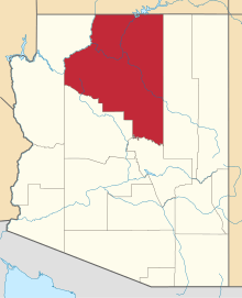
| State | Arizona |
| County | Coconino |
| Elevation[1] | 7,464 ft (2,275 m) |
| Time zone | UTC-7 (Mountain (MST)) |
| • Summer (DST) | UTC-7 (MST) |
| Area code(s) | 928 |
| GNIS feature ID | 25592 |
Allan Lake Landing is a unpopulated place situated in Coconino County, Arizona.[2] It has an estimated elevation of 7,460 feet (2,270 m) above sea level.[1] The area was used as a turnaround for a logging railroad in the past which removed many of the trees to the east of Lake Mary Road. The unusual shape of the lake is due to a habitat improvement project by the Arizona Game and Fish Department in 1986. The project ultimately failed and restoration efforts are currently underway to improve the site.
References
- 1 2 "Feature Detail Report for: Allan Lake Landing". Geographic Names Information System. United States Geological Survey.
- ↑ "Allan Lake Landing (in Coconino County, AZ) Populated Place Profile". AZ Hometown Locator. Retrieved November 5, 2016.
This article is issued from
Wikipedia.
The text is licensed under Creative Commons - Attribution - Sharealike.
Additional terms may apply for the media files.