Tin House, Arizona
| Tin House, Arizona | |
|---|---|
| Populated place | |
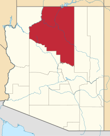
 Tin House Location within the state of Arizona  Tin House Tin House (the US) | |
| Coordinates: 35°41′52″N 112°32′46″W / 35.69778°N 112.54611°WCoordinates: 35°41′52″N 112°32′46″W / 35.69778°N 112.54611°W | |
| Country | United States |
| State | Arizona |
| County | Coconino |
| Elevation[1] | 5,512 ft (1,680 m) |
| Time zone | UTC-7 (Mountain (MST)) |
| • Summer (DST) | UTC-7 (MST) |
| Area code(s) | 928 |
| FIPS code | 04-73895 |
| GNIS feature ID | 25254 |
Tin House is a populated place in Coconino County, Arizona, in the United States.[2]
References
This article is issued from
Wikipedia.
The text is licensed under Creative Commons - Attribution - Sharealike.
Additional terms may apply for the media files.