Cameron, Arizona
| Cameron, Arizona | |
|---|---|
| CDP | |
 | |
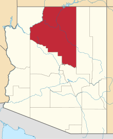
 Location in Coconino County and the state of Arizona | |
 Cameron, Arizona Location in the United States  Cameron, Arizona Cameron, Arizona (the US) | |
| Coordinates: 35°52′30″N 111°24′48″W / 35.87500°N 111.41333°WCoordinates: 35°52′30″N 111°24′48″W / 35.87500°N 111.41333°W | |
| Country | United States |
| State | Arizona |
| County | Coconino |
| Area[1] | |
| • Total | 18.74 sq mi (48.54 km2) |
| • Land | 18.72 sq mi (48.50 km2) |
| • Water | 0.02 sq mi (0.04 km2) |
| Elevation | 4,202 ft (1,281 m) |
| Population (2010) | |
| • Total | 885 |
| • Estimate (2016)[2] | N/A |
| Time zone | UTC-7 (MST) |
| • Summer (DST) | UTC-6 (MDT) |
| ZIP codes | 86016, 86020 |
| Area code | 928 |
| FIPS code | 04-09340 |
| GNIS feature ID | 0002396 |
Cameron (Navajo: Naʼníʼá Hasání) is a census-designated place (CDP) in Coconino County, Arizona, United States. The population was 885 at the 2010 census.[3] Most of the town's economy is tourist food and craft stalls, restaurants, and other services for north-south traffic from Flagstaff and Page. There is a ranger station supplying information and hiking permits for the Navajo Nation as well as a small selection of books for sale. There is also a large craft store run by the Nation itself; most vendors in the area operate from small private stalls.
Geography
Cameron is located at 35°51′19″N 111°25′17″W / 35.85528°N 111.42139°W (35.855410, -111.421465)[4] on the Navajo Nation. Elevation is 4,216 feet (1,285 m) above sea level. It is immediately south of the Little Colorado River, just above the beginning of the Little Colorado River Gorge and the stream's descent into the Grand Canyon. Cameron lies at the intersection of US 89 and State Route 64, not far from the Desert View entrance to Grand Canyon National Park.
According to the United States Census Bureau, the CDP has a total area of 18.7 square miles (48.5 km2), of which 0.02 square miles (0.04 km2) is water.[5]
Demographics
| Historical population | |||
|---|---|---|---|
| Census | Pop. | %± | |
| U.S. Decennial Census[6] | |||
| Languages (2000) [7] | Percent |
|---|---|
| Spoke Navajo at home | 69.49% |
| Spoke English at home | 30.51% |
As of the census[8] of 2000, there were 978 people, 236 households, and 194 families residing in the CDP. The population density was 53.0 people per square mile (20.5/km²). There were 317 housing units at an average density of 17.2/sq mi (6.6/km²). The racial makeup of the CDP was 94.68% Native American, 1.74% White, 0.10% Black or African American, 0.10% Asian, 0.82% from other races, and 2.56% from two or more races. 4.09% of the population were Hispanic or Latino of any race.
There were 236 households out of which 44.5% had children under the age of 18 living with them, 47.9% were married couples living together, 28.4% had a female householder with no husband present, and 17.4% were non-families. 15.7% of all households were made up of individuals and 4.2% had someone living alone who was 65 years of age or older. The average household size was 4.14 and the average family size was 4.61.
In the CDP, the age distribution of the population shows 41.2% under the age of 18, 10.9% from 18 to 24, 27.5% from 25 to 44, 13.7% from 45 to 64, and 6.6% who were 65 years of age or older. The median age was 24 years. For every 100 females, there were 105.0 males. For every 100 females age 18 and over, there were 91.7 males.
The median income for a household in the CDP was $24,773, and the median income for a family was $21,420. Males had a median income of $21,786 versus $12,614 for females. The per capita income for the CDP was $5,970. About 38.0% of families and 36.5% of the population were below the poverty line, including 42.0% of those under age 18 and 52.8% of those age 65 or over.
Education
The area is served by the Tuba City Unified School District. The community has one elementary school called Dzil Libei Elementary School, which is a K-6 grade school serving the community. There is also a local preschool run by the Navajo Nation.
Tuba City High School and Tuba City Elementary School serve Cameron.
References
![]()
- ↑ "2016 U.S. Gazetteer Files". United States Census Bureau. Retrieved Jul 18, 2017.
- ↑ "Population and Housing Unit Estimates". Retrieved June 9, 2017.
- ↑ "Profile of General Population and Housing Characteristics: 2010 Demographic Profile Data (DP-1): Cameron CDP, Arizona". U.S. Census Bureau, American Factfinder. Archived from the original on September 11, 2013. Retrieved December 8, 2011.
- ↑ "US Gazetteer files: 2010, 2000, and 1990". United States Census Bureau. 2011-02-12. Retrieved 2011-04-23.
- ↑ "Geographic Identifiers: 2010 Demographic Profile Data (G001): Cameron CDP, Arizona". U.S. Census Bureau, American Factfinder. Archived from the original on September 11, 2013. Retrieved December 8, 2011.
- ↑ "Census of Population and Housing". Census.gov. Retrieved June 4, 2016.
- ↑ https://apps.mla.org/map_data_results&state_id=4&place_id=9340&cty_id=
- ↑ "American FactFinder". United States Census Bureau. Archived from the original on 2013-09-11. Retrieved 2008-01-31.