Horse Mesa Dam
| Horse Mesa Dam | |
|---|---|
 | |
| Country | United States |
| Location | Tonto National Forest, Maricopa County, Arizona |
| Coordinates | 33°35′27″N 111°20′38″W / 33.59083°N 111.34389°WCoordinates: 33°35′27″N 111°20′38″W / 33.59083°N 111.34389°W |
| Construction began | 1924 |
| Opening date | 1927 |
| Owner(s) | U.S. Bureau of Reclamation |
| Dam and spillways | |
| Type of dam | Concrete thin arch |
| Impounds | Salt River |
| Height | 305 ft (93 m) |
| Length | 660 ft (200 m) |
| Width (crest) | 8 ft (2.4 m) |
| Width (base) | 57 ft (17 m) |
| Dam volume | 162,000 cu yd (124,000 m3) |
| Spillways | Gated concrete tunnel and over-the-crest |
| Spillway capacity | 150,000 cu ft/s (4,200 m3/s) |
| Reservoir | |
| Creates | Apache Lake |
| Total capacity | 245,138 acre⋅ft (0.302373 km3) |
| Catchment area | 5,842 sq mi (15,130 km2) |
| Surface area | 2,656 acres (1,075 ha) |
| Normal elevation | 1,919 ft (585 m) |
| Power Station | |
| Turbines | 3x 112/3MW units, 1x 97MW pumped-storage unit |
| Installed capacity | 129 MW |
The Horse Mesa Dam is a concrete thin arch dam located in the Superstition Mountains, northeast of Phoenix in Maricopa County, Arizona.
The dam is 660 feet (200 m) long, 300 feet (91 m) high and was built between 1924-27. The dam includes three conventional hydroelectric generating units totaling 32 megawatts (MW) and a pumped-storage unit with a capacity of 97 MW.
The dam and associated infrastructure were listed on the National Register of Historic Places in 2017.
Reservoir
The dam forms Apache Lake as it impounds the Salt River. The dam and reservoir are located downstream from the Theodore Roosevelt Dam, and upstream from the Mormon Flat Dam.
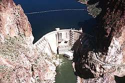
Downstream view of Horse Mesa Dam.
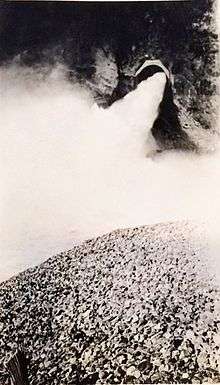
Water flowing out of a spillway at Horse Mesa, circa 1940
Salt River below the dam.
External links
- SRP Horse Mesa Dam
- Historic American Engineering Record (HAER) No. AZ-15, "Horse Mesa Dam, Salt River, 65 miles East of Phoenix, Phoenix vicinity, Maricopa County, AZ"
| Wikimedia Commons has media related to Horse Mesa Dam. |
This article is issued from
Wikipedia.
The text is licensed under Creative Commons - Attribution - Sharealike.
Additional terms may apply for the media files.