New River, Arizona
| New River, Arizona | |
|---|---|
| CDP | |
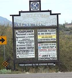 Welcome to New River | |
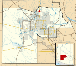 Location in Maricopa County and the state of Arizona | |
 New River, Arizona Location in the United States | |
| Coordinates: 33°52′9″N 112°5′9″W / 33.86917°N 112.08583°WCoordinates: 33°52′9″N 112°5′9″W / 33.86917°N 112.08583°W | |
| Country | United States |
| State | Arizona |
| County | Maricopa |
| Area[1] | |
| • Total | 56.10 sq mi (145.29 km2) |
| • Land | 56.09 sq mi (145.26 km2) |
| • Water | 0.01 sq mi (0.03 km2) |
| Elevation | 2,014 ft (614 m) |
| Population (2010) | |
| • Total | 14,952 |
| • Estimate (2016)[2] | N/A |
| Time zone | UTC-7 (MST (no DST)) |
| ZIP codes | 85027, 85087 |
| Area code(s) | 623, 480 |
| FIPS code | 04-49360 |
| GNIS feature ID | 0008605 |
New River is an unincorporated community and a census-designated place (CDP) in Maricopa County, Arizona, United States. The population was 14,952 at the 2010 census.[3]
History
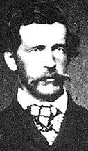
New River is named after the seasonal wash of the same name, part of the Agua Fria River system which drains into the Salt River. It was founded by Lord Darrell Duppa in 1868 as a stagecoach stop. For many years it was the terminus of the old Black Canyon Highway (now Interstate 17). The pavement ended in New River and continued as a dirt road to the city of Prescott.[4]
Geography
New River is located at 33°52′9″N 112°5′9″W / 33.86917°N 112.08583°W (33.869149, −112.085759).[5] It is bordered by the Tonto National Forest to the north, Cave Creek to the east, Phoenix to the south, and Anthem to the west. The CDP includes the area known as Desert Hills.
According to the United States Census Bureau, the CDP has a total area of 70.8 square miles (183 km2), of which, 70.8 square miles (183 km2) of it is land and 0.01% is water. It includes both Daisy Mountain and Gavilan Peak.
Government
New River is served by Deer Valley Unified School District.
Up to 1,500 New River residents rely on water hauled from fire hydrants located in Phoenix.[6]
Demographics
| Historical population | |||
|---|---|---|---|
| Census | Pop. | %± | |
| 2000 | 10,740 | — | |
| 2010 | 14,952 | 39.2% | |
| U.S. Decennial Census[7] | |||
As of the census of 2000, there were 10,740 people, 3,921 households, and 3,066 families residing in the CDP. The population density was 151.6 people per square mile (58.5/km²). There were 4,514 housing units at an average density of 63.7/sq mi (24.6/km²). The racial makeup of the CDP was 95.87% White, 0.42% Black or African American, 0.60% Native American, 0.46% Asian, 0.05% Pacific Islander, 1.25% from other races, and 1.37% from two or more races. 4.85% of the population were Hispanic or Latino of any race.
There were 3,921 households out of which 35.3% had children under the age of 18 living with them, 68.9% were married couples living together, 5.6% had a female householder with no husband present, and 21.8% were non-families. 15.3% of all households were made up of individuals and 2.9% had someone living alone who was 65 years of age or older. The average household size was 2.73 and the average family size was 3.04.
In the CDP, the population was spread out with 26.0% under the age of 18, 4.8% from 18 to 24, 33.2% from 25 to 44, 28.5% from 45 to 64, and 7.5% who were 65 years of age or older. The median age was 38 years. For every 100 females, there were 103.9 males. For every 100 females age 18 and over, there were 102.4 males.
The median income for a household in the CDP was $62,307, and the median income for a family was $68,604. Males had a median income of $46,361 versus $31,610 for females. The per capita income for the CDP was $25,932. About 3.6% of families and 5.7% of the population were below the poverty line, including 5.5% of those under age 18 and 3.1% of those age 65 or over.
According to a 2015 estimate, median incomes for households was $74,920.[8]
Local attractions
- Cave Creek Regional Park
- Lake Pleasant Regional Park
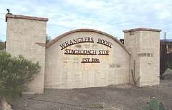
- Wranglers Roost Stagecoach Stop (Established 1890)
- Spur Cross Ranch
- Daisy Mountain Preserve
- Road Runner Restaurant & Saloon
- New River Park
- Shangri La Ranch – Family Nudist Resort
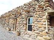
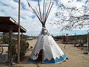
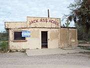
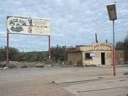
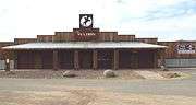
Historic structures in New River
Pictured are some of the few remaining historic structures of New River.[9][10]


See also
References
- ↑ "2016 U.S. Gazetteer Files". United States Census Bureau. Retrieved July 18, 2017.
- ↑ "Population and Housing Unit Estimates". Retrieved June 9, 2017.
- ↑ "Census 2010: Arizona - USATODAY.com". usatoday.com. Retrieved April 22, 2018.
- ↑ "New River, Arizona History and Trivia". www.hometownusa.com. Retrieved April 22, 2018.
- ↑ "US Gazetteer files: 2010, 2000, and 1990". United States Census Bureau. February 12, 2011. Retrieved April 23, 2011.
- ↑ "Phoenix Extends Deadline For Water Hauling To New River And Desert Hills". KJZZ. December 15, 2017. Retrieved April 22, 2018.
- ↑ "U.S. Decennial Census". Census.gov. Retrieved May 10, 2014.
- ↑ Bureau, U.S. Census. "American FactFinder - Community Facts". factfinder.census.gov. Retrieved April 22, 2018.
- ↑ "Wranglers Roost". wranglersroostresort.com. Retrieved April 22, 2018.
- ↑ www.nerdmecca.com. "Jack Ass Acres, Arizona - Ghost Towns of Arizona and Surrounding States". www.ghosttownaz.info. Retrieved April 22, 2018.
