| [1] |
Name on the Register |
Image |
Date listed[2] |
Location |
City or town |
Description |
|---|
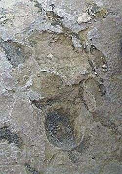
| 1 |
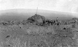
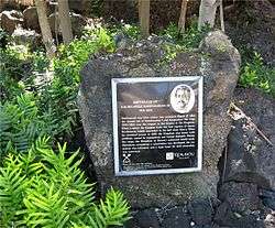
1790 Footprints |
|
August 7, 1974
(#74000351) |
9.1 miles south of park headquarters on Hawaii Route 11, then along a foot trail to the southeast for 1 mile
19°23′00″N 155°20′07″W / 19.383333°N 155.335278°W / 19.383333; -155.335278 (1790 Footprints) |
Hawaii Volcanoes National Park |
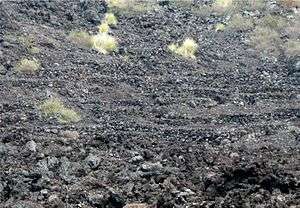
Footprints left in solidified ash from Kilauea eruption |
| 2 |
Ahole Holua Complex |
|
November 26, 1973
(#73000655) |
South of Milolii on Ahole Bay
19°08′27″N 155°54′58″W / 19.140833°N 155.916111°W / 19.140833; -155.916111 (Ahole Holua Complex) |
Milolii |
|
| 3 |
Ahu A Umi Heiau |
|
August 13, 1974
(#74000343) |
Address Restricted
|
North Kona |
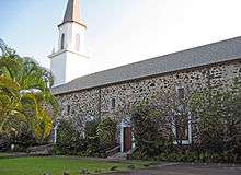
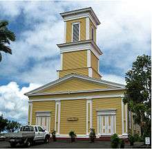
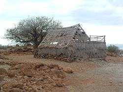
Royal complex on high remote plateau |
| 4 |
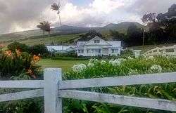
Ainahou Ranch |
|
February 8, 1995
(#94001619) |
Off Chain of Craters Road in Hawaii Volcanoes National Park
19°20′37″N 155°13′44″W / 19.343611°N 155.228889°W / 19.343611; -155.228889 (Ainahou Ranch) |
Hawaii Volcanoes National Park |
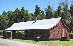
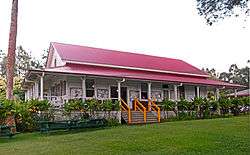
Built by Shipman family as refuge from World War II, used to raise endangered Hawaiian goose |
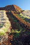
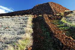
| 5 |
Ainapo Trail |
|
August 30, 1974
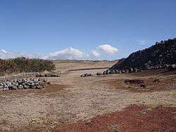
(#74000290) |
Hawaii Volcanoes National Park
19°27′39″N 155°34′39″W / 19.460833°N 155.5775°W / 19.460833; -155.5775 (Ainapo Trail) |
Mauna Loa |
Ancient trail to the Mokuaweoweo summit |
| 6 |
Ala Loa |
|
June 5, 1987
(#87001127) |
Off Hawaii Route 19 from Kiholo bay to Kalahuipaua'a
19°53′49″N 155°54′02″W / 19.896944°N 155.900556°W / 19.896944; -155.900556 (Ala Loa) |
South Kohala |
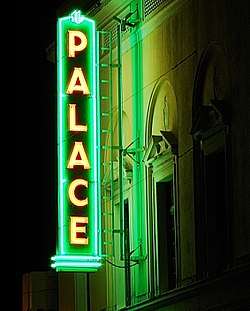
Part of Ala Kahakai National Historic Trail |
| 7 |
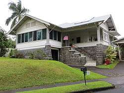
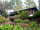
Anna Ranch |
|
April 28, 2008
(#06001120) |
65-1480 Kawaihae Rd.
20°01′23″N 155°45′59″W / 20.022942°N 155.766492°W / 20.022942; -155.766492 (Anna Ranch) |
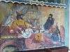
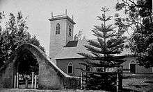
Kamuela |
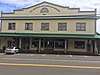
|
| 8 |
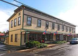
Bank of Hawai'i, Ltd. |
|
April 30, 2018
(#100002360) |
45-3568 Mamane St.
20°04′44″N 155°28′03″W / 20.0790°N 155.4675°W / 20.0790; -155.4675 (Bank of Hawai'i, Ltd.) |
Honokaʻa |
|
| 9 |
Bobcat Trail Habitation Cave (50-10-30-5004) |
|
May 15, 1986
(#86001086) |
Address Restricted
|
Pohakuloa |
|
| 10 |
Bond District |
|
March 30, 1978
(#78001016) |
Southeast of Kapaau off Hawaii Route 270
20°13′33″N 155°47′33″W / 20.225833°N 155.7925°W / 20.225833; -155.7925 (Bond District) |
Kapaau |
Homestead of Elias Bond, Kalahikiola Church, and Kohala Seminary |
| 11 |
M.S. Botelho Building and Garage |
|
March 15, 2018
(#100002214) |
45-3490 Mamane St.
20°04′42″N 155°27′57″W / 20.078272°N 155.465930°W / 20.078272; -155.465930 (M.S. Botelho Building and Garage) |
Honokaʻa |
|
| 12 |
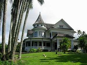
Francis H. Ii Brown House |
|
August 21, 1986
(#86001616) |
Keawaiki Bay
19°53′16″N 155°54′22″W / 19.887778°N 155.906111°W / 19.887778; -155.906111 (Francis H. Ii Brown House) |
Waimea |
Beach home for golfing champion Francis Hyde ʻĪʻī Brown (1892–1976) |
| 13 |
Chee Ying Society |
|
July 20, 1978
(#78001014) |
Hawaii Route 24
20°05′05″N 155°28′34″W / 20.084722°N 155.476111°W / 20.084722; -155.476111 (Chee Ying Society) |
Honokaʻa |
|
| 14 |
Daifukuji Soto Zen Mission |
|
April 21, 1994
(#94000382) |
Mamalahoa Highway
19°32′32″N 155°55′41″W / 19.542222°N 155.928056°W / 19.542222; -155.928056 (Daifukuji Soto Zen Mission) |
Honalo |
Buddhist Temple built 1920–1921 |
| 15 |
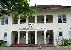
District Courthouse and Police Station |
|
September 4, 1979
(#79000752) |
141 Kalakaua St.
19°43′46″N 155°05′17″W / 19.729444°N 155.088056°W / 19.729444; -155.088056 (District Courthouse and Police Station) |
Hilo |
Built in 1932; now home of East Hawaii Cultural Center |
| 16 |
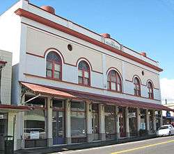
Ferreira Building |
|
October 29, 2015
(#15000756) |
45-3625 Mamane St.
20°04′45″N 155°28′10″W / 20.079274°N 155.469311°W / 20.079274; -155.469311 (Ferreira Building) |
Honokaʻa |
|
| 17 |
First Bank of Hilo, Ltd. |
|
December 28, 2017
(#100001916) |
45-3490 Mamane St., Unit G
20°04′42″N 155°27′57″W / 20.078238°N 155.465762°W / 20.078238; -155.465762 (First Bank of Hilo, Ltd.) |
Honokaʻa |
|
| 18 |
Greenwell Store |
|
May 22, 1978
(#78001017) |
Hawaii Route 11
19°30′55″N 155°55′24″W / 19.515278°N 155.923333°W / 19.515278; -155.923333 (Greenwell Store) |
Kealakekua |
Store built in 1870 now houses the Kona Historical Society Museum |
| 19 |
Thomas Guard House |
|
December 23, 2003
(#03001311) |
240 Kaʻiulani St.
19°43′40″N 155°06′03″W / 19.727778°N 155.100833°W / 19.727778; -155.100833 (Thomas Guard House) |
Hilo |
Neoclassical style home, architects Clinton Briggs Ripley and Louis Davis (architect) |
| 20 |
Hale Halawai O Holualoa |
|
June 5, 1987
(#87000794) |
76-6224 Aliʻi Dr.
19°36′36″N 155°58′41″W / 19.61°N 155.978056°W / 19.61; -155.978056 (Hale Halawai O Holualoa) |
Kailua-Kona |
Known as the "Living Stones Church" |
| 21 |
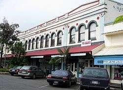
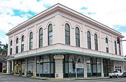
S. Hata Building |
|
August 27, 1991
(#91001087) |
318 Kamehameha Ave.
19°43′41″N 155°05′17″W / 19.728056°N 155.088056°W / 19.728056; -155.088056 (S. Hata Building) |
Hilo |
Built by Japanese American family business in 1912 |
| 22 |
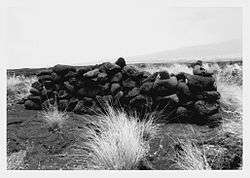
Heiau in Kukuipahu |
|
April 24, 1973
(#73000652) |
Address Restricted
|
Hawi |
|
| 23 |
Walter Irving and Jean Henderson House |
|
February 28, 2011
(#11000057) |
82 Halaulani Place
19°43′58″N 155°05′29″W / 19.732778°N 155.091389°W / 19.732778; -155.091389 (Walter Irving and Jean Henderson House) |
Hilo |
Halaulani Place, 1917-1960 MPS; Craftsman bungalow built 1925 |
| 24 |
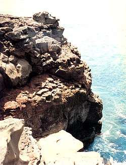
Hilina Pali Road |
|
January 14, 2015
(#09000587) |
Hawaii Volcanoes National Park
19°24′06″N 155°15′56″W / 19.4016°N 155.265629°W / 19.4016; -155.265629 (Hilina Pali Road) |
Hilo vicinity |
|
| 25 |
W.H. Hill House |
|
February 28, 2011
(#11000055) |
91 Halaulani Place
19°44′00″N 155°05′28″W / 19.733333°N 155.091111°W / 19.733333; -155.091111 (W.H. Hill House) |
Hilo |
Halaulani Place, 1917-1960 MPS; Craftsman bungalow built 1919 |
| 26 |
Hilo Masonic Lodge Hall-Bishop Trust Building |
|
April 21, 1994
(#94000383) |
Junction of Keawe and Waianuenue Streets
19°43′33″N 155°05′17″W / 19.725833°N 155.088056°W / 19.725833; -155.088056 (Hilo Masonic Lodge Hall-Bishop Trust Building) |
Hilo |
Also known as the Kaikodo (Restaurant) Building |
| 27 |
James M. Hind House |
|
February 3, 1994
(#93001557) |
Skilled Camp, House J
20°06′58″N 155°34′51″W / 20.116111°N 155.580833°W / 20.116111; -155.580833 (James M. Hind House) |
Hawi |
|
| 28 |
Holualoa 4 Archeological District (State Site No. 50-10-37-23.661) |
|
June 8, 2005
(#05000542) |
Aliʻi Drive
19°36′21″N 155°58′39″W / 19.605833°N 155.9775°W / 19.605833; -155.9775 (Holualoa 4 Archeological District (State Site No. 50-10-37-23.661)) |
Kailua-Kona |
Complex of temples and royal residences |
| 29 |
Honokaa People's Theatre |
|
October 6, 2015
(#15000684) |
45-3574 Mamane St.
20°04′45″N 155°28′04″W / 20.079233°N 155.467710°W / 20.079233; -155.467710 (Honokaa People's Theatre) |
Honokaʻa |
|
| 30 |
Honoka'a United Methodist Church |
|
December 21, 2017
(#100001413) |
45-3525 Mamane St.
20°04′43″N 155°27′59″W / 20.078486°N 155.46645°W / 20.078486; -155.46645 (Honoka'a United Methodist Church) |
Honokaʻa |
|
| 31 |
Honokohau Settlement |
|
October 15, 1966
(#66000287) |
Address Restricted
|
Kailua-Kona |
Inside Kaloko-Honokohau National Historical Park |
| 32 |
Hotel Honokaa Club |
|
October 6, 2015
(#15000685) |
45-3480 Mamane St.
20°04′42″N 155°27′55″W / 20.078375°N 155.465399°W / 20.078375; -155.465399 (Hotel Honokaa Club) |
Honokaʻa |
|
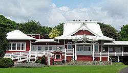
| 33 |
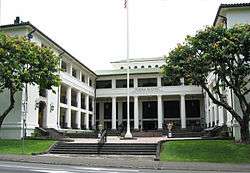
Huliheʻe Palace |
|
May 25, 1973
(#73000653) |
Aliʻi Drive
19°38′32″N 155°59′51″W / 19.642222°N 155.9975°W / 19.642222; -155.9975 (Huliheʻe Palace) |
Kailua-Kona |
Built by Governor Kuakini |
| 34 |
Imiola Church |
|
August 28, 1975
(#75000618) |
Northeast of Waimea on Hawaii Route 19
20°01′50″N 155°39′56″W / 20.030556°N 155.665556°W / 20.030556; -155.665556 (Imiola Church) |
Waimea |
1855 church with solid koa wood interior |
| 35 |
Kahaluu Historic District |
|
December 27, 1974
(#74000713) |
Address Restricted
|
Holualoa |
Complex of temples and royal residences |
| 36 |
Kahikolu Church |
|
November 15, 1982
(#82000148) |
Southeast of Napoopoo
19°28′10″N 155°54′55″W / 19.469444°N 155.915278°W / 19.469444; -155.915278 (Kahikolu Church) |
Napoopoo |
Built in 1852 on ruins of 1833 church |
| 37 |
Kalaoa Permanent House Site 10,205 |
|
November 21, 1992
(#92001552) |
Near Kalihi Point, Natural Energy Laboratory of Hawaii
19°43′35″N 156°03′31″W / 19.726389°N 156.058611°W / 19.726389; -156.058611 (Kalaoa Permanent House Site 10,205) |
Kailua-Kona |
Ancient house site |
| 38 |
Kaloko-Honokohau National Historical Park |
|
November 10, 1978
(#78003148) |
Island of Hawaii
19°41′05″N 156°01′22″W / 19.684697°N 156.022683°W / 19.684697; -156.022683 (Kaloko-Honokohau National Historical Park) |
Kailua-Kona |
Ancient fish ponds and settlement ruins |
| 39 |
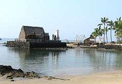
Kamakahonu, Residence Of King Kamehameha I |
|
October 15, 1966
(#66000288) |
On the northwestern edge of Kailua Bay, north and west of Kailua Wharf
19°38′20″N 155°59′51″W / 19.639006°N 155.997586°W / 19.639006; -155.997586 (Kamakahonu, Residence Of King Kamehameha I) |
Kailua-Kona |
Kamehameha I lived here after unifying the islands |
| 40 |
Kamehameha Hall |
|
May 20, 1993
(#93000426) |
1162 Kalanianaole Ave.
19°43′53″N 155°02′42″W / 19.731389°N 155.045°W / 19.731389; -155.045 (Kamehameha Hall) |
Hilo |
Meeting house of the Royal Order of Kamehameha I |
| 41 |
Kamehameha III's Birthplace |
|
July 24, 1978
(#78001018) |
Off Alii Dr.
19°34′00″N 155°57′50″W / 19.566667°N 155.963889°W / 19.566667; -155.963889 (Kamehameha III's Birthplace) |
Keauhou |
Marker at Keauhou Bay |
| 42 |
Kamoa Point Complex |
|
July 14, 1983
(#83000247) |
Address Restricted
|
Kailua-Kona |
Royal complex on Holualoa Bay |
| 43 |
Kealakekua Bay Historical District |
|
December 12, 1973
(#73000651) |
Southwest of Captain Cook off Hawaii Route 11
19°28′29″N 155°55′27″W / 19.474722°N 155.924167°W / 19.474722; -155.924167 (Kealakekua Bay Historical District) |
Captain Cook |
Religious center in use during early European visits |
| 44 |
Keauhou Holua Slide |
|
October 15, 1966
(#66000290) |
East of Hawaii Route 18
19°33′44″N 155°57′30″W / 19.562342°N 155.958472°W / 19.562342; -155.958472 (Keauhou Holua Slide) |
Keauhou |
Hawaiian lava sledding "extreme sport" course |
| 45 |
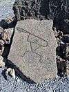
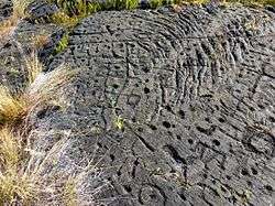
Kii Petroglyphs |
|
July 12, 1984
(#84000919) |
Address Restricted
|
Waiohinu |
|
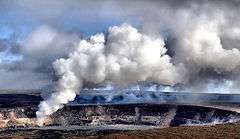
| 46 |
Kilauea Crater |
|
July 24, 1974
(#74000291) |
Southwest of Hilo in Hawaii Volcanoes National Park
19°25′02″N 155°16′36″W / 19.417222°N 155.276667°W / 19.417222; -155.276667 (Kilauea Crater) |
Hilo |
Active volcano is a world heritage site |
| 47 |
Kohala District Courthouse |
|
August 31, 1979
(#79000754) |
Government Rd.
20°13′59″N 155°48′03″W / 20.233056°N 155.800833°W / 20.233056; -155.800833 (Kohala District Courthouse) |
Kapaau |
|
| 48 |
Kuamo'o Burials |
|
August 13, 1974
(#74000714) |
Address Restricted
|
Kailua-Kona |
Site of 1819 battle, South of Keauhou Bay |
| 49 |
Lapakahi Complex |
|
July 2, 1973
(#73000654) |
Akoni Pule Highway
20°10′31″N 155°53′50″W / 20.175278°N 155.897222°W / 20.175278; -155.897222 (Lapakahi Complex) |
Mahukona |
Reconstructed ancient fishing village; State Historical Park and Marine Life Conservation District |
| 50 |
Levi and Netti Lyman House |
|
February 28, 2011
(#11000059) |
40 Halaulani Place
19°43′57″N 155°05′33″W / 19.7325°N 155.0925°W / 19.7325; -155.0925 (Levi and Netti Lyman House) |
Hilo |
Halaulani Place, 1917-1960 MPS; Colonial revival built 1922 |
| 51 |
Rev. D.B. Lyman House |
|
March 24, 1978
(#78001012) |
276 Haili St.
19°43′38″N 155°05′35″W / 19.727222°N 155.093056°W / 19.727222; -155.093056 (Rev. D.B. Lyman House) |
Hilo |
1838 missionary house is now a museum |
| 52 |
Mahana Archeological District (50HA10230) |
|
October 14, 1986
(#86002802) |
Address Restricted
|
Naalehu |
|
| 53 |
Manuka Bay Petroglyphs |
|
September 19, 1973
(#73000656) |
Address Restricted
|
Waiohinu |
|
| 54 |
Mauna Kea Adz Quarry |
|
October 15, 1966
(#66000285) |
Mauna Kea
National Park Service website; the NRIS lists it as "Address Restricted"
|
Hilo |
The largest primitive basalt quarry in the world |
| 55 |
Mauna Loa Road |
|
January 14, 2015
(#09000620) |
Hawaii Volcanoes National Park
19°26′15″N 155°18′10″W / 19.4374°N 155.3027°W / 19.4374; -155.3027 (Mauna Loa Road) |
Hilo vicinity |
|
| 56 |
Mokuaikaua Church |
|
October 3, 1978
(#78001015) |
Off Hawaii Route 11
19°38′39″N 155°59′48″W / 19.644167°N 155.996667°W / 19.644167; -155.996667 (Mokuaikaua Church) |
Kailua-Kona |
Oldest Christian Church in Hawaii |
| 57 |
Mookini Heiau |
|
October 15, 1966
(#66000284) |
Northern tip of Hawaii, 1 mile west of Upolu Point Airport
20°15′44″N 155°52′59″W / 20.262222°N 155.883056°W / 20.262222; -155.883056 (Mookini Heiau) |
Hawi |
State Monument includes Kamehameha I birthplace |
| 58 |
Edward H. and Claire Moses House |
|
February 28, 2011
(#11000056) |
105 Halaulani Place
19°43′59″N 155°05′32″W / 19.733056°N 155.092222°W / 19.733056; -155.092222 (Edward H. and Claire Moses House) |
Hilo |
Halaulani Place, 1917-1960 MPS; Craftsman bungalow built 1921 |
| 59 |
A. Nanbu Hotel-Holy's Bakery |
|
November 18, 1999
(#99001356) |
Akoni Pule Highway
20°13′55″N 155°47′57″W / 20.231944°N 155.799167°W / 20.231944; -155.799167 (A. Nanbu Hotel-Holy's Bakery) |
Kapaau |
|
| 60 |
Old Volcano House No. 42 |
|
July 24, 1974
(#74000293) |
Southwest of Hilo on Hawaii Route 11 in Hawaii Volcanoes National Park
19°25′49″N 155°15′30″W / 19.430221°N 155.258207°W / 19.430221; -155.258207 (Old Volcano House No. 42) |
Hilo |
Built in 1877; now Volcano Art Center gallery |
| 61 |
Palace Theater |
|
May 11, 1993
(#93000376) |
38 Haili St.
19°43′28″N 155°05′11″W / 19.724444°N 155.086389°W / 19.724444; -155.086389 (Palace Theater) |
Hilo |
A movie theater built in 1925, today an arthouse |
| 62 |
James and Catherine Parker House |
|
February 28, 2011
(#11000058) |
72 Halaulani Place
19°43′58″N 155°05′29″W / 19.732778°N 155.091389°W / 19.732778; -155.091389 (James and Catherine Parker House) |
Hilo |
Halaulani Place, 1917-1960 MPS; Craftsman bungalow built 1924 |
| 63 |
Pu'uhonua O Honaunau National Historical Park |
|
October 15, 1966
(#66000104) |
20 miles south of Kailua-Kona
19°25′22″N 155°54′35″W / 19.42277°N 155.90973°W / 19.42277; -155.90973 (Pu'uhonua O Honaunau National Historical Park) |
Hōnaunau |
Large ancient religious site formerly known as the "City of Refuge" |
| 64 |
Pu'ukohola Heiau |
|
October 15, 1966
(#07001173) |
0.9 miles southeast of Kawaihae
20°01′35″N 155°49′12″W / 20.026389°N 155.82°W / 20.026389; -155.82 (Pu'ukohola Heiau) |
Kawaihae |
Kamehameha I temple built in 1790 |
| 65 |
Pu'ukohola Heiau National Historic Site |
|
August 17, 1972
(#66000105) |
Northern end of Hawaii off Hawaii Route 26, about 1 mile southeast of Kawaihae
20°01′52″N 155°49′30″W / 20.031111°N 155.825°W / 20.031111; -155.825 (Pu'ukohola Heiau National Historic Site) |
Kawaihae |
see above |
| 66 |
Pua'a-2 Agricultural Fields Archeological District |
|
October 14, 1986
(#86002804) |
Address Restricted
|
Holualoa |
Potentially destroyed[3] |
| 67 |
Puako Petroglyph Archeological District |
|
June 6, 2007
(#83000248) |
Address Restricted
|
Puako |
|
| 68 |
Puna-Ka'u Historic District |
|
July 1, 1974
(#74000294) |
Hawaii Volcanoes National Park
19°17′42″N 155°14′31″W / 19.295°N 155.241944°W / 19.295; -155.241944 (Puna-Ka'u Historic District) |
Pāhala |
|
| 69 |
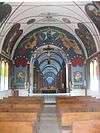
St. Benedict's Catholic Church |
|
May 31, 1979
(#79000753) |
Off Hawaii Route 11
19°26′21″N 155°53′33″W / 19.439167°N 155.8925°W / 19.439167; -155.8925 (St. Benedict's Catholic Church) |
Hōnaunau |
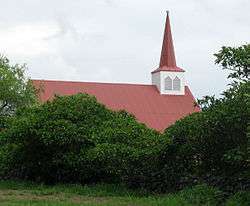
Another "Painted Church" |
| 70 |
Masaaki Sakata Property |
|
August 7, 2017
(#100001414) |
45-3577 Mamane St.
20°04′44″N 155°28′05″W / 20.078976°N 155.467973°W / 20.078976; -155.467973 (Masaaki Sakata Property) |
Honokaʻa |
|
| 71 |
W.H. Shipman House |
|
June 23, 1978
(#78001013) |
141 Kaʻiulani Street
19°43′27″N 155°05′58″W / 19.724167°N 155.099444°W / 19.724167; -155.099444 (W.H. Shipman House) |
Hilo |
Built in 1899 for William Herbert Shipman, now a "Bed and Breakfast" Hotel |
| 72 |
South Point Complex |
|
October 15, 1966
(#66000291) |
Southern point of Hawaii
18°54′57″N 155°40′35″W / 18.915833°N 155.676389°W / 18.915833; -155.676389 (South Point Complex) |
Naalehu |
Southernmost point in the United States |
| 73 |
Star of the Sea Church-Kalapana Painted Church |
|
May 14, 1997
(#97000407) |
Hawaii Route 130, 0.7 miles north of Kaimu
19°22′34″N 154°58′01″W / 19.376111°N 154.966944°W / 19.376111; -154.966944 (Star of the Sea Church-Kalapana Painted Church) |
Kaimu |
Small church near villages destroyed by lava flows |
| 74 |
Tong Wo Society Building |
|
June 9, 1978
(#78001011) |
Hawaii Route 27
20°13′40″N 155°46′10″W / 20.227778°N 155.769444°W / 20.227778; -155.769444 (Tong Wo Society Building) |
Halaula |
|
| 75 |
Herbert Austin Truslow House |
|
February 28, 2011
(#11000060) |
52 Halaulani Place
19°43′57″N 155°05′31″W / 19.7325°N 155.091944°W / 19.7325; -155.091944 (Herbert Austin Truslow House) |
Hilo |
Halaulani Place, 1917-1960 MPS; Craftsman bungalow built 1920 |
| 76 |
U.S. Post Office and Office Building |
|
October 1, 1974
(#74000708) |
Kinoole and Waianuenue Sts.
19°43′49″N 155°05′31″W / 19.730278°N 155.091944°W / 19.730278; -155.091944 (U.S. Post Office and Office Building) |
Hilo |
Built in 1915, still used as Federal offices |
| 77 |
Uchida Coffee Farm |
|
February 9, 1995
(#94001621) |
Off Mamalahoa Highway
19°29′24″N 155°54′49″W / 19.49°N 155.913611°W / 19.49; -155.913611 (Uchida Coffee Farm) |
Kealakekua |
Restored Japanese Kona coffee farm |
| 78 |
Volcano Block Building |
|
January 7, 1993
(#92001748) |
27-37 Waianuenue Ave.
19°43′44″N 155°05′24″W / 19.728889°N 155.09°W / 19.728889; -155.09 (Volcano Block Building) |
Hilo |
Commercial building built in 1914 with notable tenants |
| 79 |
Waiakea Mission Station-Hilo Station |
|
April 23, 2002
(#02000387) |
211 Haili St.
19°43′37″N 155°05′31″W / 19.726944°N 155.091944°W / 19.726944; -155.091944 (Waiakea Mission Station-Hilo Station) |
Hilo |
Haili Church built by Titus Coan 1854 |
| 80 |
Waimea Elementary School |
|
June 8, 2005
(#05000541) |
Hawaii Route 19, Kawaihae Rd. TMK (3)6-5-07:3
20°01′25″N 155°40′21″W / 20.023611°N 155.6725°W / 20.023611; -155.6725 (Waimea Elementary School) |
Kamuela |
First schoolhouse serving Waimea community and example of early Hawaiian plantation style |
| 81 |
Whitney Seismograph Vault No. 29 |
|
July 24, 1974
(#74000292) |
Southwest of Hilo on Hawaii Route 11 in Hawaii Volcanoes National Park
19°25′59″N 155°15′40″W / 19.433056°N 155.261111°W / 19.433056; -155.261111 (Whitney Seismograph Vault No. 29) |
Hilo |
Original home of Hawaiian Volcano Observatory founded by Thomas Jaggar in 1912 |
| 82 |
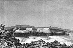
Wilkes Campsite |
|
July 24, 1974
(#74000295) |
West of Hilo at Mauna Loa Volcano in Hawaii Volcanoes National Park
19°28′14″N 155°35′06″W / 19.470556°N 155.585°W / 19.470556; -155.585 (Wilkes Campsite) |
Hilo |
Ruins of 1840 Charles Wilkes camp site at Mokuaweoweo summit |
| 83 |
A.J. Williamson House |
|
May 9, 1997
(#97000406) |
31 Halaulani Pl.
19°44′11″N 155°05′44″W / 19.736389°N 155.095556°W / 19.736389; -155.095556 (A.J. Williamson House) |
Hilo |
Craftsman bungalow built 1921 |
| 84 |
Teiji Yamatsuka Store |
|
March 12, 2018
(#100001415) |
45-3590 Mamane St.
20°04′45″N 155°28′06″W / 20.079213°N 155.468410°W / 20.079213; -155.468410 (Teiji Yamatsuka Store) |
Honokaʻa |
|
.svg.png)
.tif.jpg)
.tif.jpg)