Fruita Rural Historic District
|
Fruita Rural Historic District | |
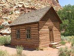 Fruita schoolhouse | |
  | |
| Nearest city | Torrey, Utah |
|---|---|
| Coordinates | 38°17′6″N 111°15′7″W / 38.28500°N 111.25194°WCoordinates: 38°17′6″N 111°15′7″W / 38.28500°N 111.25194°W |
| Built | 1883 |
| Architect | multiple |
| NRHP reference # | 97000246[1] |
| Added to NRHP | March 25, 1997[2] |
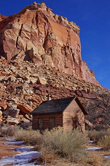
The Fruita Rural Historic District in Capitol Reef National Park comprises a former Mormon agricultural settlement that was active from 1895 to 1947. It includes what remains of the town of Fruita, Utah. The Leo R. Holt House, oldest in Fruita, was built in 1895 and the Fruita schoolhouse in 1896. Along with other scattered structures from the original settlement, the district also includes the 1940 ranger station, built for what was then Capitol Reef National Monument in the National Park Service Rustic style and constructed by the Civilian Conservation Corps. Later development included the Mission 66 park visitor center.[3]
The orchards that gave Fruita its name are preserved as a "historic landscape" by the National Park Service.
References
- ↑ National Park Service (2009-03-13). "National Register Information System". National Register of Historic Places. National Park Service.
- ↑ National Park Service (2008-04-15). "National Register Information System". National Register of Historic Places. National Park Service.
- ↑ "Ranger Station". List of Classified Structures. National Park Service. Retrieved 2 Mar 2009.
External links
![]()
| Topics | |
|---|---|
| Lists by states |
|
| Lists by insular areas | |
| Lists by associated states | |
| Other areas | |
| |