National Register of Historic Places listings in Jefferson County, Oklahoma
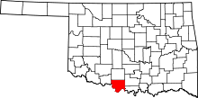
Location of Jefferson County in Oklahoma
This is a list of the National Register of Historic Places listings in Jefferson County, Oklahoma.
This is intended to be a complete list of the properties on the National Register of Historic Places in Jefferson County, Oklahoma, United States. The locations of National Register properties for which the latitude and longitude coordinates are included below, may be seen in a map.[1]
There are 7 properties listed on the National Register in the county.
- This National Park Service list is complete through NPS recent listings posted October 11, 2018.[2]
Current listings
| [3] | Name on the Register[4] | Image | Date listed[5] | Location | City or town | Description |
|---|---|---|---|---|---|---|
| 1 | Archeological Site 34JF109 | December 13, 2010 (#10001014) |
Address Restricted |
Belleville | ||
| 2 | First Presbyterian Church | 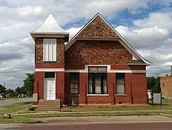 |
March 13, 2002 (#02000175) |
124 West Broadway 34°09′54″N 98°00′07″W / 34.165°N 98.001944°W |
Waurika | |
| 3 | Irving Baptist Church | .jpg) |
December 3, 2009 (#09000977) |
Junction of E2050 and N2770 Roads 34°02′30″N 98°03′10″W / 34.04155°N 98.05272°W |
Ryan | Rural church built in 1928. |
| 4 | Jefferson County Courthouse | 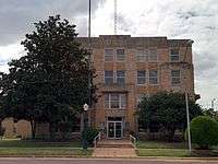 |
August 23, 1984 (#84003065) |
N. Main St. 34°09′56″N 98°00′04″W / 34.165556°N 98.001111°W |
Waurika | |
| 5 | Rock Island Passenger Station | 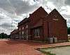 |
March 13, 2002 (#02000173) |
105 S. Meridian 34°09′46″N 97°59′57″W / 34.162778°N 97.999167°W |
Waurika | |
| 6 | San Bernardo | March 10, 1982 (#82003685) |
Address Restricted |
Ringling | ||
| 7 | State Highway 79 Bridge at the Red River | 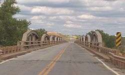 |
December 20, 1996 (#96001518) |
State Highway 79 across the Red River at the Oklahoma-Texas state line 34°07′58″N 98°05′26″W / 34.132778°N 98.090556°W |
Byers | Extends into Clay County, Texas |
See also
| Wikimedia Commons has media related to National Register of Historic Places in Jefferson County, Oklahoma. |
References
- ↑ The latitude and longitude information provided in this table was derived originally from the National Register Information System, which has been found to be fairly accurate for about 99% of listings. For about 1% of NRIS original coordinates, experience has shown that one or both coordinates are typos or otherwise extremely far off; some corrections may have been made. A more subtle problem causes many locations to be off by up to 150 yards, depending on location in the country: most NRIS coordinates were derived from tracing out latitude and longitudes from USGS topographical quadrant maps created under the North American Datum of 1927, which differs from the current, highly accurate WGS84 GPS system used by most on-line maps. Chicago is about right, but NRIS longitudes in Washington are higher by about 4.5 seconds, and are lower by about 2.0 seconds in Maine. Latitudes differ by about 1.0 second in Florida. Some locations in this table may have been corrected to current GPS standards.
- ↑ "National Register of Historic Places: Weekly List Actions". National Park Service, United States Department of the Interior. Retrieved on October 11, 2018.
- ↑ Numbers represent an ordering by significant words. Various colorings, defined here, differentiate National Historic Landmarks and historic districts from other NRHP buildings, structures, sites or objects.
- ↑ National Park Service (2009-03-13). "National Register Information System". National Register of Historic Places. National Park Service.
- ↑ The eight-digit number below each date is the number assigned to each location in the National Register Information System database, which can be viewed by clicking the number.
| Topics | |
|---|---|
| Lists by states |
|
| Lists by insular areas | |
| Lists by associated states | |
| Other areas | |
| |
This article is issued from
Wikipedia.
The text is licensed under Creative Commons - Attribution - Sharealike.
Additional terms may apply for the media files.