Grady, Oklahoma
| Grady | |
|---|---|
| Unincorporated community | |
 Grady Location within the state of Oklahoma  Grady Grady (the US) | |
| Coordinates: 34°1′13″N 97°39′56″W / 34.02028°N 97.66556°WCoordinates: 34°1′13″N 97°39′56″W / 34.02028°N 97.66556°W | |
| Country | United States |
| State | Oklahoma |
| County | Jefferson |
| Elevation | 850 ft (260 m) |
| Time zone | UTC-6 (Central (CST)) |
| • Summer (DST) | UTC-5 (CDT) |
| ZIP codes | 73569 |
Grady is a small rural unincorporated community in southeastern Jefferson County, Oklahoma, United States, along State Highway 32. The post office opened June 16, 1890. The ZIP Code is 73569. Grady is said to have been named for Henry W. Grady.
Sources
- Shirk, George H. Oklahoma Place Names. Norman: University of Oklahoma Press, 1987. ISBN 0-8061-2028-2 .
Municipalities and communities of Jefferson County, Oklahoma, United States | ||
|---|---|---|
| City | 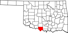 | |
| Towns | ||
| Unincorporated communities | ||
This article is issued from
Wikipedia.
The text is licensed under Creative Commons - Attribution - Sharealike.
Additional terms may apply for the media files.