| [3] |
Name on the Register[4] |
Image |
Date listed[5] |
Location |
City or town |
Description |
|---|
| 1 |
One-hundred-and-one Ranch |
|
April 11, 1973
(#73001560) |
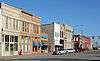
12 miles southwest of Ponca City on State Highway 156
36°36′47″N 97°08′34″W / 36.613056°N 97.142778°W / 36.613056; -97.142778 (One-hundred-and-one Ranch) |
Ponca City |
|
| 2 |
101 Rodeo Arena |
|
December 4, 2017
(#100001865) |
2600 N Ash St.
36°43′11″N 97°05′39″W / 36.719781°N 97.094204°W / 36.719781; -97.094204 (101 Rodeo Arena) |
Ponca City |
|
| 3 |
Attucks Community Center |
|
December 4, 2017
(#100001866) |
1001 S 12th St.
36°41′35″N 97°04′12″W / 36.693048°N 97.069871°W / 36.693048; -97.069871 (Attucks Community Center) |
Ponca City |
|
| 4 |
Bennie L. Aupperle Dairy Barn |
|
December 12, 2012
(#12001038) |
8700 N. La Cann Rd.
36°55′17″N 97°01′49″W / 36.92136°N 97.0303°W / 36.92136; -97.0303 (Bennie L. Aupperle Dairy Barn) |
Newkirk |
|
| 5 |
Big V Ranch House |
|
August 23, 1984
(#84003068) |
Off State Highway 156
36°37′09″N 97°10′31″W / 36.619167°N 97.175278°W / 36.619167; -97.175278 (Big V Ranch House) |
Ponca City |
|
| 6 |
Blackwell Armory |
|
September 8, 1988
(#88001366) |
6th St. and Doolin Avenue
36°48′40″N 97°17′28″W / 36.811111°N 97.291111°W / 36.811111; -97.291111 (Blackwell Armory) |
Blackwell |
|
| 7 |
Blaine Stadium and Fieldhouse |
|
September 8, 1988
(#88001364) |
5th and Brookfield Sts.
36°43′06″N 97°04′38″W / 36.718333°N 97.077222°W / 36.718333; -97.077222 (Blaine Stadium and Fieldhouse) |
Ponca City |
|
| 8 |
Bryson Archeological Site |
|
September 20, 1979
(#79001997) |
Address Restricted
|
Newkirk |
|
| 9 |
Chilocco Indian Agricultural School |
|
September 8, 2006
(#06000792) |
U.S. Route 77 and E0018 Rd.
36°59′06″N 97°03′45″W / 36.985°N 97.0625°W / 36.985; -97.0625 (Chilocco Indian Agricultural School) |
Newkirk |
|
| 10 |
Darr School of Aeronautics Hangar No. 3 |
|
September 8, 2006
(#06000794) |
Southwest of the junction of Darr Park Dr. and Lindsey Rd.
36°44′10″N 97°05′50″W / 36.736111°N 97.097222°W / 36.736111; -97.097222 (Darr School of Aeronautics Hangar No. 3) |
Ponca City |
|
| 11 |
Deer Creek Site |
|
October 15, 1966
(#66000630) |
Address Restricted
|
Newkirk |
|
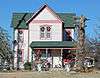
| 12 |
Daniel J. Donahoe House |
|
March 10, 1982
(#82003686) |
302 S. 7th St.
36°42′04″N 97°04′33″W / 36.701111°N 97.075833°W / 36.701111; -97.075833 (Daniel J. Donahoe House) |
Ponca City |
|
| 13 |
Downtown Ponca City Historic District |
|
March 21, 2011
(#10001010) |
Roughly bounded by Pine St., Chestnut St., 7th St., and Central Ave.
36°42′15″N 97°04′52″W / 36.704167°N 97.081111°W / 36.704167; -97.081111 (Downtown Ponca City Historic District) |
Ponca City |
|
| 14 |
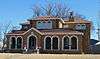
Electric Park Pavilion |
|
September 29, 1976
(#76001563) |
300 S. Main
36°48′06″N 97°16′54″W / 36.801667°N 97.281667°W / 36.801667; -97.281667 (Electric Park Pavilion) |
Blackwell |
|
| 15 |
First Church of Christ, Scientist |
|
March 9, 2015
(#15000063) |
300 N. 3rd St.
36°42′21″N 97°04′52″W / 36.7059°N 97.0811°W / 36.7059; -97.0811 (First Church of Christ, Scientist) |
Ponca City |
|
| 16 |
First Presbyterian Church of Tonkawa |
|
September 22, 1994
(#94001081) |
109 S. 4th St.
36°40′43″N 97°18′18″W / 36.678611°N 97.305°W / 36.678611; -97.305 (First Presbyterian Church of Tonkawa) |
Tonkawa |
|
| 17 |
Henry C. Hatashita House |
|
December 13, 2016
(#16000848) |
1408 Pioneer Rd.
36°42′53″N 97°03′58″W / 36.714620°N 97.066246°W / 36.714620; -97.066246 (Henry C. Hatashita House) |
Ponca City |
|
| 18 |
Hayes-Kennedy-Rivoli Theater Building |
|
June 8, 2015
(#15000327) |
122-124 S. Main
36°48′12″N 97°16′59″W / 36.8034°N 97.283°W / 36.8034; -97.283 (Hayes-Kennedy-Rivoli Theater Building) |
Blackwell |
|
| 19 |
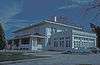
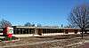
Huston Elementary School |
|
March 4, 2009
(#09000073) |
304 Vinnedge Ave.
36°47′11″N 97°17′12″W / 36.786389°N 97.286667°W / 36.786389; -97.286667 (Huston Elementary School) |
Blackwell |
|
| 20 |
Gov. William W. Jenkins Homestead Site |
|
October 14, 1976
(#76001564) |
Address Restricted
|
Newkirk |
|
| 21 |
Kaw City Depot |
|
October 3, 1979
(#79001996) |
West of Kaw City on Washungah Dr.
36°45′53″N 96°51′29″W / 36.764722°N 96.858056°W / 36.764722; -96.858056 (Kaw City Depot) |
Kaw City |
|
| 22 |
Kaw Indian Agency |
|
April 11, 1973
(#73001562) |
North of the Arkansas River
36°46′36″N 96°50′00″W / 36.776667°N 96.833333°W / 36.776667; -96.833333 (Kaw Indian Agency) |
Washunga |
|
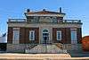
| 23 |
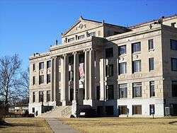
Kay County Courthouse |
|
August 23, 1984
(#84003070) |
Courthouse Square
36°52′51″N 97°03′14″W / 36.880833°N 97.053889°W / 36.880833; -97.053889 (Kay County Courthouse) |
Newkirk |
|
| 24 |
Lake Ponca Duck Pond Historic District |
|
December 8, 2015
(#15000872) |
L.A. Cann Dr. & Edam Rd.
36°43′06″N 97°01′33″W / 36.718388°N 97.025894°W / 36.718388; -97.025894 (Lake Ponca Duck Pond Historic District) |
Ponca City |
|
| 25 |
Larkin Hotel |
|
December 18, 2013
(#13000940) |
201 N. Main St.
36°48′20″N 97°17′00″W / 36.805461°N 97.283396°W / 36.805461; -97.283396 (Larkin Hotel) |
Blackwell |
|
| 26 |
Mahoney House and Garage |
|
July 3, 1984
(#84003074) |
302 N. Main Ave.
36°40′53″N 97°18′33″W / 36.681389°N 97.309167°W / 36.681389; -97.309167 (Mahoney House and Garage) |
Tonkawa |
|
| 27 |
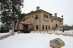
E. W. Marland Mansion |
|
April 11, 1973
(#73001561) |
Monument Rd.
36°43′00″N 97°03′37″W / 36.716667°N 97.060278°W / 36.716667; -97.060278 (E. W. Marland Mansion) |
Ponca City |
|
| 28 |
Marland-Paris House |
|
September 28, 1976
(#76001565) |
1000 E. Grand
36°42′11″N 97°04′17″W / 36.703056°N 97.071389°W / 36.703056; -97.071389 (Marland-Paris House) |
Ponca City |
|
| 29 |
James J. McGraw House |
|
December 4, 2017
(#100001867) |
400 N. 4th St.
36°42′25″N 97°04′47″W / 36.706999°N 97.079807°W / 36.706999; -97.079807 (James J. McGraw House) |
Ponca City |
|
| 30 |
Newkirk Central Business District |
|
February 23, 1984
(#84003079) |
Main and 7th Sts.
36°54′01″N 97°03′10″W / 36.900278°N 97.052778°W / 36.900278; -97.052778 (Newkirk Central Business District) |
Newkirk |
|
| 31 |
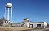
Newkirk Water Purification Plant |
|
September 8, 1988
(#88001365) |
10th and Elm Sts.
36°52′44″N 97°03′04″W / 36.878889°N 97.051111°W / 36.878889; -97.051111 (Newkirk Water Purification Plant) |
Newkirk |
|
| 32 |
Nez Perce Reservation |
|
February 15, 1974
(#74001663) |
Address Restricted
|
Tonkawa |
|
| 33 |
Northside Elementary School |
|
February 23, 2009
(#09000074) |
720 W. Doolin Ave.
36°48′41″N 97°17′33″W / 36.811389°N 97.2925°W / 36.811389; -97.2925 (Northside Elementary School) |
Blackwell |
|
| 34 |
Parkside Elementary School |
|
February 23, 2009
(#09000075) |
502 E. College Ave.
36°48′05″N 97°16′36″W / 36.801389°N 97.276667°W / 36.801389; -97.276667 (Parkside Elementary School) |
Blackwell |
|
| 35 |
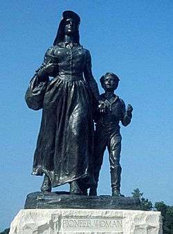
Pioneer Woman Statue |
|
August 31, 1978
(#78002238) |
Monument Circle
36°42′36″N 97°03′55″W / 36.71°N 97.065278°W / 36.71; -97.065278 (Pioneer Woman Statue) |
Ponca City |
|
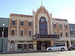
| 36 |
Poncan Theatre |
|
November 13, 1984
(#84000455) |
104 E. Grand Ave.
36°42′11″N 97°04′58″W / 36.703056°N 97.082778°W / 36.703056; -97.082778 (Poncan Theatre) |
Ponca City |
|
| 37 |
Roosevelt Elementary School |
|
December 4, 2017
(#100001868) |
815 E. Highland Ave.
36°42′35″N 97°04′25″W / 36.709646°N 97.073609°W / 36.709646; -97.073609 (Roosevelt Elementary School) |
Ponca City |
|
| 38 |
St. John Baptist Church and Rectory |
|
March 9, 2015
(#15000064) |
1009 S. 11th St.
36°41′35″N 97°04′16″W / 36.6930°N 97.0711°W / 36.6930; -97.0711 (St. John Baptist Church and Rectory) |
Ponca City |
|
| 39 |
Santa Fe Depot |
|
March 12, 2012
(#12000113) |
Near junction of S. 1st & W. Oklahoma
36°42′06″N 97°05′02″W / 36.701587°N 97.083866°W / 36.701587; -97.083866 (Santa Fe Depot) |
Ponca City |
|
| 40 |
Sheets House |
|
September 8, 2011
(#11000639) |
1350 Peckham Rd
36°53′01″N 97°04′10″W / 36.883611°N 97.069444°W / 36.883611; -97.069444 (Sheets House) |
Newkirk |
|
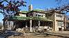
| 41 |
Soldani Mansion |
|
June 24, 1982
(#82003687) |
819 E. Central Avenue
36°42′09″N 97°04′25″W / 36.7025°N 97.073611°W / 36.7025; -97.073611 (Soldani Mansion) |
Ponca City |
Now the Ponca City Art Center. |
| 42 |
J.P. Tipton Farmstead |
|
February 5, 1998
(#98000073) |
3.1 miles east of Newkirk
36°53′01″N 96°59′08″W / 36.883611°N 96.985556°W / 36.883611; -96.985556 (J.P. Tipton Farmstead) |
Newkirk |
|
| 43 |
Tonkawa Armory |
|
September 8, 1988
(#88001363) |
3rd and North Sts.
36°41′25″N 97°18′10″W / 36.690278°N 97.302778°W / 36.690278; -97.302778 (Tonkawa Armory) |
Tonkawa |
|
| 44 |
Tonkawa Lodge No. 157 A.F. & A.M. |
|
September 6, 2007
(#07000910) |
112 N. 7th St.
36°40′45″N 97°18′28″W / 36.679167°N 97.307778°W / 36.679167; -97.307778 (Tonkawa Lodge No. 157 A.F. & A.M.) |
Tonkawa |
|
| 45 |
Washington Elementary School |
|
March 4, 2009
(#09000076) |
723 W. College Ave.
36°48′05″N 97°17′32″W / 36.801389°N 97.292222°W / 36.801389; -97.292222 (Washington Elementary School) |
Blackwell |
|
| 46 |
Wentz Camp |
|
September 3, 2010
(#10000620) |
Intersection of L.A. Cann Dr. and E. Prospect Ave.
36°44′18″N 97°01′33″W / 36.738333°N 97.025833°W / 36.738333; -97.025833 (Wentz Camp) |
Ponca City |
|
| 47 |
White Eagle Park |
|
June 8, 2007
(#07000522) |
North of White Eagle
36°36′30″N 97°04′16″W / 36.608315°N 97.07112°W / 36.608315; -97.07112 (White Eagle Park) |
White Eagle |
|