National Register of Historic Places listings in Cleveland County, Oklahoma
Location of Cleveland County in Oklahoma
This is a list of the National Register of Historic Places listings in Cleveland County, Oklahoma.
This is intended to be a complete list of the properties and districts on the National Register of Historic Places in Cleveland County, Oklahoma, United States. The locations of National Register properties and districts for which the latitude and longitude coordinates are included below, may be seen in a map.[1]
There are 25 properties and districts listed on the National Register in the county, including 1 National Historic Landmark.
- This National Park Service list is complete through NPS recent listings posted October 11, 2018.[2]
Current listings
| [3] | Name on the Register[4] | Image | Date listed[5] | Location | City or town | Description |
|---|---|---|---|---|---|---|
| 1 | Beta Theta Pi Fraternity House, The University of Oklahoma |  |
June 2, 1982 (#82003675) |
800 S. Chautauqua Ave. 35°12′26″N 97°27′00″W / 35.207222°N 97.45°W |
Norman | |
| 2 | Bizzell Library, University of Oklahoma |  |
January 3, 2001 (#01000071) |
401 W. Brooks St. 35°12′27″N 97°26′46″W / 35.20749°N 97.44606°W |
Norman | |
| 3 | Casa Blanca | 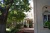 |
February 21, 1990 (#90000123) |
103 W. Boyd 35°12′40″N 97°26′28″W / 35.211111°N 97.441111°W |
Norman | |
| 4 | Cleveland County Courthouse | 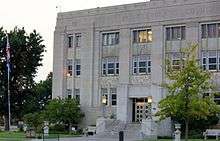 |
December 28, 2000 (#00001580) |
200 S. Peters Ave. 35°13′11″N 97°25′49″W / 35.219722°N 97.430278°W |
Norman | |
| 5 | DeBarr Historic District | 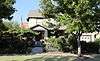 |
December 27, 1991 (#91001904) |
Roughly bounded by Boyd St., DeBarr Ave., Duffy St., and the former ATSF railroad tracks 35°12′44″N 97°26′25″W / 35.212222°N 97.440278°W |
Norman | |
| 6 | Downtown Norman Historic District | 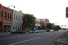 |
October 10, 1978 (#78002226) |
105 W. Main and 100-232 E. Main St.; also roughly bounded by Webster, Gray, Porter, Eufaula, James Garner, and Comanche 35°13′18″N 97°26′29″W / 35.221667°N 97.441389°W |
Norman | Second set of boundaries represents a boundary increase of March 12, 2012; originally listed as Norman Historic District |
| 7 | Patricio Gimeno House | 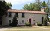 |
December 30, 1991 (#91001902) |
800 Elm St. 35°12′20″N 97°26′52″W / 35.205556°N 97.447778°W |
Norman | |
| 8 | Oscar B. Jacobson House | 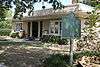 |
December 23, 1986 (#86003466) |
609 S. Chatauqua Ave. 35°12′39″N 97°26′58″W / 35.210833°N 97.449444°W |
Norman | |
| 9 | H.E. Ledbetter House | 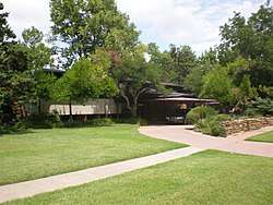 |
June 14, 2001 (#01000655) |
701 W. Brooks 35°12′27″N 97°27′04″W / 35.2075°N 97.451111°W |
Norman | |
| 10 | Logan Apartments | 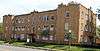 |
March 11, 2014 (#14000049) |
720 W. Boyd St. 35°12′39″N 97°27′04″W / 35.210923°N 97.451211°W |
Norman | |
| 11 | Mardock Mission | March 14, 1983 (#83002081) |
Southeast of Stella off State Highway 9 35°12′39″N 97°09′31″W / 35.210833°N 97.158611°W |
Stella | ||
| 12 | Moore Public School Building | 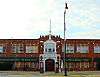 |
November 8, 1984 (#84000379) |
NW. 1st and Broadway 35°20′23″N 97°29′12″W / 35.339722°N 97.486667°W |
Moore | |
| 13 | Moore-Lindsay House | 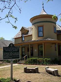 |
November 14, 1985 (#85002788) |
508 N. Peters 35°13′31″N 97°26′39″W / 35.225278°N 97.444167°W |
Norman | |
| 14 | Norman City Park New Deal Resources | 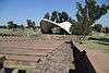 |
December 28, 2000 (#00001572) |
Junction of Daws St. and Webster Ave. 35°13′22″N 97°26′14″W / 35.222778°N 97.437222°W |
Norman | |
| 15 | Norman Public Library |  |
December 28, 2000 (#00001581) |
329 S. Peters Ave. 35°13′08″N 97°26′23″W / 35.218889°N 97.439722°W |
Norman | |
| 16 | Oklahoma Center for Continuing Education Historic District |  |
June 10, 2011 (#11000334) |
Bounded by Asp Ave., Kellogg Dr., Maple and 4th Sts. 35°11′54″N 97°26′44″W / 35.198333°N 97.445556°W |
Norman | |
| 17 | Park Etude | December 4, 2017 (#100001864) |
1028 Connelly Ln. 35°11′49″N 97°27′22″W / 35.197066°N 97.456002°W |
Norman | ||
| 18 | President's House, University of Oklahoma |  |
July 6, 1976 (#76001558) |
401 W. Boyd St. 35°12′42″N 97°26′46″W / 35.211567°N 97.446159°W |
Norman | |
| 19 | Santa Fe Depot | 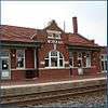 |
January 25, 1991 (#90002203) |
Junction of Abner Norman Dr. and Comanche St. 35°13′12″N 97°26′33″W / 35.22°N 97.4425°W |
Norman | |
| 20 | Sooner Theater Building | 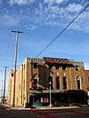 |
August 31, 1978 (#78002227) |
101 E. Main St. 35°13′17″N 97°26′34″W / 35.221389°N 97.442778°W |
Norman |
Southridge Addition Historic District, Roughly bounded by Classen Blvd., Oklahoma & S Ponca Aves., E Boyd, Macy & Okmulgee Sts., Norman, SG100002882, LISTED, 8/31/2018 |
| 21 | Southridge Addition Historic District | August 31, 2018 (#100002882) |
Roughly bounded by Classen Blvd., Oklahoma & S Ponca Aves., E Boyd, Macy & Okmulgee Sts. 35°12′40″N 97°26′05″W / 35.2112°N 97.4346°W |
Norman | ||
| 22 | US Highway 77 Bridge at Canadian River | 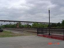 |
September 2, 2003 (#03000882) |
U.S. Route 77 over the Canadian River 35°00′53″N 97°20′52″W / 35.014656°N 97.347711°W |
Purcell | Extends into McClain County |
| 23 | Union School District 19 1/2 |  |
December 10, 2014 (#14001026) |
SW. corner of 149th St. & S. Luther Rd. 35°19′07″N 97°11′42″W / 35.3187°N 97.1951°W |
Newalla | |
| 24 | United States Post Office-Norman | December 28, 2000 (#00001573) |
207 E. Gray St. 35°13′22″N 97°26′32″W / 35.2228°N 97.4423°W |
Norman | ||
| 25 | University of Oklahoma Armory | 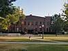 |
December 8, 2015 (#15000866) |
103 W. Brooks St. 35°12′25″N 97°26′38″W / 35.206919°N 97.443821°W |
Norman |
Former listings
| [3] | Name on the Register | Image | Date listed | Date removed | Location | City or town | Summary |
|---|---|---|---|---|---|---|---|
| 1 | Eugene Bavinger House | 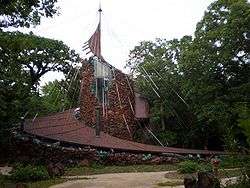 |
December 13, 2001 (#01001354) | February 28, 2017 | 730 60th Ave., NE. 35°13′40″N 97°21′10″W / 35.227778°N 97.352778°W |
Norman |
See also
| Wikimedia Commons has media related to National Register of Historic Places in Cleveland County, Oklahoma. |
References
- ↑ The latitude and longitude information provided in this table was derived originally from the National Register Information System, which has been found to be fairly accurate for about 99% of listings. For about 1% of NRIS original coordinates, experience has shown that one or both coordinates are typos or otherwise extremely far off; some corrections may have been made. A more subtle problem causes many locations to be off by up to 150 yards, depending on location in the country: most NRIS coordinates were derived from tracing out latitude and longitudes from USGS topographical quadrant maps created under the North American Datum of 1927, which differs from the current, highly accurate WGS84 GPS system used by most on-line maps. Chicago is about right, but NRIS longitudes in Washington are higher by about 4.5 seconds, and are lower by about 2.0 seconds in Maine. Latitudes differ by about 1.0 second in Florida. Some locations in this table may have been corrected to current GPS standards.
- ↑ "National Register of Historic Places: Weekly List Actions". National Park Service, United States Department of the Interior. Retrieved on October 11, 2018.
- 1 2 Numbers represent an ordering by significant words. Various colorings, defined here, differentiate National Historic Landmarks and historic districts from other NRHP buildings, structures, sites or objects.
- ↑ National Park Service (2009-03-13). "National Register Information System". National Register of Historic Places. National Park Service.
- ↑ The eight-digit number below each date is the number assigned to each location in the National Register Information System database, which can be viewed by clicking the number.
| Moore |
| |
|---|---|---|
| Newalla |
| |
| Norman |
| |
| Purcell | ||
| Stella | ||
| Topics | |
|---|---|
| Lists by states |
|
| Lists by insular areas | |
| Lists by associated states | |
| Other areas | |
| |
Municipalities and communities of Cleveland County, Oklahoma, United States | ||
|---|---|---|
| Cities | | |
| Towns | ||
| Neighborhood | ||
| Footnotes | ‡This populated place also has portions in an adjacent county or counties | |
This article is issued from
Wikipedia.
The text is licensed under Creative Commons - Attribution - Sharealike.
Additional terms may apply for the media files.