National Register of Historic Places listings in Choctaw County, Oklahoma
Location of Choctaw County in Oklahoma
This is a list of the National Register of Historic Places listings in Choctaw County, Oklahoma.
This is intended to be a complete list of the properties and districts on the National Register of Historic Places in Choctaw County, Oklahoma, United States. The locations of National Register properties and districts for which the latitude and longitude coordinates are included below, may be seen in a map.[1]
There are 13 properties and districts listed on the National Register in the county.
- This National Park Service list is complete through NPS recent listings posted October 11, 2018.[2]
Current listings
| [3] | Name on the Register[4] | Image | Date listed[5] | Location | City or town | Description |
|---|---|---|---|---|---|---|
| 1 | District Choctaw Chief's House | June 21, 1971 (#71000660) |
1.5 miles northeast of Swink 34°01′23″N 95°10′54″W / 34.023056°N 95.181667°W |
Swink | Built for the Appuckshunubbe District Chief, the 1830 Treaty of Dancing Rabbit Creek provided for its construction. This house at Swink is the only house still on its original site in existence from that era. Maintained by the Swink Historical Preservation Association, it is open by appointment. (2011) | |
| 2 | Doaksville Site | May 29, 1975 (#75001561) |
Address Restricted |
Fort Towson | ||
| 3 | Everidge Cabin and Cemetery | March 31, 1982 (#82003674) |
Off the railroad line 33°56′34″N 95°21′19″W / 33.942778°N 95.355278°W |
Hugo | ||
| 4 | Fort Towson | September 29, 1970 (#70000531) |
1 miles northeast of Fort Towson 34°01′34″N 95°15′08″W / 34.026111°N 95.252222°W |
Fort Towson | ||
| 5 | Hugo Armory | .jpg) |
September 8, 1988 (#88001378) |
Jefferson and 3rd Sts. 34°00′30″N 95°30′36″W / 34.008333°N 95.51°W |
Hugo | |
| 6 | Hugo Frisco Railroad Depot | 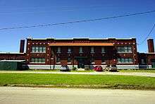 |
June 6, 1980 (#80003259) |
N. A and Jackson Sts. 34°00′43″N 95°30′53″W / 34.011944°N 95.514722°W |
Hugo | |
| 7 | Hugo Historic District | .jpg) |
November 12, 1980 (#80003260) |
U.S. Routes 70 and 271 34°00′39″N 95°30′46″W / 34.010867°N 95.512864°W |
Hugo | |
| 8 | Hugo Public Library | .jpg) |
September 8, 1988 (#88001379) |
703 E. Jackson St. 34°00′39″N 95°30′17″W / 34.0108°N 95.5048°W |
Hugo | Building replaced by the Choctaw County Public Library (pictured) in 2004. |
| 9 | Rose Hill Plantation | 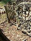 |
March 15, 2010 (#10000069) |
Address Restricted |
Hugo | |
| 10 | Speer School | September 8, 1988 (#88001380) |
Off U.S. Route 271 east on a county road 34°06′49″N 95°32′54″W / 34.113611°N 95.548333°W |
Hugo | ||
| 11 | Spencer Academy | May 21, 1975 (#75001562) |
10 miles north of Fort Towson 34°08′51″N 95°21′37″W / 34.1475°N 95.360278°W |
Fort Towson | ||
| 12 | Spencerville School Campus | September 8, 1988 (#88001381) |
South of Spencerville 34°08′31″N 95°22′13″W / 34.141944°N 95.370278°W |
Spencerville | ||
| 13 | Willie W. Wilson House | April 20, 1982 (#82003673) |
Northeastern corner of the junction of Cincinnati Ave. and Main St. 34°01′15″N 95°15′55″W / 34.02087°N 95.26541°W |
Fort Towson |
See also
| Wikimedia Commons has media related to National Register of Historic Places in Choctaw County, Oklahoma. |
References
- ↑ The latitude and longitude information provided in this table was derived originally from the National Register Information System, which has been found to be fairly accurate for about 99% of listings. For about 1% of NRIS original coordinates, experience has shown that one or both coordinates are typos or otherwise extremely far off; some corrections may have been made. A more subtle problem causes many locations to be off by up to 150 yards, depending on location in the country: most NRIS coordinates were derived from tracing out latitude and longitudes from USGS topographical quadrant maps created under the North American Datum of 1927, which differs from the current, highly accurate WGS84 GPS system used by most on-line maps. Chicago is about right, but NRIS longitudes in Washington are higher by about 4.5 seconds, and are lower by about 2.0 seconds in Maine. Latitudes differ by about 1.0 second in Florida. Some locations in this table may have been corrected to current GPS standards.
- ↑ "National Register of Historic Places: Weekly List Actions". National Park Service, United States Department of the Interior. Retrieved on October 11, 2018.
- ↑ Numbers represent an ordering by significant words. Various colorings, defined here, differentiate National Historic Landmarks and historic districts from other NRHP buildings, structures, sites or objects.
- ↑ National Park Service (2009-03-13). "National Register Information System". National Register of Historic Places. National Park Service.
- ↑ The eight-digit number below each date is the number assigned to each location in the National Register Information System database, which can be viewed by clicking the number.
| Fort Towson |
| |
|---|---|---|
| Hugo |
| |
| Spencerville |
| |
| Swink |
| |
| Topics | |
|---|---|
| Lists by states |
|
| Lists by insular areas | |
| Lists by associated states | |
| Other areas | |
| |
Municipalities and communities of Choctaw County, Oklahoma, United States | ||
|---|---|---|
| City | | |
| Towns | ||
| CDPs | ||
| Other unincorporated communities | ||
This article is issued from
Wikipedia.
The text is licensed under Creative Commons - Attribution - Sharealike.
Additional terms may apply for the media files.